
Hide
Tacolneston
hide
Hide
hide
Hide
hide
Hide
Hide
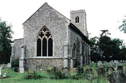
"TACOLNESTON, commonly called Tacleston, is 5 miles N.E. of New Buckenham, and 10 miles S.W. by S. of Norwich, and has in its parish 518 souls, and 1396 acres of land, belonging to many owners, the largest of whom are Sir J. B. Boileau, lord of the manor and owner of the hall, now a farm house; and J. T. G. Browne, Esq., lord of Williams and Earls manors. The Church (All Saints,) has a square tower and five bells, and was rebuilt about 1500. The rectory, valued in the King's Book at £12 has a yearly rent of £545, awarded in 1845 in lieu of tithes. The Rev. William Cobbold is incumbent, and Mrs. Warren, who has a neat residence here, is the patroness. " [William White History, Gazetteer, and Directory of Norfolk (1845) - Transcription copyright © Ann Duncan]
Hide
It may also be called Tacolston.
Hide
- 1839: Heads of households, etc.
- 1891: Surname List (this is a link to an archived copy)
See also Norfolk Parish Links: Censuses
- In 1883 the parish was in the Deanery of Depwade, in the archdeaconry of Norfolk.
It could have been in a different deanery or archdeaconry both before and after this date. - The parish church is dedicated to All Saints.
- Church of All Saints
- Picture of the church.
- Marriages
- These are not included in Boyd's Marriage Index or Phillimore's Marriage Registers.
See also Norfolk Parish Links: Church Records
For the civil registration of births, marriages and deaths between 1837 and 1930 (and for the censuses from 1851 to 1901), Tacolneston was in Depwade Registration District.
- 1845: White's History, Gazetteer, and Directory of Norfolk
- 1854: White's History, Gazetteer, and Directory of Norfolk (this is a link to an archived copy)
- 1864: White's History, Gazetteer, and Directory of Norfolk
- 1883: White's History, Gazetteer, and Directory of Norfolk
- 1883: Kelly's Directory for Cambridgeshire, Norfolk and Suffolk (this is a link to an archived copy)
See also Norfolk Parish Links: Directories
- Ask for a calculation of the distance from Tacolneston to another place.
Tacolneston is in Depwade Hundred.
- Parish outline and location.
- See Parish Map for Depwade Hundred
- Description of Depwade Hundred
- 1845: White's History, Gazetteer, and Directory of Norfolk
- Great Britain: Statute
- Tacolneston Inclosure Act, 1778.
An act for dividing, allotting and inclosing the commons and waste grounds within the parish of Tacolneston, in the county of Norfolk.
[1778]
You can see maps centred on OS grid reference TM142951 (Lat/Lon: 52.511363, 1.155538), Tacolneston which are provided by:
- OpenStreetMap
- Google Maps
- StreetMap (Current Ordnance Survey maps)
- Bing (was Multimap)
- Old Maps Online
- National Library of Scotland (Old Ordnance Survey maps)
- Vision of Britain (Click "Historical units & statistics" for administrative areas.)
- English Jurisdictions in 1851 (Unfortunately the LDS have removed the facility to enable us to specify a starting location, you will need to search yourself on their map.)
- Magic (Geographic information) (Click + on map if it doesn't show)
- GeoHack (Links to on-line maps and location specific services.)
- All places within the same township/parish shown on an Openstreetmap map.
- Nearby townships/parishes shown on an Openstreetmap map.
- Nearby places shown on an Openstreetmap map.
- After 1834 Tacolneston became part of the Depwade Union, and the workhouse was at Pulham St Mary Magdalen (Pulham Market).
- Tacolneston School Centenary Committee
- Tacolneston School centenary anniversary, 1877-1977.
[1977]