
Hide
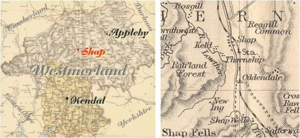
Shap
hide
Hide
hide
Hide
Hide
Hide
"SHAP, a parish in WEST ward, county of WESTMORLAND, 6 miles (N.W.) from Orton, containing, with portions of the chapelry of Mardale, of the township of Fawcet-Forest, and of the hamlet of Birbeck-Fells, 969 inhabitants. The living is a discharged vicarage, in the archdeaconry and diocese of Carlisle, rated in the king's books at £8. 15. 7., endowed with £400 private benefaction, £600 royal bounty, and £1100 parliamentary grant, and in the patronage of the Earl of Lonsdale. The church, dedicated to St. Michael, has lately received an addition of one hundred and ten free sittings, the Incorporated Society for the enlargement of churches and chapels having granted £50 towards defraying the expense. The river Lowther runs through the parish, which is bounded on the west by the lake Hawswater, and contains quarries of limestone and blue slate. "
[From Samuel Lewis A Topographical Dictionary of England (1831) - copyright Mel Lockie 2016]
Hide
There were 2 chapelries that became parishes in their own right: Mardale (1748) and Swindale (1744)
Hide
M.I.s for Shap were transcribed in Westmorland Church Notes by E. Bellasis 1888-89
| St Michael, Shap, Church of England |
Returns survive for the 'census' of 1787 and are held at the Kendal Record Office of Cumbria Archives Service. The Record Office reference is WQ/SP/C. They are transcribed in Vital Statistics published by Curwen Archives Trust 1992. ISBN 1897590008. There are trancriptions on EdenLinks for
Census returns are available from the usual sources for 1841-1911.
A transcript of the 1841 census of Shap [HO107/1162] is provided by Virginia Gretton. It includes the following names:
ABBOTT, ADDISON, AINSLEY, AIREY, ASHWORTH, ASKEW, ARNISON, ATKINSON, BAINBRIDGE, BALLANTINE, BANKS, BARNS, BECK, BENNET, BENSON, BIRBECK, BLAND, BOWSEN, BREAKS, BROWN, BRYHAM, BURN, BURTON, CARTER, CARTMELL, CASTLEY, CHAPELHOW, CLARK, COATS/COATES, COCKBURN, COOPER, COPLEY, COWARD, CUMMINGS, DENT, DENNISON, DEWHURST, DIXON, DOBSON, DOUTHWAITE, EBDALE, EDMUNDSON, ELLIDOOD, ELLISON, ESKRIGG, EUBANK (also see UBANK), FARRER, FAWCETT, FELL, FERGUSON, FIN, FLEMMING, FORSYTHE, FURNASS, GARNETT, GARSIDE, GIBSON, GOODE, GREEN, GRIFFIT, GROVES, HAIN, HALL, HARRISON, HARTLEY, HAWKSWORTH, HAYTON, HEATH, HERRING, HIGGINS, HILL, HINDSON, HOBKIRK, HODGSON, HOLME, HOW, HOWEL, HUDSON, HUNTER, HUTCHINSON, ION, JACKSON, JAQUES, JOHNSTONE, HEWATSON, KENDALL, KITCHING, KNOX, LAKE, LAMB, LAMBERT, LANCASTER, LANGHORN, LANGLEY, LATTON, LAVERICK, LIGHTON, LOWIS/LOWISE, LOWTHIAN, LUKUS, McEWIN, MACERETH, MARSHALL, MARTINDALE, MAWSON, MEDCALF, MOFFAT/MOFFET, MONKHOUSE, MOSS, MOUNSEY, NEWTON, NICHOLSON, NIVISON, NIXON, NOBLE, OBERINE, PARK, PARKER, PEARSON, POLLARD, POTTS, PRIESTMAN, RAWES, REBANKS, RELPH, RICHARDSON, RIGG, RILEY, ROBINSON, ROPER, ROW, ROWLANDSON, RUDDAM, RUDDICK, SALKELD, SANDERSON, SARGINSON, SARJANT, SCAFE/SCAIF, SCOT/SCOTT, SEWELE/SEWELL, SHANNON, SHEARMAN, SHEPHERD, SHEROW, SIMSON/SIMPSON, SMALLWOOD, SMITH, SOWERBY, STEPHENSON, STEWARD, STEWARDSON, STORROW, STRONG, SWAINSON, SWALE, SWINDLOW, TAYLOR, TEASDALE, THOMPSON, TINKLER, TODD, TOPPING, TOWERS, UBANK (also see EWBANK), WALKER, WALLIS, WANE, WARD, WELYDON, WHARTON, WHITESMITH, WHITFIELD, WILKINSON, WILLAN, WILLIAMSON, WILMAN, WILSON, WINDER, WORKMAN, WREAY, WRIGHT.
Transcript and index for 1851 has been published by the Cumbria Family History Society and also in 'North Westmorland - An Index to the 1851 Census' compiled by David Lowis and Barbara Slack.
|

|
St Michael |
|
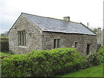
Keld Chapel |
Parish Registers and Bishop's Transcripts are held by Cumbria Archives :
originals at Kendal RO and microfilm copies at Carlisle RO.
| Baptism registers | [1559]-1948 |
| Marriage registers | 1559-1951 |
| Banns registers | 1754-1981 |
| Burial registers | [1559]-1932 |
| Bishops transcripts | 1665-1880 |
See the CASCAT online calogue for WPR84 for information on these and other parish records..
For searching on LDS familysearch.org see IGIbatch numbers (compiled by Jake Prescott)
or use the batch number search site (by Hugh Wallis).
Nicolson and Burn: The history and antiquities of the counties of Westmorland and Cumberland. 1777. Transcribed by Anne Nichols.
"Shap was invariably in ancient times written Hep or Heppe, most probably from the fruit of the bramble which still bears that name. By the common people that fruit is still pronounced choup, from whence the transition to Shap is not difficult. Nor doth it at all derogate from this account, that there are at present few shrubs of that kind there; for the face of the country is totally altered since those ancient times; for all was then forest and wood, even so late down as the foundation of the abbey. The parish of Shap is bounded on the East by the parishes of Morland and Crsoby Ravensworth; on the South, by the parishes of Crosby Ravensowrth and Orton; on the West, by the parishes of Kendal, Bampton, and Barton; and on the North, by the parishes of Bampton, Lowther, and Morland: And contains about 182 families [in 1777] ; all of the church of England except one or two. The church is dedicated to St. Michael the archangel... It is a vicarage.... The church is a pretty large ancient building; with a square tower, and three bells. Within the parish of Shap, is the manor of Rosgill or Rosegill; probably not so called from any shrub of that name growing there, as we have before supposed for Shap and of Sleagill; but rather from Rhôs or Rose, which in the British signifies a moist valley or dale. Thornthwaite was anciently a large forest. It is part in the parish of Shap, and the other part in the parish of Bampton. Mardale... is part of the forest of Thornthwaite, and lies part in the parish of Shap, and part in the parish of Bampton. The chapel of Mardale is in the parish of Shap. Swindale.. also is part of Thornthwaite forest; which extended wide in these uncultivated places. It may have received its name, either from the situation, as Swin signifies inclining or crooked; so there is a Crookdale in this same parish of Shap: Or may be so called from wild boars having frequented there; as there are in Grisedale, Boredale, Stybarrow, in the neighbouring parish of Barton; and Wildboarfell in Ravenstonedale. At this place is a small chapel, which was built by the inhabitants to answer the purpose both of school and chapel. Mosedale, Mossdale, is a wild, bleak, mossy, and mountainous dale; but profitable for fine blue slate: which, since it was found out (which is not a century ago), hath quite altered the face of the country as to building. It is a beautiful, dry, clean, light covering; and, in Westmorland, by reason of its vicinity, cheaper than thatch, because durable. Much of it, by land-carriage, is conveyed over Stanemore into the counties of Durham and York. South-west about a mile and an half from Shap is the hamlet of Sleddale, Sleadale, distinguished from another Sleddale in the barony of Kendale by the name of Wet Sleddale; for if any rain is stirring, the air scoops it surprisingly into the hollow of that dale. Next we come to the manor of Hardendale and Wasdale (Waste dale)...[which] belonged to Byland abbey in Yorkshire. "
The details for the parish from the Parson & White's Directory for 1829 are transcribed on Edenlinks site.
- Ask for a calculation of the distance from Shap to another place.
The Later Records relating to North Westmorland by John F. Curwen (1932) are available on British History Online
Cumbria County History Trust has published a "Jubilee Digest" for the township of Shap
Magna Britannica et Hibernia.Volume 6: Westmorland 1731 by Thomas Cox
Transcription by Sarah Reveley, Joan Fisher and Lisl Schoenwald. (Rootsweb Westmorland Listmembers) (c) 2003
"Hep, Hepe, or as now 'tis called Shap, a small Village, once famous for a small Monastery, of which we shall hereafter in its Place particularly speak, but now of no Note, save for certain great Stones in the Form of Pyramids, (some of them nine Foot high, and fourteen thick) almost in a direct Line, and at equal Distances for a Mile together. They seem intended to be the Memorials of some Action or other, but Distance of Time hath made it impossible for us to find out the Occasion, having no History of this County.
Robert de Vipont, a Parliamentary Baron, and a Person much in Favour with King John, was Lord of this Town as Part of his Barony of Appleby, and it seems upon some Occasion laid up his Arms (for he was a very warlike Person) in the Abbey of Hep. He died indebted to King Hen. III. Reg 12 in the Sum of 199 pounds, 11 shillings 6 pence five great Horses, and five Tan of Wine; whereupon the King after his Death, sent his Precept to the Abbot of Hep, to deliver! up all the Arms belonging to the said Robert, which were in his Custody, to this Bailiff to be kept in his Castles. Roger Lord Clifford 4th died possessed of this Manor 13 Rich. II. But how it came into his Family from the Viponts we have not discovered as yet."
You can see maps centred on OS grid reference NY515114 (Lat/Lon: 54.495368, -2.750809), Shap which are provided by:
- OpenStreetMap
- Google Maps
- StreetMap (Current Ordnance Survey maps)
- Bing (was Multimap)
- Old Maps Online
- National Library of Scotland (Old Ordnance Survey maps)
- Vision of Britain (Click "Historical units & statistics" for administrative areas.)
- English Jurisdictions in 1851 (Unfortunately the LDS have removed the facility to enable us to specify a starting location, you will need to search yourself on their map.)
- Magic (Geographic information) (Click + on map if it doesn't show)
- GeoHack (Links to on-line maps and location specific services.)
- All places within the same township/parish shown on an Openstreetmap map.
- Nearby townships/parishes shown on an Openstreetmap map.
- Nearby places shown on an Openstreetmap map.
Details for the West Ward workhouse (Hackthorp) are given.
The West Ward Union workhouse was situated in Shap. Details are on the website of Peter Higginbotham .
Shap is in the diocese of Carlisle and wills will be in Carlisle Record Office.
Hearth Tax records for 1674 Shap transcribed on Edenlinks
Hearth Tax records for 1674 Rayside (Shap) transcribed on Edenlinks.
Hearth Tax records for 1674 Sleddal in the Bottom (Shap) transcribed on Edenlinks.
Hearth Tax records for 1674 Hardendale (Shap) transcribed on Edenlinks.