
Hide
Bridlington
hide
Hide
hide
Hide
hide
Hide
Hide
The Ancient Parish of BRIDLINGTON
[Transcribed information mainly from the early 1820s]
"BRIDLINGTON, or Burlington, or Bridlington Old Town, a parish in the wapentake of Dickering; 8 miles from Hunmanby; 12 from Driffield, 18 from Scarborough, 40 from York, and 201 from London, by way of Lincoln. This town is situated on the Eastern coast, about a mile from the shore, in the recess of the commodious and beautiful bay to which it affords its name. It consists chiefly of one long irregularly framed street, extending along the Southern declivity of a small elevation, and its situation is both pleasant and salubrious." (There is further information for Bridlington).Information on the following places in this Parish is contained on a supplementary page.
|
|
[Description(s) edited mainly from various 19th century sources by Colin Hinson. ©2010]
Hide
- Bridlington Central Library is located in King Street, Bridlington, East Riding of Yorkshire, YO15 2DF. It has an extensive local and family history section.
- Photographs of over 550 gravestones in Bridlington Priory Church churchyard.
- Photographs of over 90 plaques etc. inside Bridlington Priory Church.
- Photographs of over 10,000 gravestones in Bridlington Cemetery with linked surname index.
- Photographs of the 31 gravestones in the 2nd Baptist Church Graveyard with linked surname index.
- Photographs of over 50 gravestones and plaques at Grindale with linked surname index.
- Photographs of over 300 gravestones and plaques at Sewerby Church with linked surname index.
- The List of Charities in Priory Church, Bridlington.
- The Church information and photographs are now on a separate page.
- Lisa Blosfelds has transcribed the Reighton and Speeton parish magazines for 1893 to 1913.
- A transcript of Bridlington Baptist Church History up to 1912
- Transcript of the entry for Bridlington in the "Collections relative to Churches and Chapels".
- Transcript of the entry for Grindale in the "Collections relative to Churches and Chapels".
- Transcript of the entry for Speeton in the "Collections relative to Churches and Chapels".
- A transcript of Bridlington Congregational Church History
- The list of Head Choristers 1956-1975, in Priory Church, Bridlington
- The Church Records information is now on a separate page.
- Bridlington.net: here you will find information relating to all aspects of Bridlington, whether your interest is that of a potential visitor to the area or a Bridlington resident. (use the "Menu category" select at the top of the page).
- Sewerby
- Transcript of the entry of "professions and trades" in the Baines's Directory of 1823, of the East Riding.
- Transcript of the entry of "professions and trades" in the Pigot's 1829 Directory, Yorkshire section.
- Transcript of the entry of "professions and trades" in the Pigot's 1834 Directory, Yorkshire section.
- Transcript of the entry of "professions and trades" in the White's Directory of 1840, Yorkshire section.
- Transcript of the entry of "professions and trades" in the Bulmers Directory of 1892. of the East Riding.
- There is further information about this parish from the Pigot's 1829 Directory, Yorkshire section.
- There is further information about this parish from the Pigot's 1834 Directory, Yorkshire section.
- There is further information about this parish from the National Gazetteer 1868, Yorkshire extracts.
- There is further information about this parish from the Lewis's Topographical Dictionary of England 1835, Yorkshire extracts.
- There is further information about this parish from the Stephen Whatley's Gazetteer 1750, Yorkshire extracts.
- There is further information about this parish from the Bulmer's 1892 History and Directory of the East Riding.
- Ask for a calculation of the distance from Bridlington to another place.
- The List of Creyke Family dates in Priory Church, Bridlington.
- Circa 1850, the townships of Sewerby-cum-Marton and Grindale were formed into a separate parish. See Sewerby Parish.
- Between 1823 and 1892, the chapelry of Speeton (in this parish) was formed into a parish in its own right. See Speeton Parish.
- Lisa Blosfelds has transcribed the Reighton and Speeton parish magazines for 1893 to 1913.
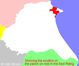
- For a detailed map of this parish see this parish boundaries map.
- For a more detailed map of the parishes in the riding please see the Yorkshire parish maps page.
- For a more detailed map of the county please see the Yorkshire map page.
- Here is a map showing the wapentakes for the county.
You can see maps centred on OS grid reference TA178680 (Lat/Lon: 54.094427, -0.200262), Bridlington which are provided by:
- OpenStreetMap
- Google Maps
- StreetMap (Current Ordnance Survey maps)
- Bing (was Multimap)
- Old Maps Online
- National Library of Scotland (Old Ordnance Survey maps)
- Vision of Britain (Click "Historical units & statistics" for administrative areas.)
- English Jurisdictions in 1851 (Unfortunately the LDS have removed the facility to enable us to specify a starting location, you will need to search yourself on their map.)
- Magic (Geographic information) (Click + on map if it doesn't show)
- GeoHack (Links to on-line maps and location specific services.)
- All places within the same township/parish shown on an Openstreetmap map.
- Nearby townships/parishes shown on an Openstreetmap map.
- Nearby places shown on an Openstreetmap map.
- The World War II memorial screen in Priory Church, Bridlington.
- The World War II memorial screen for the 23rd Hussars in Priory Church, Bridlington.
- The World Wars I and II Roll of Honour on the Memorial near Christ Church, Quay.
- The 1914-1919 Memorial Plaque for St. John's Wesleyan Church, Bridlington.
- The 1914-18 Memorial plaque in Priory (St. Mary's) Church, Bridlington Old Town.
- The World War I Roll of Honour in Speeton Church.
- The World War II Roll of Honour in Speeton Church.
- The 1914-18 War Memorial Plaque on the wall in Christ Church.
- The 1914-18 War Memorial Plaque on the wall in Trinity Church.
- The 1939-45 War Memorial Plaque on the wall in Christ Church.
- The 1914-1918 War Memorial in Sewerby Churchyard.
- The following places are within the boundaries of this (ancient) parish, but I have no further information on them other than the Ordnance Survey Landranger Grid reference shown:
- (TA166706) East Huntow
- (TA189704) Field House
- (TA188710) High Barn
- (TA204708) Lynhams
- (TA191695) Marton Lodge
- (TA154720) North Dale
- (TA174704) North Mount
- (TA172699) The Grange
- (TA164701) West Huntow
- The Rules for farming at Reighton and Speeton for 1727 transcribed by Lisa Blosfelds and presented as a pdf document.
- A list of ale sellers and Reighton and Speeton 1754-98, compiled by Lisa Blosfelds.
- Pam Smith has supplied an article on "The Climmers" or Egg Gatherers of the cliffs of Filey, Speeton, Bempton and Flamborough.
- A transcription of the Reighton and Speeton Board School Records, 1877-1903 in Adobe pdf format.
- This parish is covered by the following Society:
- A list of Hearth Tax payers for Reighton and Speeton, 1672 A list of Hearth Tax payers for Reighton and Speeton, 1672
- The 1834 Electoral Roll for this parish