
Hide
Kirby Underdale
hide
Hide
hide
Hide
Hide
The Ancient Parish of KIRBY UNDERDALE
[Transcribed information mainly from the early 1820s]
"KIRBY UNDERDALE, a parish in the wapentake of Buckrose, 7 miles N. of Pocklington. The church is dedicated to All Saints (see Churches for photograph) and the living is in the patronage of the King. Pop. 335.""BAFFAM, a farm house in the township and parish of Kirby-Underdale; 1 mile WNW. of Kirby Underdale, 8 miles from Pocklington."
"DEEPDALE, in the parish of Kirby-Underdale, wapentake of Buckrose; 2¾ miles SSE. of Kirby Underdale, 9 miles from Malton, Sledmere, and Pocklington."
"GARROWBY, 3 houses in the parish of Kirby Underdale, and wapentake of Buckrose; 1¼ miles SSW. of Kirby Underdale, 6 miles N. of Pocklington. Pop. included with Kirby Underdale."
"HANGING GRIMSTONE, in the parish of Kirby Underdale, and wapentake of Buckrose; 1¾ miles N. of Kirby Underdale, 8 miles N. of Pocklington."
"MILL HOUSES, in the parish of Kirby Underdale, and wapentake of Buckrose; 9 miles from Pocklington."
"PAINSTHORPE, a hamlet in the parish of Kirby Underdale, and wapentake of Buckrose; ½ mile ESE. of Kirby Underdale, 7 miles N. of Pocklington."
"UNCLEBY, 3 or 4 farm houses in the parish of Kirby Underdale, and wapentake of Buckrose; ½ mile NE. of Kirby Underdale, 7 miles N. of Pocklington."
"WOODLEY, a farm house in the parish of Kirby Underdale, and wapentake of Buckrose; ¾ mile NNE. of Kirby Underdale, 9 miles from Malton."
[Description(s) edited mainly from various 19th century sources by Colin Hinson. ©2010]
Hide
- Photographs of over 130 gravestones in Kirby Underdale Churchyard with a surname index.
- Here is a photograph of All Saints' Church, Kirby Underdale.
- Internal view looking down the aisle
- The East Window
- The font
- Transcript of the entry for Kirby Underdale in the "Collections relative to Churches and Chapels".
- The dates of various parts of the Churchon a plaque in All Saints Church, Kirby Underdale.
- The whereabouts and dates of the Registers etc. for the Parish of Kirby Underdale.
- Transcript of the entry of "professions and trades" in the Baines's Directory of 1823, of the East Riding.
- Transcript of the entry of "professions and trades" in the The Post Office Directory of the, East and North Ridings, 1857
- Transcript of the entry of "professions and trades" in the Bulmers Directory of 1892. of the East Riding.
- There is further information about this parish from the National Gazetteer 1868, Yorkshire extracts.
- There is further information about this parish from the Lewis's Topographical Dictionary of England 1835, Yorkshire extracts.
- There is further information about this parish from the Bulmer's 1892 History and Directory of the East Riding.
- Ask for a calculation of the distance from Kirby Underdale to another place.
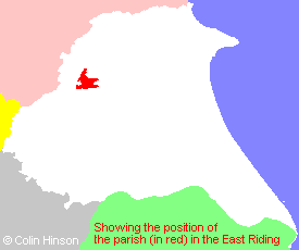
- For a detailed map of this parish see this parish boundaries map.
- For a more detailed map of the parishes in the riding please see the Yorkshire parish maps page.
- For a more detailed map of the county please see the Yorkshire map page.
- Here is a map showing the wapentakes for the county.
You can see maps centred on OS grid reference SE806586 (Lat/Lon: 54.017124, -0.771389), Kirby Underdale which are provided by:
- OpenStreetMap
- Google Maps
- StreetMap (Current Ordnance Survey maps)
- Bing (was Multimap)
- Old Maps Online
- National Library of Scotland (Old Ordnance Survey maps)
- Vision of Britain (Click "Historical units & statistics" for administrative areas.)
- English Jurisdictions in 1851 (Unfortunately the LDS have removed the facility to enable us to specify a starting location, you will need to search yourself on their map.)
- Magic (Geographic information) (Click + on map if it doesn't show)
- GeoHack (Links to on-line maps and location specific services.)
- All places within the same township/parish shown on an Openstreetmap map.
- Nearby townships/parishes shown on an Openstreetmap map.
- Nearby places shown on an Openstreetmap map.
- This parish is covered (or partly covered) by the following Societies:
- The 1834 Electoral Roll for this parish