
Hide
Dumfriesshire Parish Map
hide
Hide
The map below shows the locations of the various parishes in Dumfriesshire, and the names of the neighbouring counties. The numbered parishes are named in the table beneath the map.
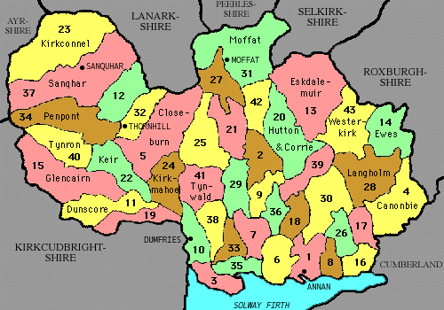
| Annan (1) Applegarth (2) Caerlaverock (3) Canonbie (4) Closeburn (5) Cummertrees (6) Dalton (7) Dornock (8) Dryfesdale (9) Dumfries (10) Dunscore (11) Durisdeer (12) Eskdalemuir (13) Ewes (14) | Glencairn (15) Gretna (16) Halfmorton (17) Hoddam (18) Holywood (19) Hutton (20) Johnstone (21) Keir (22) Kirkconnel (23) Kirkmahoe (24) Kirkmichael (25) Kirkpatrick Fleming (26) Kirkpatrick Juxta (27) Langholm (28) Lochmaben (29) | Middlebie (30) Moffat (31) Morton (32) Mouswald (33) Penpont (34) Ruthwell (35) St Mungo (36) Sanquhar (37) Torthorwald (38) Tundergarth (39) Tynron (40) Tinwald (41) Wamphray (42) Westerkirk (43) |