
Hide
Merthyr Mawr
hide
Hide
hide
Hide
hide
Hide
Hide
"MERTHYR MAWR, in the Cwmwd of Maenor Glynn Ogwr, Cantref of Cron Nedd (now called the Hundred of Ogmore), Co. of GLAMORGAN, South Wales: a Perpetual Curacy, not in charge, of the certified value of £13..6..8: Patron, The Archdeacon of Llandaff: Church dedicated to St. Teilo. The Resident Population of this Parish, in 1801, was 138. The Money raised by the Parish Rates, in 1803, was £80..11..0, at 3s. 7d. in the pound. It is 7 m. S.W. from Cowbridge. This Parish contains from eight hundred to one thousand acres of Land: one hundred of which are Sand banks, that cannot be cultivated. Here are the vestiges of an old Chapel, commonly called Cappel St. Roque. According to the Diocesan Report, in 1809, the yearly value of this Benefice, arising from Stipend, and Augumentation, was £42..16..4. It is a well-wooded, pleasant village, on the Western bank of the river Ogwr: and on the Eastern side are the remains of a strong Castle, which was erected by William de London, who possessed the Lordship of Aber Ogwr." From: A Topographical Dictionary of The Dominion of Wales by Nicholas Carlisle, London, 1811.
Hide
Here is a substantial reading list of books which relate to Glamorgan, either county or parish.
Glamorgan Chapels Database - no conconformist chapels found in this parish
See Welsh Chapels and Churches for a photograph
Various items - on the People's Collection Wales site
- Merthyr Mawr Church
- Colour transparency showing a view of St Roque's Chapel, Merthyr Mawr produced by RCAHMW, c.1980
For full and up-to-date details of their holdings see the sites of Glamorgan Record Office and/or West Glamorgan Archives
See Bap/Mar/Bur data on FreeReg
The church is dedicated to St. Teilo, and is in the Benefice of Laleston with Tythegston and Merthyr Mawr. Details of the present incumbent of this benefice can be found at the Church in Wales website. The church can be located at grid reference SS883775.
A transcription of the registers is available from the Glamorgan Family History Society for the years: Baptisms, 1696-1899, Marriages, 1737-1836, Burials, 1696-1899.
| Anglican Parish Registers Held at the Glamorgan Record Office, Cardiff | ||||
| Baptisms | Marriages | Burials | Banns | Bishops Transcripts |
| 1749-1981 | 1756-1970 | 1749-1988 | - | 1696, 1721, 1723-1837 |
Details of extant records on Archives Network Wales for the following;
- Merthyr Mawr Ecclesiastical Parish records " .......... including registers of baptisms, 1749-1981; burials, 1749-1988; marriages, 1756-1970; banns, 1823-1988; services, 1900-1954; records relating to: property, 1856-1920; churchwardens, 1768-1931; miscellaneous and civil matters, 1767-1934; parochial church council, 1926"
The following Religious Institutions are covered in the Mormon International Genealogical Index (IGI) :-
- Merthyr Mawr, St. Teilo - Christenings (BT's), 1813-1871
Merhyr Mawr - on Wikipedia
Various items - on the People's Collection Wales site
- Abandoned C19th Rifle Range on Merthyr Mawr, 1931
- The 'Old Portway' abandoned road across Merthyr Mawr sand dunes, 1931
- Various landscapes
Transcript of name listing for Bridgend and district, from Slaters Directory for 1880.
The transcription of the section for Merthyr Mawr from The National Gazetteer (1868) provided by Colin Hinson.
Description of parish from A Topographical Dictionary of Wales (1833) by Samuel Lewis.
- Ask for a calculation of the distance from Merthyr Mawr to another place.
Description and image of Candleston Castle at www.castlewales.com by Jeff Thomas
- Merthyr Mawr tithes
1825-42: tithe surveys compiled prior to award 1829-35, accounts and papers rel to commutation 1825-42
[Glamorgan Archive Service, Cardiff - Reference: D/DN] - Nicholl family of Merthyr Mawr
c1420-1966: deeds c1420-1957, manorial and estate papers 1619-1966, probate etc 1830-1936, legal papers 19th cent, personal papers 1787-19th century
[Glamorgan Archive Service, Cardiff - Reference: D/DN]
Details of extant records on Archives Network Wales for the following;
- Merthyr Mawr estate collection 1662, 1730-1966 & [c. 1420]-1966 "The Nicholl family of Merthyr MawrGlamorgan, was a junior branch of the Nicholl family of Ham, Glamorgan. John Nicholl (d 1773) of Llanmaes, Glamorgan, third son of the Rev. Iltyd Nicholl of Ham, was the father of Sir John Nicholl (1759-1838), Dean of the Court of Arches, Judge of the Prerogative Court of Canterbury, Judge of the High Court of Admiralty, 1833, and Vicar-General of the Archbishop of Canterbury, 1834, who was mainly responsible for establishing the Merthyr Mawr estate............................."
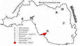
This diagram shows the position of this parish within the county of Glamorgan - click on this to see a full size diagram of the county
|
Plan of the parish of Merthyr Mawr in the County of Glamorgan - on the People's Collection Wales site
Parish map (Kain/Oliver)
You can see maps centred on OS grid reference SS868775 (Lat/Lon: 51.484695, -3.631111), Merthyr Mawr which are provided by:
- OpenStreetMap
- Google Maps
- StreetMap (Current Ordnance Survey maps)
- OpenStreetMap Cymru (Welsh counties only)
- Bing (was Multimap)
- Old Maps Online
- National Library of Scotland (Old Ordnance Survey maps)
- Vision of Britain (Click "Historical units & statistics" for administrative areas.)
- Magic (Geographic information) (Click + on map if it doesn't show)
- GeoHack (Links to on-line maps and location specific services.)
- All places within the same township/parish shown on an Openstreetmap map.
- Nearby townships/parishes shown on an Openstreetmap map.
- Nearby places shown on an Openstreetmap map.
Places, villages, farms etc within Merthyr Mawras shown on the online parish map from the CD of Historic Parishes of England and Wales: an Electronic Map of Boundaries before 1850 with a Gazetteer and Metadata [computer file]. (Kain, R.J.P., Oliver, R.R.). (Extracted by Gareth Hicks)
- Merthyr Mawr (103); Bevos Fm.; Black Rocks; Buildings; Candleston; Candleston Castle; Chapel Hill; Cog-y-Brain; Craig y Parcau; Cwm Quintin; Cwm y Gaer; Golf Links; Merthyr Mawr; Merthyr Mawr Ho.; Merthyr Mawr Warren; Ogmore (Ogwr) River; R. Range; Traeth yr Afon; Tyle; Warren; Whitney; Wick Fach; Y Gaer; Ysgubor Quintin.
There are many references to this area in the 15 million Welsh and English language articles from Welsh newspapers transcribed by the NLW and viewable on Welsh Newspapers Online
Below are English language articles that have been re-transcribed and extracted randomly to illustrate what is available, there are many that are not extracted here that include names of local people
- From The Brecon County Times Neath Gazette and General…21st August 1869
MERTHYR MAWR. ARCHERY.-The annual archery competition of the district took place at Merthyr Mawr on Monday last, when a large number of ladies and gentlemen entered the lists for the prizes offered on the occasion. The competition was carried out with considerable spirit, and the proceedings were enlivened by the performance of an excellent selection of music by a band specially engaged tor the day. The prizes were supplied by Mr. Barry, of Neath, whose unique display was much admired, practical approval being shown by the numerous private purchases made at the close of the sport.
- From The Glamorgan Gazette 30th October 1914
MERTHYR MAWR HOUSE. ITS FINE SITUATION. ITS HISTORY AND ASSOCIATIONS. (By Mr. T. M. Price, Late of Boverton). Within a few miles radius of the thriving market town of Bridgend there are many notable mansions and places of interest to the antiquary, historian, and tourist. Among these may be noted Merthyrmawr, the home ot Mr. John Iltyd Dillwyn Nicholl. D.L., J.P. The mansion occupies a finely diversified situation a couple of miles south-west of Bridgend, in the centre of one of the most engrossing sites of Morganwg. Perhaps it would be somewhat difficult to find in the whole county of Glamorgan a district which presents such Is number of varied attractions as that of which Merthyrmawr is the centre .....(part extract).......
- From the Evening Express (Third Edition) 25th April 1904
SAND HILLS OF MERTHYR MAWR. An interesting lecture, was delivered in Llantrisant National Schoolroom on "The Sand Hills of Merthyr Mawr" by Mr. A. E. Harris, of Cardiff, and illustrated by an excellent series of lantern views. In the unavoidable absence of his Honour Judge Williams, of Miskin, the chair was taken by Mr. Meyler Thomas, of Ynysyplwm. There was a large audience of ladies and gentlemen
- From The Glamorgan Gazette 11th August 1916
FETE AT MERTHYR MAWR HOUSE IN AID OF BRIDGEND RED CROSS HOSPITAL. The weather, and circumstances all propitious, combined to favour and secure the success of the grand fete held on Wednesday at Merthyrmawr House, the residence of Col. J. I. D. Nicholl and Mrs. Nicholl,-who generously threw the grounds open, and were thoughtfully assiduous for the pleasure and comfort of the visitors, who poured in in a continuous stream in motor, brake, and every form of equipage from Bridgend and the Valleys. The worthy object was to assist the Bridgend Red Cross Hospital—an institution that appeals with special significance to the generous impulses of the community, and the company was so large, and the opportunities of rendering help so manifold, that the financial result must have been considerable, and it may be hoped, up to the most sanguine expectations of the promoters. .....(part extract).......
The Population of Merthyr Mawr was as follows, and a more detailed breakdown is available.
| 1841 - 147 | 1851 - 154 | 1861 - 174 | 1871 - 144 | 1881 - 120 | 1891 - 121 |
Details of extant records on Archives Network Wales for the following;
- Merthyr Mawr Civil Parish records " ....... comprising tithe plan and apportionment, 1843-1844; parish meeting minutes, 1894-1968"