
Hide
Pennard
hide
Hide
hide
Hide
hide
Hide
Hide
"A parish in Gower on the east side of Oxwich bay. Overlooking a sandy creek are the ruins of a castle, and the face of the cliffs are perforated with bone caverns. The neighbouring village of Parkmill is much visited for its picturesqueness." [Glamorganshire, 1911]
"PARK Mill is a village in the parishes of Pennard and Illston, 4 miles from Killay station on the London, Midland and Scottish railway and 8 from Swansea. There is a Congregational chapel here." [From Kelly's South Wales Directory 1923 (ArchiveCDBooks) - transcribed by Gareth Hicks]
Hide
Here is a substantial reading list of books which relate to Glamorgan, either county or parish.
The Glamorgan Family History Society have produced a set of microfiche containing Monumental Inscriptions for the following burial grounds :-
- Parish Church of St. Mary
Chapels Database - a list of all known non-conformist chapels or other non-Anglican religions in the parish
Pennard - St Mary's Church - on the People's Collection Wales site
For full and up-to-date details of their holdings see the sites of Glamorgan Record Office and/or West Glamorgan Archives
See Bap/Mar/Bur data on FreeReg
The church is dedicated to St. Mary, is in the Benefice of Ilston with Pennard with Nicholaston, and diocese of Swansea and Brecon. Details of the present incumbent of this benefice can be found at the Church in Wales website. The church can be located at grid reference SS566887.
| Anglican Parish Registers Held at the National Library of Wales, Aberystwyth | ||||
| Baptisms | Marriages | Burials | Banns | Bishops Transcripts |
| 1743-1965 | 1743-1971 | 1743-1944 | - | 1677-1679, 1681-1684, 1686, 1690, 1693, 1696-1697, 1699-1702, 1704, 1707, 1710, 1713, 1716, 1718, 1725, 1727, 1729-1740, 1742-1771, 1773-1776, 1778-1780, 1782-1795, 1797-1800, 1802-1803, 1805-1806, 1808-1882, 1885, 1887-1891 |
The following Religious Institutions are covered in the Mormon International Genealogical Index (IGI) :-
- Pennard, St. Mary - Christenings (BT's), 1813-1875
-
Park Mill - For full and up-to-date details of their holdings see the sites of Glamorgan Record Office (link is external) and/or West Glamorgan Archives (link is external)
Non Conformist Registers deposited at the National Library of Wales, Aberystwyth Chapel Baptisms Marriages Burials OS Map Ref Park Mill, Mount Pisgah, Congregational - - 1825 SS 55308946
Various landscapes - on the People's Collection Wales site
Transcript of complete name listing for the Gower parishes, from Slaters Directory for 1880. OYSTERMOUTH with the parishes of Bishopston, Cheriton, Ilston, Knelston, Llandewi, Llangennith, Llanmadoc, Llanrhidian (Higher & Lower), Nicholaston, Oxwich, Penmaen, Pennard, Penrice, Porteynon, Reynoldston, Rhoscilly, and the villages of Horton, Kilibion, Mumbles, Park Mill, Penclawdd, Walterstone and West Cross.
The transcription of the section for Pennard from The National Gazetteer (1868) provided by Colin Hinson.
Descriptions of the parish from
A Topographical Dictionary of Wales (1833) by Samuel Lewis and
A Topographical Dictionary of The Dominion of Wales by Nicholas Carlisle, London, 1811.
- Ask for a calculation of the distance from Pennard to another place.
Some of the hamlets, towns and villages within this parish
|
|
Description and image of Pennard Castle at www.castlewales.com by Jeff Thomas
Various items - on the People's Collection Wales site
- Extract from the Manorial Rolls of Oystermouth and Pennard, 1662-1676
- Pennard Castle from interior of court (1855-1860). Print created in 1934 from Francis Lockey's calotype negative.
- A view of the ruins of Pennard castle with sightseers walking towards it. In the background one can see small boats sailing.
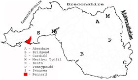
This diagram shows the position of this parish within the county of Glamorgan - click on this to see a full size diagram of the county
|
Map of the parish of Pennard, Glamorganshire - on the People's Collection Wales site
Parish map (Kain/Oliver)
You can see maps centred on OS grid reference SS568893 (Lat/Lon: 51.584182, -4.068889), Pennard which are provided by:
- OpenStreetMap
- Google Maps
- StreetMap (Current Ordnance Survey maps)
- OpenStreetMap Cymru (Welsh counties only)
- Bing (was Multimap)
- Old Maps Online
- National Library of Scotland (Old Ordnance Survey maps)
- Vision of Britain (Click "Historical units & statistics" for administrative areas.)
- Magic (Geographic information) (Click + on map if it doesn't show)
- GeoHack (Links to on-line maps and location specific services.)
- All places within the same township/parish shown on an Openstreetmap map.
- Nearby townships/parishes shown on an Openstreetmap map.
- Nearby places shown on an Openstreetmap map.
Places, villages, farms etc within Pennard parish as shown on the online parish map from the CD of Historic Parishes of England and Wales: an Electronic Map of Boundaries before 1850 with a Gazetteer and Metadata [computer file]. (Kain, R.J.P., Oliver, R.R.). (Extracted by Mary Greatorex)
- Pennard (43): Bacon Hole, Bishopton Valley, Camp, Church, Deep Slade, Fox Hole, Golf Links, Graves End, Great Kittle, Hael, High Penard, High Tor, Highway, Hunts, Inn, Kilvrough, Kilvrough Farm, Kittlehill, Kittle Inn, Langrove, Mitchin Hole, Moorlakes Wood, Murton, Penard, Penard Burch, Penard Burrows, Penard Castle, Penard Pill, Pwll-du Head, Sandylane, Shire Combe, Southgate, The Pit, Three Cliff Bay, Well, Widegate.
- Pennard (43) detached : Chapel (?), Murton
There are many references to this area in the 15 million Welsh and English language articles from Welsh newspapers transcribed by the NLW and viewable on Welsh Newspapers Online
Below are English language articles that have been re-transcribed and extracted randomly to illustrate what is available, there are many that are not extracted here that include names of local people
- From The South Wales Daily Post 3rd May 1910
PENNARD COURT LEET. MEDIAEVAL CUSTOM CONTINUED AT PARKMILL The annual court leat of the freeholders and Copyholders of Lady Lyons Manor of Pennard, and the "Fees of KIttle and Lunnon," was held at the Gower Inn, Parkmill, on Monday There were about thirty copy- holders and freeholders. ......(part extract)......
- From The Cambrian 9th August 1907
POINTS ABOUT PENNARD. OF INTEREST TO GOWER CAMPERS- AND OTHERS. PENNARD'S IMPORTANCE IN THE DAYS OF YORE. "Lewis's Topographical Gazetteer al Wales," in reference to Pennard, Gower, refers to works which were being carried out by Major Penrice, of Kilvrough, which shows it must have been issued a few years prior to 1846, for it was in that year that the Major died. "Pennarth, or Pennard (Pen-arth), a parish in the hundred of Swansea, 7½ miles (W.S.W.) from Swansea, containing 357 inhabitants." [By the way, there is a pencilled note in one of the old registers to this effect—"Census 1841. Population of Pennard 372. Inhabited houses 71.] The article continues :— "The name of this parish, signifying the 'bear's head', is supposed to be derived from the peculiar form which this part oi the coast assumes in its projection into the Bristol Channel. Pennard is thought to have been originally of more importance and of much greater extent than at present; the remains of an ancient castle, which appears to have been a structure of some magnificence, and the ruins of the ancient church, and foundations of numerous buildings, now covered with sands, afford striking evidence in support of this opinion. ......(part extract of a lengthy article)......
The Population of Pennard was as follows, and a more detailed breakdown is available.
| 1841 - 372 | 1851 - 348 | 1861 - 321 | 1871 - 285 | 1881 - 269 | 1891 - 240 |
Details of extant records on Archives Network Wales for the following;
- Pennard Parish and Community Council Records " ........ including minute books, 1953-2000; councillors' declarations of acceptance, 1948-1974; receipt and payment books, 1946-1984; photocopy [late 20th century] of tithe plan and apportionment, 1846."