
Hide
St Andrews Major
hide
Hide
hide
Hide
hide
Hide
Hide
"ANDREW'S, ST., in the Cwmwd of Is Caeth, Cantref of Brenhinol (now called the Hundred of Dinas Powys), County of GLAMORGAN, South Wales: a Rectory, valued in the King's Books at £14..13..1 1/2: Patron, The King. The Resident Population of this Parish, in 1801, was 420. The Money raised by the Parish Rates, in 1803, was £273..19..8, at 6s. 9d. in the pound. It is 5 m. S. W. from Caerdiff. This Parish is inclosed. The name of the Village is Dinas Powys. It is situate near the Bristol Channel. The present worthy Rector, BENJAMIN HALL, D. D., most obligingly adds, "Here are the remains of an ancient Castle, called Dinas Powys Castle, formerly the property of Lord Brook, now of the Widow of the late William Hurst, Esq."
From: A Topographical Dictionary of The Dominion of Wales by Nicholas Carlisle, London, 1811
Hide
Here is a substantial reading list of books which relate to Glamorgan, either county or parish.
The Glamorgan Family History Society have produced a set of microfiche containing Monumental Inscriptions for the following burial grounds :-
- Parish Church of St. Andrew
Chapels Database - a list of all known non-conformist chapels or other non-Anglican religions in the parish
See Welsh Chapels and Churches for photographs of various churches/chapels in this parish
For full and up-to-date details of their holdings see the sites of Glamorgan Record Office and/or West Glamorgan Archives
See Bap/Mar/Bur data on FreeReg
The church is dedicated to St. Andrew, and is in the Benefice of St. Andrews Major and Michaelston-le-Pit. Details of the present incumbent of this benefice can be found at the Church in Wales website. The church can be located at grid reference ST139714.
A transcription of the registers is available from the Glamorgan Family History Society for the years: Baptisms, 1696-1905, Marriages, 1696-1837, Burials, 1696-1901.
| Anglican Parish Registers Held at the Glamorgan Record Office, Cardiff | ||||
| Baptisms | Marriages | Burials | Banns | Bishops Transcripts |
| 1744-1757, 1771-1931 | 1749-1940 | 1745-1756, 1772-1940 | 1824-1920 | 1696, 1724-1837 |
Details of extant records on Archives Network Wales for the following;
- St Andrews Major Ecclesiastical Parish records "........ including registers of baptisms, 1744-1931; marriages, 1749-1940; burials, 1744-1940; banns, 1824-1920; services, 1917-1930; miscellaneous records, 1980"
Modern Parishes & Chapels of Ease :-
The following Religious Institutions are covered in the Mormon International Genealogical Index (IGI) :-
- St. Andrews Major, St. Andrew - Christenings (BT's), 1791-1873
St Andrews Major - on Wikipedia
The transcription of the section for St Andrews Major from The National Gazetteer (1868) provided by Colin Hinson.
Description of parish from A Topographical Dictionary of Wales (1833) by Samuel Lewis
- Ask for a calculation of the distance from St Andrews Major to another place.
Some of the hamlets, towns and villages within this parish
|
|
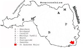
This diagram shows the position of this parish within the county of Glamorgan - click on this to see a full size diagram of the county
|
Parish map (Kain/Oliver)
You can see maps centred on OS grid reference ST141708 (Lat/Lon: 51.429554, -3.237276), St Andrews Major which are provided by:
- OpenStreetMap
- Google Maps
- StreetMap (Current Ordnance Survey maps)
- OpenStreetMap Cymru (Welsh counties only)
- Bing (was Multimap)
- Old Maps Online
- National Library of Scotland (Old Ordnance Survey maps)
- Vision of Britain (Click "Historical units & statistics" for administrative areas.)
- Magic (Geographic information) (Click + on map if it doesn't show)
- GeoHack (Links to on-line maps and location specific services.)
- All places within the same township/parish shown on an Openstreetmap map.
- Nearby townships/parishes shown on an Openstreetmap map.
- Nearby places shown on an Openstreetmap map.
Places, villages, farms etc within St Andrews Major parishas shown on the online parish map from the CD of Historic Parishes of England and Wales: an Electronic Map of Boundaries before 1850 with a Gazetteer and Metadata [computer file]. (Kain, R.J.P., Oliver, R.R.). (Extracted by Gareth Hicks)
- St Andrews Major (178); Argae; Beauville; Biglis; Cadoxton Riv.; Castle (2); Cog Moors; Cross; Crow Hill; Dinas Powis (village); Downs; Eastbrook; Golf Course; Greenyard; Murch; Old Court; Palmerstown; Pencoedtre Wood; Pop Hill; St Andrews Major (village); Southra; Westra; Wrinstone
- Sheeping Moors (177) (Common to Cadoxton juxta Barry and St Andrews Major parishes); No place names shown
There are many references to this area in the 15 million Welsh and English language articles from Welsh newspapers transcribed by the NLW and viewable on Welsh Newspapers Online
Below are English language articles that have been re-transcribed and extracted randomly to illustrate what is available, there are many that are not extracted here that include names of local people
- From the Barry Dock News 23rd April 1897
ST. ANDREWS-MAJOR PARISH COUNCIL. PROPOSED ROYAL PUBLIC HALL FOR DINAS POWIS. ANOMALY OF ANNUAL ELECTION OF THE COUNCIL. The annual meeting of the Parish Council of St. Andrew's-Major was held on Tuesday evening last at Dinas Powis National School, Mr T. Cram presiding pro tem. The members present subscribed to the customary declaration on taking their seats, those in attendance being Major- General H. H. Lee, R.E., J.P., Messrs J. Isaac, J. Howell, T. Cram, H. Wright, W. Evans, and J. Morris. On the motion of Mr Isaac, seconded by Mr Morris, General Lee was unanimously re-elected chairman of the Council, and in returning thanks said he greatly appreciated the honour again bestowed upon him. He should like to see the Council take advantage of some of the powers vested in them by the Local Government Act even if it cost a little money to do so, for the improvement of the amenities of life in the parish, and he hoped something in this direction would be done this year. (Hear, hear.) Messrs T. Cram, M. Howell, and C. A. Young were appointed overseers; and W. M. Williams was re-appointed assistant-overseer. ...(part extract)...
- From the Barry Dock News 5th July 1901
ST. ANDREWS RATEPAYERS' ASSOCIATION. PROPOSED CREATION OF DINAS POWIS AN URBAN DISTRICT. The monthly meeting of the St. Andrew's Rate- payers' Association was held at the National Schoolroom, Dinas Powis, on Thursday evening, the 27th ultimo, Mr G. W. Boucher (president) in the chair. The National Telephone Company wrote stating that they had decided to establish a call office at Dinas Powis. Major Wyndham-Quin, M.P., wrote intimating that he would comply with the request of the Association and wait upon the Postmaster-General in favour of a delivery of letters to callers and a clearance of boxes on Sunday at Dinas Powis. The Chairman introduced the subject of the desirability or otherwise of creating Dinas Powis an urban district. ...(part extract)...
- From The Cardiff Times 13th March 1863
ST. ANDREWS. On Tuesday the children of the parish were liberally treated by the Rev. John Morgan, the rector of the parish, with tea and cake. The tea was prepared in the National Schoolroom, which was decorated for the occasion. The children gave hearty cheers for the Royal Pair, the Queen, and also for the worthy Rector. Miss Morgan superintended the party. At the close the National Anthem was sung by the children. The bells of the parish church rang merry peals throughout the day.
- From the South Wales Daily News (Third Edition) 25th November 1897
DINAS POWIS. BAZAAR.—On Wednesday a bazaar and jumble sale was opened at the National Schools, Dinas Powis by Lady Eva Wvndham-Quin in aid of St. Peter's Church, Eastbrook.. To-day Miss Lee is expected to perform the opening ceremony.
- From the South Wales Daily News (Third Edition) 19th June 1895
DINAS POWIS. ODDFELLOWS' DEMONSTRATION.—The members of the Dinas Powis Castle Lodge of Oddfellows' held their annual demonstration on Monday in beautiful weather. There was a good muster, and the procession, headed by the village brass band, was very imposing. Various parts of the district were visited, and subsequently the whole of those present enjoyed a splendidly-served dinner at the Cross Keys Inn. The usual toast list followed, the proceedings being very enthusiastic and enjoyable.
- From the Weekly Mail 27th February 1892
DINAS POWIS, THE FIRE BRIGADE.-The members of the volunteer fire brigade have commenced drill, and steps are to be taken to induce the ratepayers to provide a suitable building for the purposes of the brigade. General Lee, J.P., is prepared to present a site, and to contribute handsomely towards the cost of erection.
The Population of St Andrews Major was as follows, and a more detailed breakdown is available.
| 1841 - 497 | 1851 - 488 | 1861 - 570 | 1871 - 537 | 1881 - 576 | 1891 - 1,149 |
Details of extant records on Archives Network Wales for the following;
- St Andrews Major Civil Parish records " ........ comprising tithe plan and apportionment, 1840; overseer's rate account, 1854; highway surveyor's accounts, 1853-1879; overseer's valuation, 1866; overseer's rate collection monthly statement book, 1886-1892; assistant overseer's receipt and payment books, 1891-1927; vestry minutes book, 1862-1894; parish council minutes books, 1894-1966; parish council committee minutes books, 1910-1964; parish council chairmans agenda book, 1941-1961; records and papers relating to Dinas Powis Free Library, 1939-1987; miscellaneous records and papers, 1894-1977"