
Hide
St Fagans
hide
Hide
hide
Hide
hide
Hide
Hide
"A village four miles west of Cardiff. A desperate engagement between the Royalist and Parliamentary forces took place in the neighbourhood in 1648. St Fagans Castle is a large Tudor residence built on the site of a medieval stronghold. The church exhibits some Decorated work." [Glamorganshire, 1911]
"FAGAN'S (ST.), a parish in the hundred of DINAS-POWIS, county of GLAMORGAN, SOUTH WALES, 4 miles (W. N. W.) from Cardiff, containing 446 inhabitants.This parish takes its name from the Saint to whom its church is dedicated, and who, according to all testimony on this subject, arrived in Britain about the year 180, to preach the doctrines of the Christian religion, and founded the church of this place, which may be consequently regarded as one of the earliest Christian establishments in the island. St. Fagan's is celebrated as the scene of a sanguinary battle, which took place during the protectorate of Cromwell, between the recreant leaders of the parliamentary forces in the principality, and Colonel Horton, who was sent by the protector, with a small army, to enforce the order for disbanding them. The former, among whom were Major-Generals Stradling and Laugharne, having embraced the cause of royalty, contrived to keep their forces under arms, and to augment their number by fresh recruits of such as were favourable to the cause of royalty ; and having increased their army to eight thousand men, they confidently advanced to meet Colonel Horton, who had stationed his forces at St. Fagan's. The battle was fought on the 8th of May, 1648, and terminated in the defeat of the Welsh troops with great slaughter, and the capture of many of their principal officers. Among the slain, on the part of the Welsh, were sixty-five of this parish alone; and in the ensuing harvest, so great was the scarcity of labourers, that the crops were chiefly cut and gathered by women. This victory was considered by the parliament to be of such importance, that a day of public thanksgiving was appointed on the occasion.......(more below) " [A Topographical Dictionary of Wales by Samuel Lewis 1833]
Hide
- Museums
- St Fagan's National Museum of History
St Fagans, Cardiff, CF5 6XB
- St Fagan's National Museum of History
Multiple entries relating to the items at the above - on the People's Collection Wales site
Here is a substantial reading list of books which relate to Glamorgan, either county or parish.
Index to the book "Annals of St. Fagan's with Llanillterne - An Ancient Glamorgan Parish", indexed by David Webb.
- Samuel William Coslett, blacksmith
1925-35: account book
[Museum of Welsh Life - Reference: 1887] - Butcher
1853-98: account book
[Museum of Welsh Life, St Fagans - Reference: 2517]
The Glamorgan Family History Society have produced a set of microfiche containing Monumental Inscriptions for the following burial grounds :-
- Parish Church of St. Mary
| St Mary, St Fagans |
| St Teilo, St Fagans |
| Pen-Rhiw Unitarian Chapel, Welsh Folk Museum, St Fagans |
Chapels Database - a list of all known non-conformist chapels or other non-Anglican religions in the parish
See Welsh Chapels and Churches for a photograph of St Mary's Church
For full and up-to-date details of their holdings see the sites of Glamorgan Record Office and/or West Glamorgan Archives
See Bap/Mar/Bur data on FreeReg
The church is dedicated to St. Mary, and is in the Benefice of Peterston-super-Ely with St. Fagans with Michaelston-super-Ely. Details of the present incumbent of this benefice can be found at the Church in Wales website. The church can be located at grid reference ST122772.
A transcription of the registers is available from the Glamorgan Family History Society for the years: Baptisms, 1589-1882, Marriages, 1689-1837, Burials, 1689-1884.
| Anglican Parish Registers Held at the Glamorgan Record Office, Cardiff | ||||
| Baptisms | Marriages | Burials | Banns | Bishops Transcripts |
| 1689-1882 | 1689-1837 | 1689-1966 | 1756-1812 | 1717, 1724-1837 |
| Non Conformist Registers Held at the National Library of Wales, Aberystwyth | ||||
| Chapel | Baptisms | Marriages | Burials | OS Map Ref |
| Tabernacle, Calvinistic Methodist | 1866-1965 | - | - | ST 11967745 |
St Fagans National History Museum - on Wikipedia
Transcript of name listing for Llandaff, with the parishes and villages of Caerau, Ely, Fairwater, Radyr, Llanilltern, St. Fagan's, Michaelston-super-Ely, and St. Bride's-super-Ely from Slaters Directory for 1880.
The transcription of the section for St Fagans from The National Gazetteer (1868) provided by Colin Hinson.
Descriptions of the parish from
A Topographical Dictionary of Wales (1833) by Samuel Lewis.
A Topographical Dictionary of The Dominion of Wales by Nicholas Carlisle, London, 1811.
- Ask for a calculation of the distance from St Fagans to another place.
Description and image of St. Fagan's Castle at www.castlewales.com by Jeff Thomas
- St Fagans tithes
1838-40: tithe papers
[Glamorgan Archive Service, Cardiff - Reference: D/D Pl] - Windsor-Clive family, Earls of Plymouth: St Fagans
- 1301-1844: deeds, manorial and estate papers, Brecon, Denbighs, Flints, Glamorgan, Merioneth, Mon, Cheshire, Salop, Berks, Dorset, Som, Wilts
[National Library of Wales, Department of Manuscripts and Records - Reference: NLW MS 3429] - 18thcent-19th cent: deeds and estate papers
[Hereford and Worcester Record Office, County Hall, Spetchley Road, Worcester WR5 2NP - Reference: 705:128/705:263/705:54] - 18thcent-20th cent: estate papers
[Glamorgan Archive Service, Cardiff - Reference: D/D Pl] - 1909-65: estate papers
[Glamorgan Archive Service, Cardiff] - 1908-31: collection of maps, plans etc relating to park, and woods managers compilation relating to enclosure
[Museum of Welsh Life, St. Fagans - Reference: 1800]
- 1301-1844: deeds, manorial and estate papers, Brecon, Denbighs, Flints, Glamorgan, Merioneth, Mon, Cheshire, Salop, Berks, Dorset, Som, Wilts
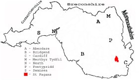
This diagram shows the position of this parish within the county of Glamorgan - click on this to see a full size diagram of the county
|
Parish map (Kain/Oliver)
You can see maps centred on OS grid reference ST115776 (Lat/Lon: 51.490275, -3.276157), St Fagans which are provided by:
- OpenStreetMap
- Google Maps
- StreetMap (Current Ordnance Survey maps)
- OpenStreetMap Cymru (Welsh counties only)
- Bing (was Multimap)
- Old Maps Online
- National Library of Scotland (Old Ordnance Survey maps)
- Vision of Britain (Click "Historical units & statistics" for administrative areas.)
- Magic (Geographic information) (Click + on map if it doesn't show)
- GeoHack (Links to on-line maps and location specific services.)
- All places within the same township/parish shown on an Openstreetmap map.
- Nearby townships/parishes shown on an Openstreetmap map.
- Nearby places shown on an Openstreetmap map.
Places, villages, farms etc within St Fagans parish as shown on the online parish map from the CD of Historic Parishes of England and Wales: an Electronic Map of Boundaries before 1850 with a Gazetteer and Metadata [computer file]. (Kain, R.J.P., Oliver, R.R.). (Extracted by Gareth Hicks)
- St Fagans (143); Castle; Croft-y-genau; Culver Ho.; Great Western Ry.; Llanfair-fach; Llanmaes; Llwyn-yr-eos; Mill; Old Windmill; Pentre-banau; Rhyd-lafar Cross Roads; St Fagans (village); Stockland; Tre-gyrnog; Tynewydd; Viaducts
The Population of St Fagans was as follows, and a more detailed breakdown is available.
| 1841 - 424 | 1851 - 515 | 1861 - 506 | 1871 - 536 | 1881 - 483 | 1891 - 490 |
Details of extant records on Archives Network Wales for the following;
- St Fagans Civil Parish records " ..... comprising copy of tithe plan and apportionment, 1840 [copied 1980]; assistant overseer's rate book, 1926; assistant overseer's receipt and payment book, 1906-1927; parish council minutes book, 1894-1967"