
Hide
St Mary Hill
hide
Hide
hide
Hide
hide
Hide
Hide
"MARY (ST.) HILL, a parish in the hundred of OGMORE, county of GLAMORGAN, SOUTH WALES, 4 miles (N. W.) from Cowbridge, containing 257 inhabitants. This parish, which lies in the south-eastern portion of the county, and on the left bank of the river Ewenny, derives its name from the dedication and elevated situation of the parish church. It is not of any great extent, but within its limits is comprised a portion of the lordship of Ruthin, though locally in the hundred of Cowbridge, ....................The living is a discharged rectory, in the archdeaconry and diocese of Llandaf, ..................... in the patronage of Sir John Aubrey, Bart. The church, dedicated to St. Mary, is situated on the brow of a lofty hill near the left bank of the river Ewenny; and from the churchyard, which is kept in fine order, are some beautiful and richly varied prospects to the north-east. ..............." ( A Topographical Dictionary of Wales by Samuel Lewis 1833)
Hide
Here is a substantial reading list of books which relate to Glamorgan, either county or parish.
The Glamorgan Family History Society have produced a set of microfiche containing Monumental Inscriptions for the following burial grounds :-
- Parish Church of St. Mary
| St Mary, St Mary Hill |
| St Mary, Penymynydd |
- Ruthin Chapel, St Mary Hill, Bridgend, records "Ruthin Chapel, originally built as a schoolroom for Salem Chapel, Pencoed, was opened in 1890. As a result of its convenient location it became a Chapel of Ease for the Methodists living in Mynydd Ruthin and its vicinities. Although later recognised as a church in its own right, it was always linked with Salem in that it shared the same ministry. Salem, Mynydd Ruthin and Soar Rhiwceiliog united as a pastorate in 1957. The chapel was closed in 1992"
"........comprising Sunday School register, 1973-1983, Sunday School account book, 1973-1984, account book, 1985-1988, members' contribution books, 1942-1984, and Superintendent Registrars' certificate, 1955." Archives Network Wales
For full and up-to-date details of their holdings see the sites of Glamorgan Record Office and/or West Glamorgan Archives
See Bap/Mar/Bur data on FreeReg
The church is dedicated to St. Mary, and is in the Benefice of Coychurch with Llangan and St. Mary Hill. Details of the present incumbent of this benefice can be found at the Church in Wales website. The church can be located at grid reference SS957793.
A transcription of the registers is available from the Glamorgan Family History Society for the years: Baptisms, 1696-1985, Marriages, 1696-1837, Burials, 1696-1837.
| Anglican Parish Registers Held at the Glamorgan Record Office, Cardiff | ||||
| Baptisms | Marriages | Burials | Banns | Bishops Transcripts |
| 1738-1985 | 1741-1970 | 1741-1811, 1813-1985 | - | 1696, 1721, 1723-1727, 1729-1746, 1748-1749, 1751-1837 |
Details of extant records on Archives Network Wales for the following;
- St Mary Hill Ecclesiastical Parish records " .......... including registers of baptisms, 1738-1985; marriages, 1741-1970; burials, 1741-1985; burial certificates, 1908-1965; churchwardens records, 1884-1927; civil records, 1848-1884"
The following Religious Institutions are covered in the Mormon International Genealogical Index (IGI) :-
- St. Mary Hill, St. Mary - Christenings (BT's), 1696-1860
Various landscapes - on the People's Collection Wales site
Transcript of name listing for Bridgend and district, from Slaters Directory for 1880.
The transcription of the section for St Mary Hill from The National Gazetteer (1868) provided by Colin Hinson.
Description of parish from A Topographical Dictionary of Wales (1833) by Samuel Lewis.
- Ask for a calculation of the distance from St Mary Hill to another place.
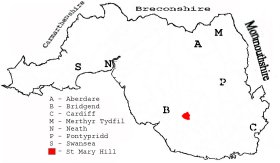
This diagram shows the position of this parish within the county of Glamorgan - click on this to see a full size diagram of the county
|
Parish map (Kain/Oliver)
You can see maps centred on OS grid reference SS961793 (Lat/Lon: 51.502811, -3.498287), St Mary Hill which are provided by:
- OpenStreetMap
- Google Maps
- StreetMap (Current Ordnance Survey maps)
- OpenStreetMap Cymru (Welsh counties only)
- Bing (was Multimap)
- Old Maps Online
- National Library of Scotland (Old Ordnance Survey maps)
- Vision of Britain (Click "Historical units & statistics" for administrative areas.)
- Magic (Geographic information) (Click + on map if it doesn't show)
- GeoHack (Links to on-line maps and location specific services.)
- All places within the same township/parish shown on an Openstreetmap map.
- Nearby townships/parishes shown on an Openstreetmap map.
- Nearby places shown on an Openstreetmap map.
Places, villages, farms etc within St Mary Hill as shown on the online parish map from the CD of Historic Parishes of England and Wales: an Electronic Map of Boundaries before 1850 with a Gazetteer and Metadata [computer file]. (Kain, R.J.P., Oliver, R.R.). (Extracted by Gareth Hicks)
- St Mary Hill (105); Broadway; Camp; Cross; Cwrt; Ewenny fach; Fair ground; Gelli-garn; Hen-dafarn?; Hen-efail; Heol-gareg; Llidiard-mawr; Mill; Mynydd Ruthin; Pantruthin-fach; Pantruthin-fawr; Pedair-onen; Persondy; Ruthin; St Mary Hill; St Mary Hill Down; Tan-y-lan; Tyle-gwyn; Ty'n-y-caeau; Ty'n-y-crofft;
There are many references to this area in the 15 million Welsh and English language articles from Welsh newspapers transcribed by the NLW and viewable on Welsh Newspapers Online
Below are English language articles that have been re-transcribed and extracted randomly to illustrate what is available, there are many that are not extracted here that include names of local people
- From the South Wales Daily News (Third Edition) 28th August 1899
ST. MARY HILL FAIR. This popular fair was held on Saturday, and contrary to tradition the weather was exceedingly fine. Good cart horses were in excellent demand, and hacks also sold well; but inferior quality was not sought after. Mr Griffiths, of Coity, sold a cart horse for 80 guineas, and Mr Davies, of Ewenny, disposed of two cart colts for £ 94—very satisfactory prices. The trade in cattle was not brisk, owing no doubt to the shortness of feed, consequent upon the dry weather. The attendance, was large, and there was the usual booths, &c.
- From The Glamorgan Gazette 8th February 1907
ST. MARY HILL. Concert.—A very successful concert was held at St. Mary Hill on January 30th, the proceeds being for providing prizes for the most regular scholars attending the day school. The Rev. W. A. Edwards occupied the chair, and as usual performed his duties in a happy way. The programme was a long one, and every item was carried out in a praiseworthy manner. .....(part extract).....
- From The Glamorgan Gazette 19th April 1918
ST. MARY HILL. Cattle Ploughing.—A spectacle, if not new under the sun, certainly new to the present generation of people, was witnessed at the beginning of this week at that well-tilled and excellently kept farm, Rythyn Fawr, where the esteemed Mr. Daniel Jenkins, one of the best agriculturists in all the kingdom, resides. Mr. Jenkins, like many other large farmers nowadays, is short of horses, and, to make up for the deficiency, he has resolved to fall back on the old-world custom of utilising cattle for ploughing. A powerful bull, yolked to a stalwart ox, were seen gently ploughing land for barley and turnips, early this week, and Mr. Jenkins now only requires a sweet singer and a liberal supply of "Tribannan Morganwg," which "Cadrawd" will no doubt be delighted to provide, to enable him to demonstrate effectively. how our fore- fathers did a great deal of excellent work to the accompaniment of sweet music.
The Population of St. Mary Hill was as follows, and a more detailed breakdown is available.
| 1841 - 258 | 1851 - 247 | 1861 - 252 | 1871 - 192 | 1881 - 171 | 1891 - 177 |
Details of extant records on Archives Network Wales for the following;
- St Mary Hill Civil Parish records " ......... comprising tithe plan and apportionment, 1844"