
Hide
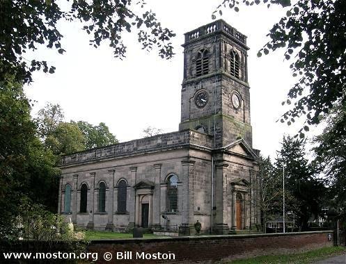
Christ Church, Alsager, Church of England
hide
Hide
Hide
Christ Church,
Church Road,
Alsager
Hide
Built in 1789 as a chapel to Barthomley: St. Bertoline. In 1852 it became the district church for the township of Alsager (previously served by Barthomley: St. Bertoline), and its boundaries were described in the London Gazette on 20 August 1852:
"The district chapelry of Alsager is bounded on the west by the townships of Barthomley and Haslington, in the said parish of Barthomley, on the north-west by the township of Hassall, in the parish of Sandbach, on the north-east by the township of Betchton, in the said parish of Sandbach, on the east by the parish of Church Lawton, and on the south by the parish of Audley"
This district was abolished on 19 July 1898 by the creation of the district of Alsager: St. Mary Magdalene, in which Christ Church served as a chapel of ease. In 1946 Christ Chuch became a district church for part of the township of Alsager. The boundaries of "The New Parish of Saint Mary Magdalene, Alsager" were described in the London Gazette on 9 August 1946:
"All that portion of the parish of Saint Mary Magdalene, Alsager, which is bounded upon part of the west and upon the north and north-east by the parish of Sandbach, upon the remaining part of the west by the parish of Haslington, upon the south-west by the parish of Barthomley, upon the south by the parish of Audley, in the diocese of Lichfield, and upon the remaining sides, that is to say, upon the east and north-east by an imaginary line commencing at a point where the footpath leading from Audley Road crosses Audley Brook on the boundary which divides the said parish of Audley from the said parish of Saint Mary Magdalene, Alsager and extending thence in a northerly direction, along the middle of the said Brook to a point where it crosses the public footpath leading through Bankhouse Farm to Brookhouse Farm .and extending thence eastwards and then northwards along the middle of the last mentioned footpath to its junction with the northeastern corner of Brookhouse Farm and extending thence northwards in a straight imaginary line crossing the London Midland and Scottish Railway to a point where such imaginary line joins the private road commonly known as the Cinder Path and extending thence northwards to and along the middle of the said path to its junction with Station Road land extending thence fiiist north-eastwards to and then north-westwards along the middle of the last mentioned road to its junction with Crewe Road and extending thence in the same direction to a point in the middle of the last mentioned road opposite to the south-western end of the eastern wall or fence belonging to the house No. 85 Crewe Road and extending thence northwards to and along the last mentioned wall or fence to its northern end, and junction with, the pond known as The Mere and extending thence along the south-western, western and north-western sides of the said pond to its junction with the southern end of the eastern wall or fence belonging to the property known as The Wood, Sandbach Road, and extending thence northwards along the last mentioned wall or fence to its junction with Sandbach Road and extending thence first northwards to and then north-westwards along the middle of the last mentioned road to a point one chain distant 'from its junction with Lodge Road and extending thence generally first north-eastwards and then northwards along the eastern walls or fences of the houses on the eastern side of Cresswallshawe Road for a distance of 32 chains to the boundary which divides the said parish of Sandbach from the said.parish of Saint Mary Magdalene, Alsager."
The district was affected by the following boundary change:
- 1952 October 24 — enlarged when the following area was transferred from Haslington: St. Matthew: "All that part of the parish of Haslington which is bounded upon the southwest by the parish of Crewe, upon the south by the parish of Barthomley, upon the east by the parish of Christ Church, Alsager, upon the north by the parish of Christ Church, Wheelock, and upon the remaining side by an imaginary line commencing at a point in the middle of the road leading to Bridgehouse Farm on the boundary which divides the parish of Christ Church, Wheelock, from the parish of Haslington and extending thence southeastwards along the middle of the last mentioned road to a point opposite to the middle of the footpath leading to Moss Cottage and continuing thence southwestwards to and along the middle of the said footpath for a distance of 25 chains to its junction with the footpath leading to Haslington Hall and continuing thence first southeastwards along the middle of the last mentioned footpath for a distance of 19 chains and then southwestwards for a distance of 22 chains to a point opposite to the middle of the footpath and road leading to Homeshaw Lane and continuing thence first southeastwards to and along the last mentioned footpath and road and thence southwestwards to a point opposite to the middle of Homeshaw Lane and continuing thence first to and then westwards along the middle of the last mentioned lane to a point opposite to the middle of the road leading to Butterton Lane and continuing thence southwards to and along the middle of the last mentioned road (thereby passing east of Butterton Lane Farm) and then in a straight line across the last mentioned road to the (boundary which divides the parish of Haslington from the parish of Crewe".
The district includes Oakhanger: St. Luke
C = Christenings (Baptisms) ; M = Marriages ; B = Burials ; BTs = Bishop's Transcripts
| Original Registers | C 1789-1889 ; M 1852-1868 ; B 1789-1908 — Cheshire Archives (P 278) C from 1890 ; M from 1947 ; B from 1908 — Church |
| Microfilm Copies | C 1789-1889 ; M 1852-1868 ; B 1789-1908 — Cheshire Archives |
| Bishop's Transcripts | 1789-95, 1789-1801, 1813-18, 1820-42 — Cheshire Archives (microfilmed) |
| Copies and Indexes | C 1789-1889 ; M 1852-1868 ; B 1789-1791, 1813-1908 (transcript by C. D. Jones, 5 vols.) — Cheshire Archives ; Alsager Library M 1852-1868, 1947-1998 — Cheshire BMD (CC:1004) |
| Monumental Inscriptions | C. D. Jones, 1989 (2 vols.) — Cheshire Archives |
| Notes | M 1868-1947 — see Barthomley: St. Bertoline or Alsager: St. Mary Magdalene |
- OpenStreetMap
- Google Maps
- StreetMap (Current Ordnance Survey maps)
- Bing (was Multimap)
- Old Maps Online
- National Library of Scotland (Old Ordnance Survey maps)
- Vision of Britain (Click "Historical units & statistics" for administrative areas.)
- English Jurisdictions in 1851 (Unfortunately the LDS have removed the facility to enable us to specify a starting location, you will need to search yourself on their map.)
- Magic (Geographic information) (Click + on map if it doesn't show)
- GeoHack (Links to on-line maps and location specific services.)