
Hide
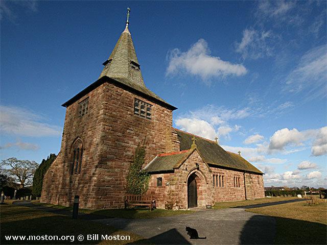
St Wenefrede, Bickley, Church of England
hide
Hide
Hide
St Wenefrede,
St Wenefredes Green,
Bickley
Hide
It was founded in 1892.
Bickley Moss
Church History
Founded in 1893 as the district church for the township of Cholmondeley, and parts of the townships of Bickley, Chorley, Norbury, and Wrenbury cum Frith (previously served by Malpas: St. Oswald, Marbury: St. Michael and Wrenbury: St. Margaret). The boundaries of "The Consolidated Chapelry of Saint Wenefrde, Bickley" were described in the London Gazette on 3 February 1893:
"I. All that portion of the parish of Malpas in the county of Chester and in the diocese of Chester which is comprised within and is co-extensive with the whole of the township of
Cholmondeley and that part of the township of Bickley which is not included within the limits of the new parish of Saint Chad Malpas in the same county and diocese""II. And also all that contiguous portion of the parish of Marbury in the same county and diocese which is hounded upon the west upon the north-west and upon the north by the above-described portion of the parish of Malpas aforesaid upon part of the south-east and upon the north-east by the firstly hereinafter described portion of the parochial chapel of Wrenbury in the county and diocese aforesaid and upon the remaining sides, that is to say upon the remaining part on the south-east and upon the south-west by an imaginary, line commencing upon the boundary which divides the said parochial chapelry of Wrenbury from the parish of Marbury aforesaid at a point near Holtridge in the middle of the road which leads from Wrenbury past Lean Acres Farm, Holtridge, and Swanwick Green, into the main road leading from Tarporloy to Whitchurch at which point the first-mentioned road is joined by the footpath leading to Frith Hall Farm and the Shoprshire Union Canal and extending thence first south-westward and then north-westward along the middle of the said first-mentioned road for a distance-of one mile and twenty-nine chains or thereabouts to the boundary which divides the said parish of Marbury from the above described portion of the parish of Malpas aforesaid."
"III. And also all that contiguous portion of the said parochial chapelry of Wrenbury which is bounded upon the north by the above described portion of the parish of Malpas aforesaid upon the north-west and upon the south-west, by the above described portion of the parish of Marbury aforesaid, and upon the remaining sides that is to say upon the south-east and upon the north-east by an imaginary line commencing upon the boundary which divides the said parish of Marbury from the parochial chapelry of Wrenbury aforesaid at the said point near Holtridge in the middle of the lastly-mentioned road at its junction with the said footpath leading to Frith Hall Farm and the Shropshire Union Canal as aforesaid and extending thence that is to say from the last mentioned point noith-eastward along the.middle of the-said lastly-mentioned road for a distance of eighteen chains or thereabouts to its junction with the road which leads past Parkside Farm to Chorley and extending thence north-westward along the middle of the last-mentioned road for a distance of twenty-five and a half chains or thereabouts to the-point where the.same road crosses the stream flowing from Cholmondeley Meres into the river Weaver, and where the boundary which divides the said parochial chapelry of Wrenbury from the above-described-portion of the parish of Marbury aforesaid, joins the boundary dividing the said parochial chapelry of Wrenbury from
the parish of Malpas aforesaid"."IV. And also all that other contiguous portion of the said parochial.chapelry of Wrenbury which is bounded upon the south-west, upon the west and upon the north-west by the above described portion of the parish of Malpas aforesaid, upon the northeast by the parish of Acton in the county and diocese aforesaid, and upon the remaining sides that is.to say upon the east and upon the south by an imaginary line commencing upon the boundary which divides the said parish of Acton from the parochial chapelry of Wrenbury aforesaid at a point in the middle of the road which leads from Larden Green to Chorley and extending thence south-westward along the middle of the last-mentioned road for a distance of seventeen chains or thereabouts to its junction with the road and footpath which lead past Brook House and Chorley Hall to the farmhouse called or known as Frith Farm and extending thence generally southward along the middle of the said road and footpath for a distance of one mile and seven chains or thereabouts to the centre of the bridge or culvert which carries such footpath over the River Weaver aforesaid and extending thence first generally north-westward and then generally south-westward along the middle of the said river for a distance of one mile and thirteen chains or thereabouts (thereby following the boundary which divides the township of Chorley from the township of Wrenbury-cum-Frith both in the said parochial chapelry of Wrenbury) to the boundary at the point where the said River Weaver is joined by the stream flowing from Cholmondeley Meres as aforesaid which boundary divides the said parochial chapelry of Wrenbury from the above-described portion of the parish of Malpas aforesaid."
Church Records
C = Christenings (Baptisms) ; M = Marriages ; B = Burials ; BTs = Bishop's Transcripts
| Original Registers | C 1892-1983 ; M 1893-1984 ; B 1892-1985 — Cheshire Archives (P 228) C from 1965 ; M from 1984 ; B from 1985 — Church |
| Bishop's Transcripts | 1892-1894 (microfilmed) — Cheshire Archives |
| Copies and Indexes | M 1893-1958 — Cheshire BMD (CW:CE5) |
- OpenStreetMap
- Google Maps
- StreetMap (Current Ordnance Survey maps)
- Bing (was Multimap)
- Old Maps Online
- National Library of Scotland (Old Ordnance Survey maps)
- Vision of Britain (Click "Historical units & statistics" for administrative areas.)
- English Jurisdictions in 1851 (Unfortunately the LDS have removed the facility to enable us to specify a starting location, you will need to search yourself on their map.)
- Magic (Geographic information) (Click + on map if it doesn't show)
- GeoHack (Links to on-line maps and location specific services.)