
Hide
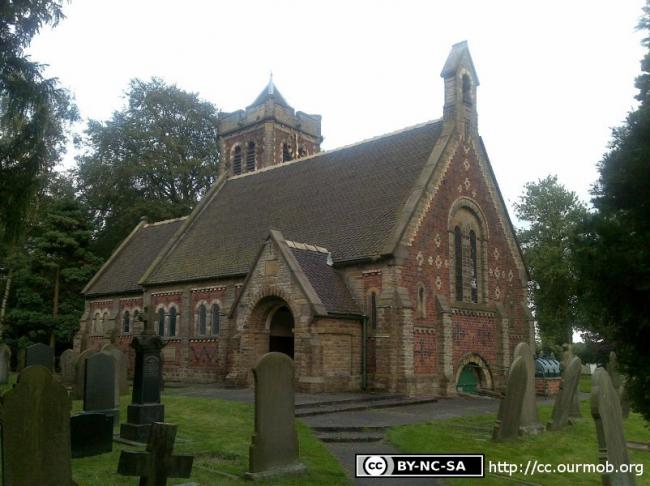
St John the Evangelist, Byley, Church of England
hide
Hide
Hide
St John the Evangelist,
Moss Lane,
Byley
Hide
It was founded in 1846.
Also known as: Biley: St. John.
Off Delamere Street
Church History
Founded in 1848 as the district church for the townships of Leese and Stublach, and parts of the townships of Byley, Cranage, Kinderton cum Hulme, Rudheath and Sproston (previously served by Davenham: St. Wilfrid, Middlewich: St. Michael & All Angels, Sandbach: St. Mary and Church Hulme: St. Luke). The boundaries of "The Consolidated Chapelry of Biley" [sic] were described in the London Gazette on 25 April 1848:
"The boundary commences at the centre of a bridge, called Byleybridge, over the river Dane and thence proceeding eastward up the middle of the said river tilll it reaches a point near Low's-pool, where the townships of Leese and Cranage meet; it then follows the boundary of the former township north eastward until it meets the road leading from Middlewich and Leese-smithy to Cranage; it then proceeds along the middle of that road eastward till it reaches another lane, called Mainwaring's-lane, otherwise Crow's-nest; it then proceeds up the middle of the last-mentioned lane northward and then eastward till it reaches the turnpike road leading from Hulme's Chapel to Krtutsford; it then proceeds northward along the middle of the said turnpike road to a point where the boundary of Cranage township crosses the said road, it then takes a north westerly, south westerly, south easterly, and again a south westerly and north westerly direction, following the boundary of Cranage township; through all its points, until it arrives at the point where the said boundary meets the boundary of Rudheath lordship, which last-mentioned boundary it follows in a nor th westerly direction till it meets the boundary of Stublach township in the parish of Middlewich, which last-mentioned boundary it follows nor th westerly and then south westerly and again north westerly, and then in a southerly direction till it comes to the boundary of Rudheath lordship, in the parish of Davenham; it then follows the last-mentioned boundary in a westerly direction until it comes to the north western corner of a field, now in the holding of Thomas Jepson, of Drakelow-farm, No. .84, on the tithe commutation map of the said parish of Davenham; thence proceeding southward along the western boundary of the said field, and also along the western boundary of the field, No. 68, on the said map, leaving the house and premises of Drakelow-farm on the east, within the proposed consolidated chapelry, and still proceeding southward along the western and southern boundaries of the field, No. 70, on the said map, easterly and along the western boundary of fields, Nos. 73 and 74, on the said map, all in the holding of the said Thomas Jepson; and thence following the southern boundary of the field, No. 74, on the said map, easterly till it reaches a field, No. 110, on the said map, now in the holding of Samuel Sherwin, of Brown Heys Farm; it then follows the western boundary of the said field, No. 110, and also of the fields, Nos. 112 and 113, on the said map, in the holding of the said Samuel Sherwin, and comes to the point where the boundary of the said last-mentioned field, No. 113, reaches the boundary of the said township of Byley cum Gatehouse, in the said parish of Middlewich; it then proceeds in a south westerly course along the boundary of the said township of Byley cum Gatehouse, which boundary it continues to follow southerly and south easterly, through all its points, until it reaches the bridge over the river Dane, called Byley-bridge, to the point in the middle of the said bridge, at which the boundary of the said proposed consolidated chapelry commenced"
The district was affected by the following boundary change:
- 1909 October 22 — enlarged when the following part of the township of Allostock was transferred from Lower Peover: St. Oswald: "All that portion of the parish of Lower Peover, in the said county and diocese, which is bounded upon the west partly by two detached portions of the parish of Great Budworth, and partly by the new parish of Saint John the Evangelist, Lostock Gralam, both in the said county and diocese, upon the south-west partly by the last-named new parish and partly by the said new parish of Biley, otherwise Byley, upon the south by the said new parish of Bitey, otherwise Byley, and upon the remaining sides, that is to say, upon the east, upon the north-east, and upon the north, by an imaginary line commencing at the point in the middle of the road leading from Holmes Chapel to Knutsford, where the boundaries of the said new parish of Biley, otherwise Byley, the parochial chapelry of Church Hulme, in the said county and diocese, and the said parish of Lower Peover all meet, and extending thence first northward along the middle of the said road for a distance of thirty-four chains and a half or thereabouts to its junction with Wash-lane, and extending thence first westward and then northwestward along the middle of the said Wash-lane for a distance of seventy-six chains or thereabouts to its junction with the road leading from Middlewich to Knutsford and with the lane leading to Hulme Hall and extending thence first north-westward and then westward along the middle of the lane leading to Hulme Hall for a distance of thirty-six chains or thereabouts to its junction with the footpath leading to Lach Dennis, and extending thence westward along the middle of the said footpath for a distance of forty-six chains or thereabouts to the point opposite to the place where the boundary which divides the said parish of Lower Peover from one of the detached portions of the said parish of Great Budworth commences to follow the fence on the southern side of the said footpath, and extending thence southward in a straight line to the said boundary."
Church Records
C = Christenings (Baptisms) ; M = Marriages ; B = Burials ; BTs = Bishop's Transcripts
| Original Registers | C 1848-1906 ; M 1864-1972 ; B 1849-1898 — Cheshire Archives (P 100) C from 1906 ; M from 1973 ; B from 1899 — Church |
| Microfilm Copies | C 1848-1906 ; M 1864-1972 ; B 1849-1898 — Cheshire Archives ; Family History Society of Cheshire C 1848-1906 ; B 1849-1898 — Sandbach Library |
| Bishop's Transcripts | 1855-60, 1881-93 (microfilmed) — Cheshire Archives, Family History Society of Cheshire |
| Copies and Indexes | M 1864-1974 — Cheshire BMD (CW:110) |
| Monumental Inscriptions | South Cheshire Family History Society, 1998 |
- OpenStreetMap
- Google Maps
- StreetMap (Current Ordnance Survey maps)
- Bing (was Multimap)
- Old Maps Online
- National Library of Scotland (Old Ordnance Survey maps)
- Vision of Britain (Click "Historical units & statistics" for administrative areas.)
- English Jurisdictions in 1851 (Unfortunately the LDS have removed the facility to enable us to specify a starting location, you will need to search yourself on their map.)
- Magic (Geographic information) (Click + on map if it doesn't show)
- GeoHack (Links to on-line maps and location specific services.)