
Hide
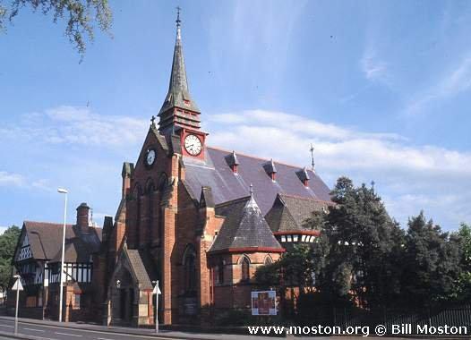
St Paul, Chester, Church of England
hide
Hide
Hide
St Paul,
Boughton Lane,
Chester
Hide
It was founded in 1875.
Boughton Lane
Church History
Founded in 1838 as a chapel to Chester: St. John the Baptist. In 1846 it became the district church for the townships of Great Boughton and Spital Boughton, and part of the city of Chester (previously served by Chester: St. John the Baptist and Chester: St. Oswald). The boundaries of "The Consolidated Chapelry of Saint Paul, Chester" were described in the London Gazette on 10 July 1846:
"The consolidated chapelry of Saint Paul, Chester, is to consist of the township of Great Boughton (being an out-township and part of the said parish of Saint Oswald) and a portion of the said parish of Saint John the Baptist, including Spital Boughton; the part taken from the said parish being bounded on the north by the Ellesmere and Chester Canal; on the east by the said township of Great Boughton; on the south by the river Dee, and on the west by Stephen-street, the east side of which is included in the said consolidated chapelry, and then by a liine passing from the end of Stephen-street, across Foregate-street, to the west of a public-house known by the sign of the Coach and Horses; and thence by an imaginary line drawn in a southerly direction through Mr. Baxter's grounds to the river Dee. The part taken from the said parish of Saint Oswald, and called the township of Great Boughton, as aforesaid, being bounded on or towards the north by the parish of Plemstall; on the west by the respective parishes of Plemstall, Saint John the Baptist, and Saint Bridget; and on the south and east by the respective parishes of Guilden Sutton, Christleton, and a part of the said parish of Saint Oswald"
The district was affected by the following boundary changes:
- 1879 August 22 — enlarged when the following area was transferred from Chester: St. John the Baptist: "All that portion of the parish of Saint John the Baptist Chester in the city county and diocese aforesaid wherein the present incumbent of such parish now possesses the exclusive cure of souls which is bounded on the north by the district chapelry of All Saints Hoole in the said county of Chester and in the diocese aforesaid on the east and on the south by the new parish of Saint Paul Chester aforesaid and on the remaining side that is to say on the west by an imaginary line commencing upon the boundary which divides the said new parish of Saint Paul Chester from the parish of Saint John the Baptist Chester aforesaid at the middle of the southern end of the bridge which carries Hoole-lane over the Shropshire Union Canal at Hoole-lane Lock and extending thence first northward and then eastward along the middle of the said lane for a distance of two and a quarter chains or thereabouts to its junction with the road which leads past the houses called or known as Station View to New Peploe-street and extending thence northward along the middle of the said road for a distance of twelve chains or thereabouts (thereby passing to the west.of the houses called or known as Station View aforesaid and crossing over the line of the London and North Western Railway) to the boundary at the culvert whereby the stream called or known as Flooker's Brook passes under the same road which boundary divides the said parish of Saint John the Baptist Chester from the district chapelry of All Saints Hoole aforesaid)"
- 1934 August 17 — enlarged when the following area was transferred from Plemstall: St. Peter: "All those portions of the said Parish of Plemstall which lie to the south-west of the Parish of Guilden Sutton, in the said County and Diocese, and to the south-east of the middle of the said Chester and Warrington Line of Railway".
- 1934 August 17 — enlarged when the following area was transferred from Hoole: All Saints: "All that portion of the said New Parish of All Saints, Hoole, which lies to the south-east of the middle of the said Chester and Warrington Line of Railway".
- 1934 August 17 — reduced when an area was transferred to Hoole: All Saints.
Church Records
C = Christenings (Baptisms) ; M = Marriages ; B = Burials ; BTs = Bishop's Transcripts
| Original Registers | C 1838-1985 ; M 1874-1990 — Cheshire Archives (P 162) C from 1985 ; M from 1990 — Church |
| Microfilm Copies | C 1838-1933 ; M 1874-1947 — Cheshire Archives C 1838-1919 ; M 1874-1934 — Manchester Archives & Local Studies ; Family History Society of Cheshire |
| Copies and Indexes | M 1874-1958 — Cheshire BMD (CW:CE16) |
| Bishop's Transcripts | 1838-1870 (microfilmed) — Cheshire Archives ; Family History Society of Cheshire |
| Notes | B — none |
- OpenStreetMap
- Google Maps
- StreetMap (Current Ordnance Survey maps)
- Bing (was Multimap)
- Old Maps Online
- National Library of Scotland (Old Ordnance Survey maps)
- Vision of Britain (Click "Historical units & statistics" for administrative areas.)
- English Jurisdictions in 1851 (Unfortunately the LDS have removed the facility to enable us to specify a starting location, you will need to search yourself on their map.)
- Magic (Geographic information) (Click + on map if it doesn't show)
- GeoHack (Links to on-line maps and location specific services.)