
Hide
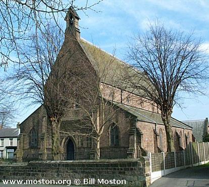
St James the Great, Congleton, Church of England
hide
Hide
Hide
St James the Great,
West Street/Astbury Street,
Congleton
Hide
It was founded in 1847.
West Street.
Church History
Built in 1844 as the district church for part of the township of Congleton (previously served by Congleton: St. Peter and Astbury: St. Mary). The boundaries of "The District of Saint James, Congleton" were described in the London Gazette of 10 July 1844:
"All that part of the chapelry of Saint Peter, Congleton, in the parish of Astbury, in the county and diocese of Chester, situate on the western side of an imaginary line extending eastward, along the river Dane as far as the bridge, over such river, at the northern end of Mill-street, and thence southward, along the middle of such street, and the street called Swan-bank, Wagg-street, Wagg-lane, and Stony-lane, as far as the boundary of the township of Newbold Astbury, in the same county."
Church Records
C = Christenings (Baptisms) ; M = Marriages ; B = Burials ; BTs = Bishop's Transcripts
| Original Registers | C 1844-1957 ; M 1849-1980 — Cheshire Archives (P 210) C from 1957 ; M from 1980 — Church |
| Microfilm Copies | C 1844-1957 ; M 1849-1947 — Cheshire Archives C 1844-1901 ; M 1849-1908 — Family History Society of Cheshire ; Congleton Library |
| Bishop's Transcripts | 1886-1894 (microfilmed) ; 1904-1919 — Cheshire Archives |
| Copies and Indexes | M 1849-2000 — Cheshire BMD (CE:1026) |
| Notes | B — none |
- OpenStreetMap
- Google Maps
- StreetMap (Current Ordnance Survey maps)
- Bing (was Multimap)
- Old Maps Online
- National Library of Scotland (Old Ordnance Survey maps)
- Vision of Britain (Click "Historical units & statistics" for administrative areas.)
- English Jurisdictions in 1851 (Unfortunately the LDS have removed the facility to enable us to specify a starting location, you will need to search yourself on their map.)
- Magic (Geographic information) (Click + on map if it doesn't show)
- GeoHack (Links to on-line maps and location specific services.)