
Hide
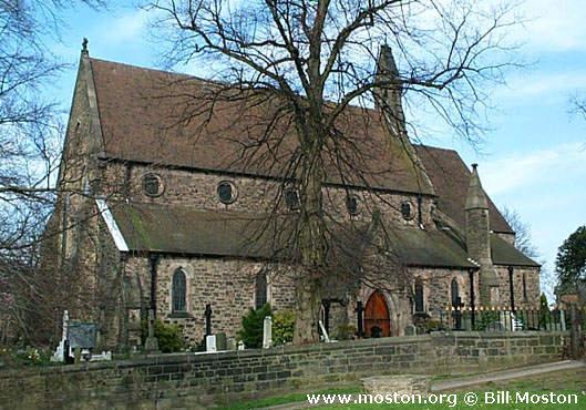
St Stephen, Congleton, Church of England
hide
Hide
Hide
St Stephen,
Brook Street,
Congleton
Hide
It was founded in 1858.
Brook Street.
Church History
Built in 1845 as the district church for part of the township of Congleton (previously served by Congleton: St. Peter and Astbury: St. Mary). The boundaries of "The District of Saint Stephen's, Congleton" were described in the London Gazette on 1 August 1845:
"All that part of the township of Congleton, in the parish of Astbury, and in the county and diocese of Chester, situate on the north eastern side of an imaginary line commencing at a point (marked a on the map or plan herewith) on the southern bank of the river Dane, opposite to the middle of Kinsey-street, and thence extending southward along the middle of such street to a point (marked b as aforesaid) opposite to the middle of Lawton-street, and thence eastward along the middle of such last-mentioned street to a point (marked c as aforesaid) opposite to the middle of the street or lane called Colehill-bank, and thence southward along the middle of such street or lane as far as the middle of Canal-street, and thence towards the south east along the middle of such last-mentioned street as far as the middle of the Macclesfield Canal, and on the north western side of an imaginary line extending along the middle of such canal."
Church Records
C = Christenings (Baptisms) ; M = Marriages ; B = Burials ; BTs = Bishop's Transcripts
| Original Registers | C 1844-1962 ; M 1860-1982 ; B 1860-1968 — Cheshire Archives (P 232) C from 1962 ; M from 1982 ; B from 1969 — Church |
| Microfilm Copies | C 1844-1860, 1896-1936 ; M 1850-1958 ; B 1860-1932 — Cheshire Archives ; Congleton Library |
| Copies and Indexes | M 1860-2008 — Cheshire BMD (CE:1028) |
- OpenStreetMap
- Google Maps
- StreetMap (Current Ordnance Survey maps)
- Bing (was Multimap)
- Old Maps Online
- National Library of Scotland (Old Ordnance Survey maps)
- Vision of Britain (Click "Historical units & statistics" for administrative areas.)
- English Jurisdictions in 1851 (Unfortunately the LDS have removed the facility to enable us to specify a starting location, you will need to search yourself on their map.)
- Magic (Geographic information) (Click + on map if it doesn't show)
- GeoHack (Links to on-line maps and location specific services.)