
Hide
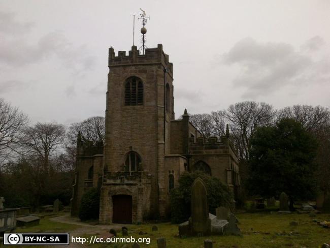
St Mary the Virgin, Disley, Church of England
hide
Hide
Hide
St Mary the Virgin,
Red Lane,
Disley
Hide
It was founded in 1558.
Red Lane.
Church History
An ancient chapel in the parish of Stockport: St. Mary the Virgin, which in 1913 became the district church for the township of Disley. The boundaries of "The District Chapelry of Saint Mary, Disley" were described in the London Gazette on 14 October 1913:
"All that part of the parish of Saint Mary in Stockport, in the county of Chester and in the diocese of Chester, which is comprised within, and is co-extensive with the ancient chapelry of Disley or, in other words, with the civil parishes of Disley and Newtown".
The district was affected by the following boundary changes:
- 1923 June 1 — enlarged when the following area was transferred from Taxal: St. James: "All that portion of the Parish of Taxal with Kettleshulme, in the said County and Diocese, which is bounded upon the south by an isolated portion of the Parish of Prestbury, in the same County and Diocese, upon the north west by the said New Parish of Saint Mary, Disley, upon part of the east by the New Parish of Chinley with Bugsworth, in the County of Derby and in the Diocese of Southwell, and upon the remaining sides, that is to say, upon the remaining part of the east and upon the south east by an imaginary line commencing upon the boundary which divides the said New Parish of Chinley with Bugsworth from the said Parish of Taxal with Kettleshulme at the centre of the bridge which carried the road leading from Bugsworth into the Buxton Road across the River Goyt, and extending thence westward along the middle of the first mentioned road for a distance of 4½ chains or thereabouts to the point where it diverges southward along the eastern side of the Stockport and Buxton Line of the London, Midland and Scottish Railway and extending thence first westward to the middle of the said line of railway and then southward along the middle of such line of railway for a distance in all of 21 chains or thereabouts to the centre of the culvert which carries such line of railway across the stream known as Ringstone Clough, and extending thence first westward and then generally south westward along the middle of Ringstone Clough for a distance of threequarters of a mile or thereabouts to the point where it meets the fence forming the south-eastern boundary of the Whaley Bridge Golf Course and also of the close numbered 57 upon the Ordnance Survey Map of the Civil Parish of Yeardsley cum Whaley published in the year 1909 upon the scale of 25 inches to a mile and also upon the map or plan which is annexed to this Scheme or Representation, and extending thence south westward along the said fence for a distance of 17 chains or thereabouts to the point where it meets the north-eastern side of the Buxton Old Road, and continuing thence south-westward and in a straight line across the Buxton Old Road for a distance of 15 yards or thereabouts to a point in the middle of the occupation road leading from the Buxton Old Road to the Stoneheads Reservoir, and extending thence south eastward along the middle of the said occupation road for a distance of 11 chains or thereabouts to a point opposite to the north-eastern end of the fence forming the south-eastern boundary of the close numbered 67 upon the said maps, and extending thence first south westward to and then first south westward, then westward and then again south westward along the last mentioned fence for a distance of 26½ chains or thereabouts to its south-western end upon the boundary which divides the said Parish of Taxal with Kettleshulme from the said isolated portion of the said Parish of Prestbury".
Church Records
C = Christenings (Baptisms) ; M = Marriages ; B = Burials ; BTs = Bishop's Transcripts
| Original Registers | C 1591-1962 ; M 1591-1980 ; B 1591-1958 — Cheshire Archives (P 69) C from 1962 ; M from 1980 ; B from 1959 — Church |
| Microfilm Copies | C 1591-1962 ; M 1591-1964 ; B 1591-1958 — Cheshire Archives C 1591-1962 ; M 1591-1738, 1838-1964 ; M 1591-1958 — Manchester Archives & Local Studies C 1591-1962 ; M 1591-1750, 1838-1964 ; B 1591-1958 — Family History Society of Cheshire ; Macclesfield Library C 1591-1812 ; M 1591-1735, 1838-1964 ; B 1591-1812, 1813-1958 — Stockport Heritage Library |
| Bishop's Transcripts | 1604, 1619-23, 1664-85, 1689-92, 1694-95, 1697-1702, 1710, 1712-1802, 1804-57 (microfilmed) — Cheshire Archives |
| Copies and Indexes | CMB 1592-1727 (transcript) — Manchester Archives & Local Studies (Owen MSS) M 1596-1837 (incomplete) — Bertram Merrell Marriage Index of Cheshire (1750-1836) M 1591-1738 — published in: Cheshire Parish Registers: Marriages, vol. 1 (Phillimore, 1909) M 1651-1675, 1701-1750 — Boyd's Marriage Index - may be viewable at subscription sites such as ancestry and findmypast M 1651-1750 — North & East Cheshire Marriage Index - may be viewable at subscription sites such as ancestry or findmypast M 1838-1994 — Cheshire BMD (CE:1036) |
| Monumental Inscriptions | 1972 (partial) — Cheshire Archives Published by the Family History Society of Cheshire (edited by S. Marshall), 1976 Published by Disley Local History Society, 1994 — Cheshire Archives |
| Notes | CMB 1594-1604, 1633-1643 — not recorded M 1754-1837 — see Stockport: St. Mary the Virgin |
It is located at SJ9745384507 (Lat/Lon 53.357434, -2.039724). You can see this on maps provided by:
- OpenStreetMap
- Google Maps
- StreetMap (Current Ordnance Survey maps)
- Bing (was Multimap)
- Old Maps Online
- National Library of Scotland (Old Ordnance Survey maps)
- Vision of Britain (Click "Historical units & statistics" for administrative areas.)
- English Jurisdictions in 1851 (Unfortunately the LDS have removed the facility to enable us to specify a starting location, you will need to search yourself on their map.)
- Magic (Geographic information) (Click + on map if it doesn't show)
- GeoHack (Links to on-line maps and location specific services.)