
Hide
St John the Divine, Frankby, Church of England
hide
Hide
Hide
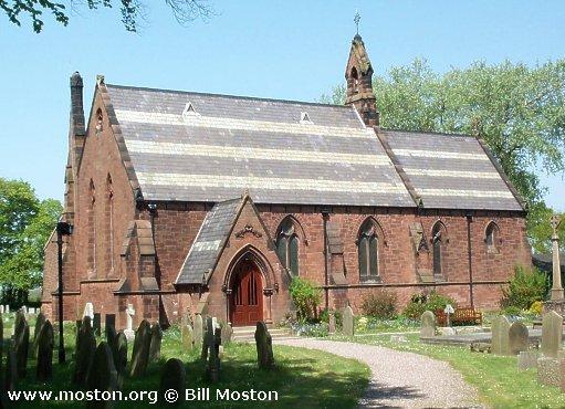
St John the Divine,
Frankby
Hide
It was founded in 1861.
Frankby Road
Church History
Founded in 1861 as a district church for the township of Frankby, and parts of the townships of Grange, Greasby and Newton cum Larton (previously served by West Kirby: St. Bridget). The boundaries of "The District of Frankby" were described in the London Gazette on 28 June 1861:
"All those portions of the parish of West Kirby, in the county of Chester and in the diocese of Chester, wherein the present incumbent of such parish how possesses the exclusive cure of souls, which are comprised within the townships of Frankby and Greasby within the said parish. And also all those portions of the said parish wherein such incumbent possesses the same cure of souls which are comprised within the several parts of the townships of Grange and Newton-cum-Larton, which are situate to the east of an imaginary line commencing at a point in the middle of the fence forming the eastern boundary of the township road leading from Thurstaston to Grange, where the boundaries of the said township of Frankby and of the township of Caldy in the same parish unite with the boundary of a detached portion of the said township of Grange, and opposite to a boundary-stone inscribed " F. D., 1861," placed on the eastern side of such fence, and extending thence north-westward along the middle of the same fence to its junction with the fence forming the eastern boundary of Cross otherwise Hinderton-lane, and extending thence north-eastward along the middle of the last-mentioned fence to its junction with the fence forming the southern boundary of Church-lane, and extending thence eastward along the middle of the last-mentioned fence as far as a point opposite to the middle of the southern extremity of the fence forming the eastern boundary of Newton-lane and Grange-lane respectively, and extending thence north-eastward in a direct line across Church-lane aforesaid to the middle of the southern extremity of the last-mentioned fence, and extending thence in the last-mentioned direction along the middle of the same fence to the road leading from Frank by to Grange, and thence crossing the said road and continuing along the middle of the fence forming the eastern boundary of the northern portion of Newton-lane and Grange-lane aforesaid to the road leading from the last-named lane to Larton and thence crossing the last-mentioned road leading to Larton, and continuing along the middle of the fence forming the eastern boundary of the last-mentioned portion of Newton-lane and Grange-lane aforesaid as far as a point in the same fence opposite to themiddle of the eastern end of the fence which divides the inclosiire numbered 20 upon the tithe commutation map of the said parish of "West Kirby, and upon the map hereunto annexed, from the inclosure numbered 168 upon the same maps, and extending thence north-westward in a direct line across Grange-lane to and along the middle of the last-mentioned fence to its junction with the fence which divides the inclosures numbered 20 as aforesaid and 19 upon the said maps from the inclosures numbered respectively 169 and 18 upon the same maps, and extending thence northward along the middle of such last-mentioned fence to n point in the middle of the road leading from Grange to Newton, and extending thence eastward along the middle of the last-mentioned road as far as a point opposite to the middle of the southern extremity of the fence which divides the inclosure numbered 15 upon the said maps from the inclosure numbered 16 upon the same maps, and extending thence northward to and along the middle of such fence to its junction with the fence dividing the two last-mentioned inclosures from the inclosures numbered respectively 172 and 173. npon the said maps, and extending thence northwestward along the middle of such last-mentioned fence to its point of junction with the fence dividing the inclosure numbered 173 as aforesaid from the inclosure numbered 171 upon the said maps, and extending thence northward along the middle of such last-mentioned fence to its junction with the fence dividing the inclosure numbered 173 as aforesaid from the inclosure numbered 174 upon the same maps, and extending thence eastward along the middle of the last-mentioned fence to its extremity, and continuing thence in the same direction and in a straight line across the small inclosure numbered 14 upon the said maps, ftud across the occupation road leading from Newton aforesaid to the Carrs to a point in the middle of the western extremity of the fence dividing the inclosure numbered 100 upon the said maps from the inclosure numbered 101 npon the same maps, and extending thence in a direction generally north-eastward along the middle of such lastmentioned fence and of the fences which divide the inclosures numbered respectively 103, 105, 106, and 204, upon the said maps from the inclosures numbered respectively 102, 187, 188, 107, 203, 111, and 112, upon the same maps to the point at which the fence dividing the inclosure numlbered 204 from the inclosure numbered 112 as aforesaid is joined by the fence dividing the inclosure numbered 201 upon the said maps from the aforesaid inclosure numbered 204, and extending thence eastward along the middle of such last-mentioned fence, and of the fences which divide the inclosures numbered respectively 119, 120, 121,122, and 123, upon the said maps from the inclosures numbered respectively 200, 199, and 198 upon the same maps, to a point in the middle of the road leading from Greasby to Hoylake, and extending thence northward along the middle of the last mentioned road as for as the boundary dividing the said parish of West Kirby from the parish of Bulstone in the same county and diocese."
The district was affected by the following boundary changes:
- 1937 October 26 — reduced when an area was transferred to Great Meols: St. John the Baptist.
The district included the Royal Air Force chapel of West Kirby: St. Paul.
Church Records
C = Christenings (Baptisms) ; M = Marriages ; B = Burials ; BTs = Bishop's Transcripts
| Original Registers | C from 1862 ; M from 1862 ; B from 1862 — Church |
| Microfilm Copies | C 1862-1963 ; B 1862-1983 — Cheshire Archives ; Manchester Archives & Local Studies ; Birkenhead Central Library ; Family History Society of Cheshire |
| Bishop's Transcripts | 1862-1908 (microfilmed) — Cheshire Archives |
| Copies and Indexes | C 1862-1941, 1946-1947 (transcript) — Cheshire Archives M 1862-1942 — Cheshire BMD (WR:BK66) |
- OpenStreetMap
- Google Maps
- StreetMap (Current Ordnance Survey maps)
- Bing (was Multimap)
- Old Maps Online
- National Library of Scotland (Old Ordnance Survey maps)
- Vision of Britain (Click "Historical units & statistics" for administrative areas.)
- English Jurisdictions in 1851 (Unfortunately the LDS have removed the facility to enable us to specify a starting location, you will need to search yourself on their map.)
- Magic (Geographic information) (Click + on map if it doesn't show)
- GeoHack (Links to on-line maps and location specific services.)