
Hide
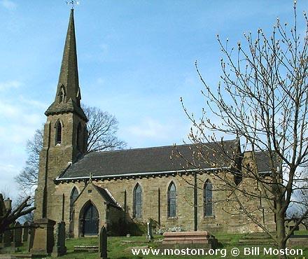
St Thomas, Henbury, Church of England
hide
Hide
Hide
St Thomas,
Church Lane, Henbury,
Henbury
Hide
It was founded in 1845.
Church History
Built in 1845 as the district church for the township of Henbury and part of the township of Macclesfield (previously served by Prestbury: St. Peter and Gawsworth: St. James).
The district was affected by the following boundary change:
- 1962 January 25 — (details not available)
- 1975 October 22 — reduced when part of the civil parish of Macclesfield was transferred to Upton Priory: Church of the Resurrection.
Church Records
C = Christenings (Baptisms) ; M = Marriages ; B = Burials ; BTs = Bishop's Transcripts
| Original Registers | C 1845-2012 ; M 1869-1988 ; B 1845-2006 — Cheshire Archives (P 253) C from 2012 ; M from 1988 ; B from 2006 — Church |
| Microfilm Copies | C 1845-1956 ; M 1869-1955 ; B 1845-1956 — Cheshire Archives C 1845-1872 — Family History Society of Cheshire ; Macclesfield Library |
| Bishop's Transcripts | 1892-1904 (microfilmed) — Cheshire Archives |
| Copies and Indexes | M 1869-1988 — Cheshire BMD (CE:1044) |
| Monumental Inscriptions | Published by the Family History Society of Cheshire (Macclesfield Group), 1990 |
It is located at SJ8817973626 (Lat/Lon 53.259499, -2.178657). You can see this on maps provided by:
- OpenStreetMap
- Google Maps
- StreetMap (Current Ordnance Survey maps)
- Bing (was Multimap)
- Old Maps Online
- National Library of Scotland (Old Ordnance Survey maps)
- Vision of Britain (Click "Historical units & statistics" for administrative areas.)
- English Jurisdictions in 1851 (Unfortunately the LDS have removed the facility to enable us to specify a starting location, you will need to search yourself on their map.)
- Magic (Geographic information) (Click + on map if it doesn't show)
- GeoHack (Links to on-line maps and location specific services.)