Hide
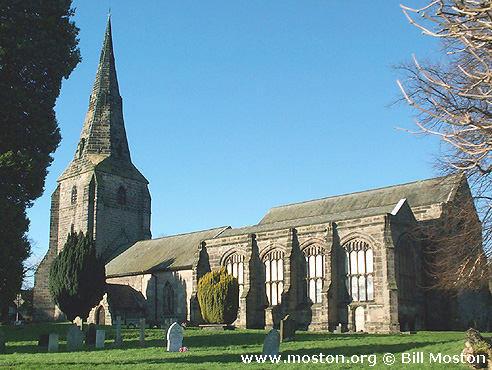
St Andrew, Bebington, Church of England
hide
Hide
Hide
St Andrew,
Bebington
Hide
It was founded in 1093.
Also known as: Nether Bebington, St. Andrew.
Church Road
Church History
An ancient parish church, originally serving the townships of Higher Bebington, Lower Bebington, Poulton cum Spital, Storeton and Tranmere.
The district was affected by the following boundary changes:
- 1842 May 10 — reduced when the township of Tranmere was transferred to Tranmere: St. Catherine.
- 1844 June 4 — reduced when the township of Higher Bebington was transferred to Rock Ferry: St. Peter
- 1888 December 21 — reduced when part of the township of Lower Bebington was transferred to New Ferry: St Mark the Evangelist.
- 1900 August 10 — reduced when the following area was transferred to Rock Ferry: St. Peter: "That contiguous portion of the said parish of Bebington which consists of part of the River Mersey which said portion of such parish is bounded upon all sides as follows, i.e., upon the south-west by the hereinbefore-described portion of the new parish of Saint Paul Tranmere aforesaid, upon the north-west by the new parish of Saint Luke Lower Tranmere aforesaid, upon the north-east by the boundary in the middle of the River Mersey aforesaid dividing the said county of Chester and the diocese of Chester aforesaid from the county of Lancaster and from the diocese of Liverpool and upon the south-east by the new parish of Saint Peter Rock Ferry aforesaid."
The district included the chapels of Clatterbridge: Hospital Chapel and Poulton Lancelyn: Holy Trinity.
Church Records
C = Christenings (Baptisms) ; M = Marriages ; B = Burials ; BTs = Bishop's Transcripts
| Original Registers | C 1558-1988 ; M 1558-1996 ; B 1558-1940 — Cheshire Archives (P 62) C from 1988 ; M from 1996 ; B from 1940 — Church |
| Microfilm Copies | C 1558-1935 ; M 1557-1959 ; B 1558-1909 — Cheshire Archives C 1558-1877 ; M 1558-1893 ; B 1558-1888 — Manchester Archives & Local Studies C 1558-1907 ; M 1558-1923 ; B 1558-1909 — Birkenhead Central Library C 1558-1907 ; M 1558-1765, 1893-1923 ; B 1558-1871 — Family History Society of Cheshire |
| Bishop's Transcripts | 1597, 1599, 1600, 1604-05, 1608-10, 1613-15, 1617-24, 1626-27, 1630,2-34, 1636-38, 1640-42, 1660, 1666, 1668-71, 1673-76, 1679-82, 1684-85,0-91, 1694-1837, 1867-75, 1892-1905 (microfilmed) — Cheshire Archives ; Family History Society of Cheshire |
| Copies and Indexes | CMB 1558-1701 — published in: The Parish Registers of Bebington Co. Chester, edited by F Sanders & W F Irvine (Liverpool, 1897) CMB 1558-1871 — Cheshire Parish Register Project M 1560-1837 (incomplete) — Bertram Merrell Marriage Index of Cheshire (1750-1836) M 1837-1959 — Cheshire BMD (WR:BK58) B 1558-1871 — National Burial Index |
| Monumental Inscriptions | Transcribed in 2 vols., 1968 — Cheshire Archives ; Society of Genealogists' Library |
It is located at SJ3332283929 (Lat/Lon 53.34803, -3.003075). You can see this on maps provided by:
- OpenStreetMap
- Google Maps
- StreetMap (Current Ordnance Survey maps)
- Bing (was Multimap)
- Old Maps Online
- National Library of Scotland (Old Ordnance Survey maps)
- Vision of Britain (Click "Historical units & statistics" for administrative areas.)
- English Jurisdictions in 1851 (Unfortunately the LDS have removed the facility to enable us to specify a starting location, you will need to search yourself on their map.)
- Magic (Geographic information) (Click + on map if it doesn't show)
- GeoHack (Links to on-line maps and location specific services.)

