
Hide
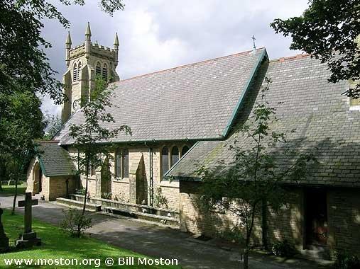
Holy Trinity, Gee Cross, Church of England
hide
Hide
Hide
Holy Trinity,
Higham Lane,
Gee Cross
Hide
It was founded in 1874.
Higham Lane.
Church History
Opened 1874 as a chapel to Hyde: St. George. In 1880 it became the district church for parts of the townships of Hyde and Werneth (previously served by Werneth: St. Paul, Hyde: St. George, and Hyde: St. Thomas). The boundaries of "The Consolidated Chapelry of the Holy Trinity, Gee Cross" were described in the London Gazette on 27 February 1880:
"All those several contiguous portions of the new parish of Saint Paul, Werneth, of the new parish of Saint George, Hyde, and of the new parish of Saint Thomas, Hyde, all in the county of Chester and in the diocese of Chester, which are comprised within and are bounded by an imaginary line commencing at the point in the middle of the River Tame a little to the north of the buildings called or known as Gibraltar Mill where the boundary dividing the new parish of Saint Mary the Virgin, Haughton, in the county of Lancaster and in the diocese of Manchester from the new parish of Saint Paul, Werneth, aforesaid joins the boundary dividing the last-named new parish from the new parish of Saint George, Hyde aforesaid and extending thence eastward along the last-mentioned boundary for a distance of twenty-eight and a half chains or thereabouts (thereby crossing the Peak Forest Canal and crossing also the line of the Sheffield and Midland Joint Railway) to a point in the middle of the line of the Godley and Woodley Branch of the Great Northern Manchester Sheffield and Lincolnshire Joint Stock Railway and extending thence north-eastward along the last-named branch line of railway for a distance of forty-two and a half chains or thereabouts to a point at or near to the mile-post on the same branch line of railway indicating a distance of one mile from Godley Junction such point being opposite to the middle of the southern end of Back Meadow-street and extending that is from the last-described point northward and in a straight line for a distance of one chain or thereabouts to a point in the middle of the southern end of Back Meadow-street aforesaid and continuing thence still northward along the middle of the said street for a distance of three chains or thereabouts to its junction with Meadow-street and extending thence eastward along the middle of the last-named street for a distance of two chains or thereabouts to its junction with the Stockport-road and extending thence northward along the middle of the last-named road for a distance of three chains or thereabouts to its junction with Hyde-lane and with Smithy-lane and extending thence north-eastward along the middle of the last-named lane for a distance of two and three-quarter chains or thereabouts to its junction with Back-lane and extending thence eastward and in a direct line diagonally across the last-named- lane (thereby crossing the boundary which divides the said new parish of Saint George, Hyde, from the new parish of Saint Thomas Hyde, aforesaid) to the junction of the said Back-lane with Bayley-street and extending thence eastward along the middle of the last-named street for a distance of one chain or thereabouts to its present eastern end and continuing thence still in precisely the same direction and in a straight line for a distance of six and a half chains or thereabouts to the middle of the north-western end of Ridings Bridge over the line of the Godley and Woodley Branch, of the Great Northern Manchester Sheffield and Lincolnshire Joint Stock Railway aforesaid and extending thence south-eastward along the middle of the last-mentioned bridge to a point immediately over the middle of the said branch line of railway and extending thence north-eastward along the middle of the same branch line of railway for a distance of sixteen and a half chains or thereabouts to a point at Werneth Brook upon the boundary which divides the said new parish of Saint Thomas, Hyde, from the new parish of Godley-cum Newton Green in the said county of Chester and in the diocese of Chester aforesaid and extending thence first southward then generally southeastward and then again southward along the last-mentioned boundary for a distance of sixty chains or thereabouts to its junction on the southern side of the turnpike-road known as Mottram Old-road and leading from Mottram-in-Longdedale to Stockport with the boundary which divides the said new parish of Godlcy-cum-Newton Green from the new parish of Saint Paul Werneth aforesaid and extending thence first south-eastward and then eastward along the last-described boundary for a distance of eighteen and a half chains or thereabouts to its junction at Godley Brook with the boundary which divides the said new parish of Saint Paul, Werneth, from the parish of Mottram-in-Longdendale in the last-named county and diocese and extending thence first generally southward then south-westward and then again southward along the last-mentioned boundary for a distance of thirty-eight chains or thereabouts to a point in the middle of the road leading from Mottram-in-Longdendale over the hill called or known as Werneth Low to Romiley and extending thence south-westward along the middle of the last-described road for a distance of one mile and thirty-eight chains or thereabouts (thereby passing the houses called or known respectively as Lofty- top, Cheetham Smithy and Lowtop) to a point at the junction of the same road wi th the road leading to new houses upon the boundary dividing the said new parish of Saint Paul, Werneth, from the district chapelry of Chadkirk in the said last-named county and diocese and extending thence first westward then northward and then again, westward along the last-mentioned boundary for a distance of twenty-four chains or thereabouts to its junction with the boundary dividing the said new parish of Saint Paul, Werneth, from the new parish of Saint Mark Bredbury in the said last-mentioned county and diocese and extending thence first generally northward and then generally north-westward along the last-mentioned boundary for a distance of one mile and fifteen chains or thereabouts (thereby crossing the hereinbefore-mentioned line of the Sheffield and Midland Joint Railway and also crossing the Peak Forest Canal aforesaid) to the point in the middle of the River Tame aforesaid where the said last-mentioned boundary joins the boundary dividing the said new parish of Saint Paul, Werneth, from the new parish of Saint Mary the Virgin Haughton aforesaid and extending thence-first northward and then north-eastward along the last-mentioned boundary for a distance of twenty-nine chains or thereabouts (thereby also following in the middle of the River Tame aforesaid the boundary dividing the said county of Chester from the said county of Lancaster) to the first-described point a little to the north of .the buildings called or known as Gibraltar Mill aforesaid where .the said last-mentioned new parish boundary joins the.boundary dividing the said new parish of Saint Paul Werneth, from the new parish of Saint George, Hyde as aforesaid at which point the said imaginary line commenced."
Church Records
C = Christenings (Baptisms) ; M = Marriages ; B = Burials ; BTs = Bishop's Transcripts
| Original Registers | C from 1874; M from 1875 ; B from 1874 — Church |
| Bishop's Transcripts | 1891-1902 (microfilmed) — Cheshire Archives |
| Copies and Indexes | M 1875-2005 — Cheshire BMD (TA:CE24) |
| Monumental Inscriptions | 1972 (partial survey) — Cheshire Archives |
- OpenStreetMap
- Google Maps
- StreetMap (Current Ordnance Survey maps)
- Bing (was Multimap)
- Old Maps Online
- National Library of Scotland (Old Ordnance Survey maps)
- Vision of Britain (Click "Historical units & statistics" for administrative areas.)
- English Jurisdictions in 1851 (Unfortunately the LDS have removed the facility to enable us to specify a starting location, you will need to search yourself on their map.)
- Magic (Geographic information) (Click + on map if it doesn't show)
- GeoHack (Links to on-line maps and location specific services.)