
Hide
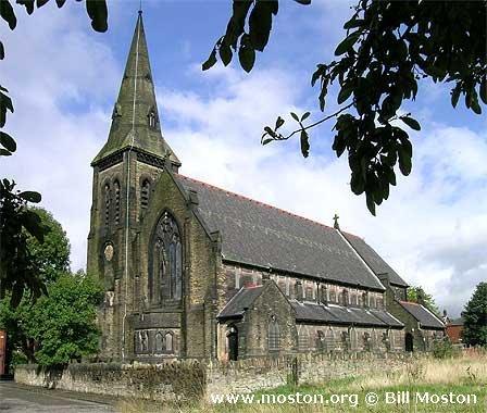
St Stephen, Hyde, Church of England
hide
Hide
Hide
St Stephen,
Bennett Street (was Henry Street), Flowery Field,
Hyde
Hide
It was founded in 1889. It closed in 2011.
Bennett Street, Hyde.
Church History
Founded in 1889 as a chapel to Hyde: St. George. In 1891 it became the district church for parts of the townships of Hyde and Newton (previously served by Newton in Mottram: St. Mary and Hyde: St. George). The boundaries of "The Consolidated Chapelry of Saint Stephen Flowery Field Newton" were described in the London Gazette on 2 October 1891:
"I. All that portion of the new parish (sometime district chapelry) of Saint Mary Newton-in-Mottram (commonly called Saint Mary Newton Moor) in the county of Chester and in the diocese of Chester, which is bounded upon the north partly by the new parish of Saint John the Evangelist Dukinfield and partly by the new parish of Saint Mark Dukinfield, both in the county and diocese aforesaid, upon the west by the new parish of Saint Anne Haughton situate partly in the county of Lancaster and partly in the said county of Chester and wholly in the diocese of Manchester, upon the south partly by the last-named new parish partly by the hereinafter described portion of the new parish (sometime chapelry district) of Saint George Hyde, and partly by the new parish of Godley-cum-Newton Green both in the said county of Chester and in the diocese of Chester aforesaid, and upon the remaining side, that is to say upon the east by an imaginary line, commencing upon the boundary which divides the said new parish of Godley-cum-Newton Green from the new parish of Saint Mary Newton-in-Mottram (commonly called Saint Mary Newton Moor) aforesaid at the centre of the bridge over the line of the Manchester Sheffield and Lincolnshire Railway which bridge connects the road called or known as Commercial Brow with Victoria-street (formerly known as Backlane) and with Ashton-road and extending thence first northward and then north-westward along the middle of the last-named road for a distance of fifty-two and a half chains or thereabouts, to the boundary at Johnson Brook which boundary divides the said new parish of Saint Mary Newton-in-Mottram (commonly called Saint Mary Newton Moor) from the new parish of Saint John the Evangelist Dukinfield aforesaid"
" II. And also all that contiguous portion of the said new parish of Saint George Hyde which is bounded upon the west by the said new parish of Saint Anne Haughton, upon the north by the above-described portion of the said new parish of Saint Mary Newton-in-Mottram (commonly called Saint Mary Newton Moor) upon the east partly by the said above-described portion of the last-named new parish and partly by the new parish of Godley-cum-Newton Green aforesaid, and upon the remaining side, that is to say, upon the south, by an imaginary line, commencing upon the boundary which divides the said new parish of Godley-cum-Newton Green from the new parish of Saint George Hyde aforesaid, at a point in the middle of Godley Brook near Carrfield Cotton Mill and extending thence south-westward along the middle of the said brook for a distance of seventeen and a half chains or thereabouts thereby passing under certain buildings forming, part of the said mill, to the point on the eastern side of the embankment of the line of the Manchester Sheffield and Midland Railway where such brook enters the culvert under the said embankment and continuing thence in precisely the same direction that is to say south-westward and in a straight line for a further distance of five chains or thereabouts (thereby crossing the last-mentioned line of railway) to the boundary in the middle of the Peak Forest Canal which boundary divides the said new parish of Saint George Hyde from the .new parish of Saint Anne Haughton aforesaid."
Church Records
C = Christenings (Baptisms) ; M = Marriages ; B = Burials ; BTs = Bishop's Transcripts
| Original Registers | C 1891-2009 ; M 1891-2007 — Cheshire Archives (P 30) C from 2009 ; M from 2007 — Church |
| Microfilm Copies | C 1891-1938 ; M 1891-1946 — Cheshire Archives ; Tameside Local Studies |
| Copies and Indexes | M 1891-2007 — Cheshire BMD (TA:CE32) |
- OpenStreetMap
- Google Maps
- StreetMap (Current Ordnance Survey maps)
- Bing (was Multimap)
- Old Maps Online
- National Library of Scotland (Old Ordnance Survey maps)
- Vision of Britain (Click "Historical units & statistics" for administrative areas.)
- English Jurisdictions in 1851 (Unfortunately the LDS have removed the facility to enable us to specify a starting location, you will need to search yourself on their map.)
- Magic (Geographic information) (Click + on map if it doesn't show)
- GeoHack (Links to on-line maps and location specific services.)