
Hide
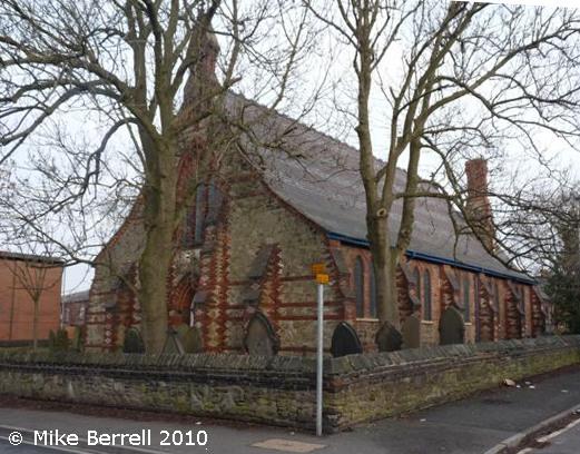
St Thomas the Apostle, Hyde, Church of England
hide
Hide
Hide
St Thomas the Apostle,
Lumn Road,
Hyde
Hide
It was founded in 1846.
Lumm Road.
Church History
Founded in 1846 as a parish church serving part of the township of Hyde (previously served by Hyde: St. George). The boundaries of "The District of Saint Thomas, Hyde" were described in the London Gazette on 8 September 1846:
"All that part of the township of Hyde, in the parish of Stockport, in the county and diocese of Chester, situate on the eastern side of an imaginary line commencing at a point (marked a on the map or plan hereunto annexed) on the boundary of such township where it is crossed by the highway, commonly called Hyde Back-lane, from Gee-cross to Hyde, and thence extending northward along the middle of such, highway and of Back-lane to a point (marked b as aforesaid) opposite to the north eastern end of Wood-street, and thence towards the north west along the middle of such street, and of Vernon-street to a point (marked, c as aforesaid) at the extreme southern end of Norfolk-street, and thence northward along the middle of such street as far as the middle of the turnpike road from Hyde to Ashton-under-Lyne, and thence westward along the middle of such turnpike road to a.point (marked c as aforesaid) opposite to the middle of Clarendon-street, and thence northward along the middle of such last-mentioned street, and continuing in a straight direction to the boundary of the said township of Hyde"
The district was affected by the following boundary changes:
- 1880 February 27 — reduced when part of the township of Hyde was transferred to the new district of Gee Cross: Holy Trinity.
Church Records
C = Christenings (Baptisms) ; M = Marriages ; B = Burials ; BTs = Bishop's Transcripts
| Original Registers | C 1847-1924 ; M 1869-1919 ; B 1868-1900 — Cheshire Archives (P 154) C from 1924 ; M from 1919 ; B from 1900 — Church |
| Microfilm Copies | C 1847-1924 ; M 1869-1919 ; B 1868-1900 — Cheshire Archives ; Manchester Archives & Local Studies ; Tameside Local Studies ; Family History Society of Cheshire |
| Bishop's Transcripts | 1851, 1868-1871 (microfilmed) — Cheshire Archives |
| Copies and Indexes | M 1869-1941 — Cheshire BMD (TA:CE29) B 1868-1980 — National Burial Index B 1868-1980 — published by North Cheshire Family History Society |
- OpenStreetMap
- Google Maps
- StreetMap (Current Ordnance Survey maps)
- Bing (was Multimap)
- Old Maps Online
- National Library of Scotland (Old Ordnance Survey maps)
- Vision of Britain (Click "Historical units & statistics" for administrative areas.)
- English Jurisdictions in 1851 (Unfortunately the LDS have removed the facility to enable us to specify a starting location, you will need to search yourself on their map.)
- Magic (Geographic information) (Click + on map if it doesn't show)
- GeoHack (Links to on-line maps and location specific services.)