
Hide
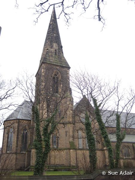
St James, New Brighton, Church of England
hide
Hide
Hide
St James,
Albion Street/Victoria Road,
New Brighton
Hide
It was founded in 1856.
Victoria Road
Church History
Built in 1856 as a chapel to Wallasey: St. Hilary. In 1861 it became a district church for parts of the townships of Liscard and Wallasey (previously served by Wallasey: St. Hilary). The boundaries of "The District Chapelry of Saint James, New Brighton" were described in the London Gazette on 15 October 1861:
"All that part of the parish of Wallasey, in the county of Chester, and diocese of Chester, which is situate to the east of an imaginary line commencing at a point in the middle of Marsden-lane, opposite to a boundary stone inscribed 'N. B. St. J. D. C., 1861, No. 1,' and placed on the eastern side of such lane, opposite to the western end of the fence which divides the close numbered 237 on the tithe commutation map of the said parish of Wallasey, and on the map hereunto annexed, from the close numbered 238 on the same maps, and extending thence, first north-westward and then north-eastward along the middle of the said lane, as far as a point opposite to the middle of the southern end of Mount-road, and extending thence in a direction, generally northward, to and along the middle of such road to its northern extremity, and extending thence westward to the fence dividing the close numbered 484 on the said maps, from the premises numbered 486 and the closed numbered 485, on the same maps, and extending thence northward along the middle of such fence to its extremity, and continuing thence in the last-mentioned direction, and in a straight line to the northern boundary of the said parish of Wallasey. And which said part of the same parish is situate to the north of another imaginary line commencing at the first-mentioned point in the middle of Marsden-lane, opposite to the boundary stone aforesaid, and extending thence eastward to such boundary stone, and continuing thence in the same direction, and in a straight line across the close numbered 237 as aforesaid, to the middle of the western end of the fence which divides the close numbered 236 on the said maps from the closes numbered respectively 238A, and 277 on the same maps, and extending thence south-eastward along the middle of the last-mentioned fence, and of the fence which divides the close numbered 279 on the said maps from the close numbered 276 on the same maps, to the middle of the western end of a certain occupation road leading from the close numbered 279 as aforesaid, to Rake-lane, and extending thence first in the last-mentioned direction, along the middle of such occupation road, and then north-eastward along the middle of the Rake-lane, as far as a point in the same lane opposite to the middle of the western end of Zigzag-lane, and extending thence in the lastmentioned direction to and along the middle of the last-named lane, and along the middle of the footpath leading therefrom to the River Mersey, as far as a point opposite to a boundary stone placed on the southern side of the same footpath, and inscribed 'N. B. St. J. D. C., 1861, No. 2,' and extending thence in a straight line eastward, to the eastern boundary of the said parish of Wallasey. And also all that part of the same parish of Wallasey, which is comprised within the island known as 'Rock Fort'."'
The district was affected by the following boundary changes:
- 1907 July 16 — enlarged when the following area was transferred from Wallasey: St. Hilary: "All that portion of the parish of Wallasey, in the said county and diocese, which is bounded upon the north by the sea, upon the north-east and upon the south-east by the said new parish of Saint James, New Brighton, and upon the remaining sides, that is to say, upon the southwest and upon the west, by an imaginary line commencing upon the boundary which divides the said new parish of Saint James, New Brighton, from the said parish of Wallasey at the junction of Mount Pleasant-road with the road called Hose Side and extending thence northwestward along the middle of Hose Side for a distance of thirteen chains or thereabouts to its junction with Grove-road, and extending thence westward along the middle of Grove-road for a distance of fifteen chains aud a half or thereabouts to its junction with Sea-road and extending thence north-westward along the middle of Sea-road for a distance of thirty chains or thereabouts to its present northern end and continuing thence north-westward in precisely the same direction and in a straight line to the sea".
- 1907 July 16 — reduced when the following area was transferred to Wallasey: St. Hilary: "All that portion of the said new parish of Saint James, New Brighton, which is bounded upon the greater part of the north-west and upon the south-west by the said parish of Wallasey, and upon the remaining sides, that is to say, upon the south-east, upon the north-east, and upon the remaining part of the north-west, by an imaginary line commencing upon the boundary which divides the said parish of Wallasey from the said new parish of Saint James, New Brighton, at the junction of Sea view-road with Earlston-road, and extending thence north-eastward along the middle of Earlston-road for a distance of twentythree chains aud a quarter or thereabouts to its junction with the footpath leading from Earlstonroad to Mount Pleasant-road, and extending thence north-westward along the middle of the said footpath for a distance of eight chains or thereabouts to its junction with Mount Pleasant-road, and extending thence south-westward along the middle of Mount Pleasant-road for a distance of two chains and a quarter or thereabouts to its junction with Mount-road upon the boundary which divides the said new parish of Saint James, New Brighton, from the said parish of Wallasey".
- 1907 July 16 — reduced when the following area was transferred to Liscard: St. Mary: "All that portion of the said new parish of Saint James, New Brighton, which is bounded upon the south by the said new parish of Saint Mary, Liscard, and upon the remaining sides, that is to say, upon the north-west and upon the north-east by an imaginary line commencing at the point in the middle of Seaview-road, opposite to the south-western end of the wall forming the southern boundary of Wallasey Cemetery where the boundaries of the said new parish of Saint Mary, Liscard, the said parish of Wallasey and the said new parish of Saint James, New Brighton, all meet, and extending thence first north-eastward to the said boundary wall and then first north-eastward, then south-eastward, and. then south-westward along, the said boundary wall for a distance of eleven, chains or thereabouts to the boundary which divides, the said new parish of Saint James, New Brighton, from the said new parish of Saint Mary, Liscard."
- 1909 May 18 — reduced when parts of the townships of Liscard and Wallasey were transferred to New Brighton: Emmanuel.
- 1929 March 26 — reduced when an area was transferred to New Brighton: All Saints.
Church Records
C = Christenings (Baptisms) ; M = Marriages ; B = Burials ; BTs = Bishop's Transcripts
| Original Registers | C 1856-1956 ; M 1860-1966 — Cheshire Archives (P 140) C from 1956 ; M from 1966 — Church |
| Microfilm Copies | C 1856-1920 ; M 1860-1934 — Cheshire Archives C 1856-1888 — Family History Society of Cheshire ; Birkenhead Central Library |
| Copies and Indexes | M 1860-1946 — Cheshire BMD (WR:C8) |
- OpenStreetMap
- Google Maps
- StreetMap (Current Ordnance Survey maps)
- Bing (was Multimap)
- Old Maps Online
- National Library of Scotland (Old Ordnance Survey maps)
- Vision of Britain (Click "Historical units & statistics" for administrative areas.)
- English Jurisdictions in 1851 (Unfortunately the LDS have removed the facility to enable us to specify a starting location, you will need to search yourself on their map.)
- Magic (Geographic information) (Click + on map if it doesn't show)
- GeoHack (Links to on-line maps and location specific services.)