
Hide
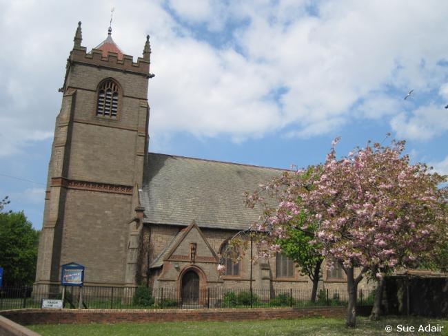
St Mary, Liscard, Church of England
hide
Hide
Hide
St Mary,
Manor Lane/Withens Lane,
Liscard
Hide
It was founded in 1877.
Manor Lane/Withens Lane
Church History
Built in 1877 to be the district church for parts of the townships of Liscard and Wallasey (previously served by Wallasey: St. Hilary). The boundaries of "The District Chapelry of Saint Mary, Liscard" were described in the London Gazette on 5 July 1878:
"All that part of the parish of Wallasey in the county of Chester and in the diocese of Chester wherein the present incumbent of such parish now possesses the exclusive cure of souls which is bounded on the north-east by the eastern boundary of the said parish of Wallasey in the middle of the River Mersey on the north-west by the new parish of Saint James New Brighton within the original limits of the parish of Wallasey aforesaid and upon ail other sides that is to say on the west and on the south-east by an imaginary line commencing upon the boundary which divides the said new parish of Saint James New Brighton from the parish of Wallasey aforesaid at a point in the middle of Marsden-lane opposite to a boundary stone inscribed 'N. B. St. J. D. C. 1861 No. 1 ' and placed on the eastern side of such lane and extending thence south-eastward along the middle of the same lane for a distance of five and a half chains or thereabouts to the boundary which divides the township of Wallasey in the said parish of Wallasey from the township of Liscard in the same parish and extending thence first generally southward and then south-eastward along the said township boundary for a distance of forty-three chains or thereabouts to the point on the south-eastern side of Mill-lane where the same township boundary joins the boundary dividing the said township of Liscard from the township of Poolton-cum-Seacombe in the parish of Wallasey aforesaid and extending thence first north-eastward and then south-eastward along the last-mentioned township boundary for a distance of sixteen chains or thereabouts to a point in the middle of the footpath leading from Poolton into Liscard-road and extending thence north-eastward along the middle of die said footpath for a distance of ten and a half chains or thereabouts to its junction with Liscard-road aforesaid and extending thence eastward along the middle of tho last-named road for a distance of two and a half chains or thereabouts to its junction with Martin's-lane and extending thence first north-eastward and then northward along the middle of the last-named lane for a distance of twenty-two and a half chains or thereabouts to its junction with Green-lane and extending thence north-eastward along the middle of the last-named lane for a distance of five chains or thereabouts to its junction with Rice-lane and extending thence south-eastward along the middle of the last-named lane for a distance of six and a half chains or thereabouts to its junction with Trafalgar-road and extending thence north-eastward along the middle of the last-named road for a distance of twenty-four and a half chains or thereabouts to its north-eastern end on the shore of the River Mersey aforesaid and continuing thence still north-eastward and in a direct liine to the eastern boundary of the pnid parish of Wallasey in the middle of the River Mersey as aforesaid."
The district was affected by the following boundary changes:
- 1907 July 16 — enlarged when the following area was transferred from New Brighton: St. James: "All that portion of the said new parish of Saint James, New Brighton, which is bounded upon the south by the said new parish of Saint Mary, Liscard, and upon the remaining sides, that is to say, upon the north-west and upon the north-east by an imaginary line commencing at the point in the middle of Seaview-road, opposite to the south-western end of the wall forming the southern boundary of Wallasey Cemetery where the boundaries of the said new parish of Saint Mary, Liscard, the said parish of Wallasey and the said new parish of Saint James, New Brighton, all meet, and extending thence first north-eastward to the said boundary wall and then first north-eastward, then south-eastward, and. then south-westward along, the said boundary wall for a distance of eleven, chains or thereabouts to the boundary which divides, the said new parish of Saint James, New Brighton, from the said new parish of Saint Mary, Liscard."
- 1925 December 29 — reduced when an area was transfered to Liscard: St. Thomas.
On 8 June 1971 the district was amalgamated with that of Liscard: St. Columba, to form the combined district of "Liscard: St. Mary with St. Columba".
Church Records
C = Christenings (Baptisms) ; M = Marriages ; B = Burials ; BTs = Bishop's Transcripts
| Original Registers | C 1877-1925 ; M 1878-1930 — Cheshire Archives (P 226) C from 1925 ; M from 1930 — Church |
| Microfilm Copies | C 1877-1925 ; M 1878-1930 — Cheshire Archives |
| Copies and Indexes | M 1878-1952 — Cheshire BMD (WR:C3) |
| Notes | B — none |
- OpenStreetMap
- Google Maps
- StreetMap (Current Ordnance Survey maps)
- Bing (was Multimap)
- Old Maps Online
- National Library of Scotland (Old Ordnance Survey maps)
- Vision of Britain (Click "Historical units & statistics" for administrative areas.)
- English Jurisdictions in 1851 (Unfortunately the LDS have removed the facility to enable us to specify a starting location, you will need to search yourself on their map.)
- Magic (Geographic information) (Click + on map if it doesn't show)
- GeoHack (Links to on-line maps and location specific services.)