
Hide
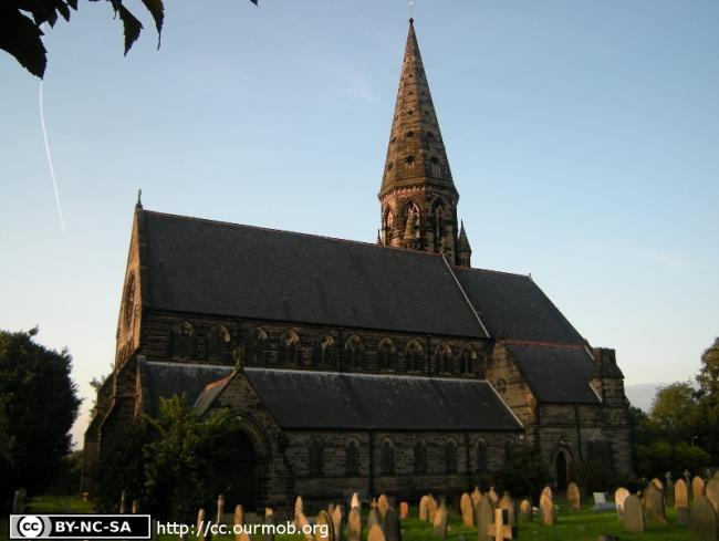
St Peter, Oughtrington, Church of England
hide
Hide
Hide
St Peter,
Oughtrington Lane,
Oughtrington
Hide
It was founded in 1872.
Oughtrington Lane, Lymm.
Church History
Built in 1872 as a chapel to Lymm: St. Mary the Virgin. On 23 December 1881 it became the district church for part of the township of Lymm (previously served by Lymm: St. Mary the Virgin). The boundaries of "The District Chapelry of Saint Peter, Oughtrington" were described in the London Gazette on 30 January 1874:
""All that portion of the ancient parish of Lymm, which is situate generally to the east of an imaginary line commencing upon the boundary which divides the county of Lancaster from the county of Chester, at a point in the middle of the River Mersey opposite to the point where it is joined by the Sow Brook; and extending thence first south-eastward, then southward, and then south-westward to and along the middle of the said brook to the point where it is crossed by the line of the Warrington and Stockport Branch of the London and North Western Railway; and extending thence north-eastward for a distance of twenty-three chains, or thereabouts along the middle of the said branch line of railway to the point at which it is carried over a certain occupation road. leading from the enclosure numbered 448, on the tithe commutation map of the said parish of Lymm, and upon the map hereunto annexed, into Reddish-lane ; and extending thence southward to and along the middle of the said occupation road to its junction with Reddish-lane iforesaid, at or near to which point of junction a boundary stone inscribed on its western side 'L. P., 1873, No. 1,' and on its eastern side 'O. P., 1873, No. 1,' has been placed on the southern side of the same lane; and extending thence southward, and in a direct line, for a disance of twenty-eight chains, or there abouts thereby crossing the Duke of Bridgewater's Canal) to a boundary stone inscribed on its western side 'L. P., 1873, No. 2,' and on. its eastern ide 'O. P., 1873, No. 2,' and placed on the northern side of the road, called or known as Pepper-street, opposite to the middle of the northern end of Long Butt-lane; and continuing hence for a 'distance of fourteen chains, or thereabouts, first southward and then south-eastward to and along the middle of the last-named lane to a point opposite to a flight of steps forming the approach to a public footpath which leads along he eastern side of the grounds attached to Lymm Jail, into the turnpike-road leading from Warrington to Altrincham ; and extending.thence first southward, then south-eastward, and then again southward to and along the middle of the said public footpath to its junction with the turnpike road leading, from Warrington to Altrincham as aforesaid ; and extending thence north-westward, fr a distance of thirty-four yards, or thereabouts, along the middle of .the said turnpike-road, to its junction with a certain occupation road leading to the close numbered 1332 upon the said maps; and extending thence southward for a distance of one hundred yards, or thereabouts, along the middle of the last-described occupation road to its southern end; and extending thence south-westward, and in a direct line, for a distance of thirteen and a half chains, or thereabouts, to a boundary stone inscribed on its western side 'L. P., 1873, No. 3,' and on its eastern side 'O. P., 1873, No. 3,' and placed at the western end of the fence which divides the close numbered 1343 upon the said maps, from the close numbered 1344 upon the same maps, on the eastern side of Crouchley-lane ; and extending thence for a distance of fifty-two and a-half chains., or thereabouts, alternately southward and south-eastward to and along the middle of the last-named lane to its junction with Mag-lane ; and extending thence southwestward for a distance of nine chains, or thereabouts, along the middle of the last-named lane to the boundary which divides the said parish of Lymm from the chapelry of High Leigh, in the parish of Rostherne, in the county and diocese of Chester.'
Church Records
C = Christenings (Baptisms) ; M = Marriages ; B = Burials ; BTs = Bishop's Transcripts
| Original Registers | C 1872-1966 ; M 1882-1938 ; B 1872-1910 — Cheshire Archives (P 237) C from 1966 ; M from 1938 ; B from 1910 — Church |
| Microfilm Copies | C 1872-1966 ; M 1882-1938 ; B 1872-1910 — Cheshire Archives |
| Bishop's Transcripts | 1872-76, 1892-99, 1901 (microfilmed) — Cheshire Archives |
| Copies and Indexes | M 1882-1933 — Cheshire BMD (WA:C16) |
- OpenStreetMap
- Google Maps
- StreetMap (Current Ordnance Survey maps)
- Bing (was Multimap)
- Old Maps Online
- National Library of Scotland (Old Ordnance Survey maps)
- Vision of Britain (Click "Historical units & statistics" for administrative areas.)
- English Jurisdictions in 1851 (Unfortunately the LDS have removed the facility to enable us to specify a starting location, you will need to search yourself on their map.)
- Magic (Geographic information) (Click + on map if it doesn't show)
- GeoHack (Links to on-line maps and location specific services.)