
Hide
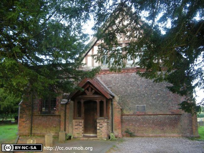
All Saints and St Mary, Ringway, Church of England
hide
Hide
Hide
All Saints and St Mary,
Wilmslow Old Road/Sunbank Lane,
Ringway
Hide
It was founded in 1515. It closed in 1970.
Church History
An ancient chapel to Bowdon: St. Mary, which became the district church for parts of the townships of Hale and Baguley in 1863. The boundaries of "The District Chapelry of Ringway" were described in the London Gazette on 15 September 1863:
"All that part of the parish of Bowdon, in the county of Chester, and in the diocese of Chester, wherein the present incumbent of such parish now possesses the exclusive cure of souls which is situate to the north-east of an imaginary line commencing upon the boundary which divides the said parish from the particular district of Christ Church, Timperley (heretofore part of the said parish of Bowdon), at the point of junction (near Warburtbn's Farm) of Long-lane with Shaw-lane, which said point is opposite to the middle of the north-western end of the road leading to Ringway, and extending thence, south-eastward, to and along the middle of the last described road as far as a point (near Hale Mount) opposite to the middle of the.north-eastern end of the road leading from such last described road through Hale Barns, and by Spring Vale, and through Warburton Green, and past Hale Bank towards Castle Mill and Ashley ; and extending thence, first, south-westward, to and along the middle of the last described road, and then generally southeastward, along the middle of the same road as far as a point opposite to a boundary stone inscribed "R. D. C., 1863," and placed on the northern side of the said road, at a distance of about seventy yards, west of Hale Bank aforesaid, and also opposite to the middle of the northern end of the public footpath leading from the said Hale Bank, across the river Bollin to Ashley; and extending thence, first, south-westward, to and along the middle of the said footpath, as far as the northern bank of the said river ; and continuing thence, first south-eastward* and then again south-westward, still along the middle of the same footpath, as far as the boundary dividing the township of Hale, in the said parish of Bowdon, from the township of Ashley in the same parish, at a point in the centre of the bridge which carries the said footpath over the River Bollin aforesaid; and extending thence, in a direction mainly south-eastward along the said township boundary to its junction with the boundary which divides the said parish of Bowdon from the parish of Mobberley, in the county and diocese aforesaid."
Closed in 1967, and succeeded as the district church by Hale Barns: All Saints.
Church Records
C = Christenings (Baptisms) ; M = Marriages ; B = Burials ; BTs = Bishop's Transcripts
| Original Registers | C 1751-1959 ; M 1864-1967 ; B 1826-1992 — Cheshire Archives (P 236) |
| Microfilm Copies | C 1751-1959 ; M 1864-1967 ; B 1826-1997 — Cheshire Archives C 1783-1905 ; M 1864-1967 ; B 1826-1997 — Family History Society of Cheshire |
| Bishop's Transcripts | 1786-98, 1800-16, 1818-92 (microfilmed) — Cheshire Archives ; Family History Society of Cheshire |
| Copies and Indexes | M 1864-1880 — Cheshire BMD (TR:CE33) |
| Monumental Inscriptions | Published by the Family History Society of Cheshire, 1986 |
- OpenStreetMap
- Google Maps
- StreetMap (Current Ordnance Survey maps)
- Bing (was Multimap)
- Old Maps Online
- National Library of Scotland (Old Ordnance Survey maps)
- Vision of Britain (Click "Historical units & statistics" for administrative areas.)
- English Jurisdictions in 1851 (Unfortunately the LDS have removed the facility to enable us to specify a starting location, you will need to search yourself on their map.)
- Magic (Geographic information) (Click + on map if it doesn't show)
- GeoHack (Links to on-line maps and location specific services.)