
Hide
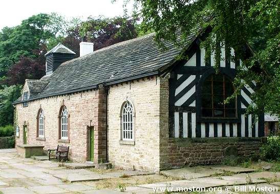
St Chad, Chadkirk, Church of England
hide
Hide
Hide
St Chad,
Vale Road,
Chadkirk
Hide
It was founded in 1748.
Church Lane, Romiley.
Church History
Founded in 1745 as a chapel to Stockport: St. Mary the Virgin. A new church was opened in 1876, which became the district church for part of the township of Romiley (previously served by Stockport: St. Mary the Virgin), but the old chapel continued to be used as a place of worship until 1971. The boundaries of "The District Chapelry of Chadkirk" were described in the London Gazette on 27 October 1876:
"All that part of the parish of Stockport in the county of Chester and in the diocese of Chester which is comprised within and is co-extensive with the limits of that portion of the chapelry of Chadkirk (or in other words of the township of Romiley) which is bounded on the east partly by the county of Derby, on the south by the new parish of Saint Martin Low MarpIe in the said county of Chester and in the diocese aforesaid, on the west by the new parish of Saint Mark Bredbury in the last-named county and diocese, on the north partly by the last-named new parish arid partly by the new parish of Saint Paul Werneth in the same county and diocese, and on the remaining part of the east by an imaginary line commencing at the point where the boundary which divides the said new parish of Saint Paul Werneth from the township of Romiley aforesaid, crosses the road called or known as Cowlisher Brow and which leads from Gee Cross to Compstall and extending thence for a distance of nearly thirty-one chains first south-eastward then southward and then again
south-eastward along the middle of the said road to a point opposite to a boundary-stone inscribed 'C. D. C. 1876 No. 1' and placed on the south-western side of the same road at the north-eastern end of the wall or fence which divides the close numbered 380 upon the 1/2500 scale ordnance survey map of the said parish of Stockpbrt and upon the map hereunto annexed from the close numbered 383 upon the same maps and extending thence first south-westward to the said boundary-stone and then in a direction generally south-eastward along the said wall or fence to its junction with the wall or fence which divides the enclosure called or known as Redbrow Wood and numbered 394 upon the said maps from the enclosure numbered 383 as aforesaid, from the enclosure numbered 391 upon the said maps and forming the gardens and grounds attached to Greenhill Hall, and from the enclosures numbered respectively 392 and 390 upon the same maps, and extending thence first south-eastward then south-westward and then southward along the last described wall or fence to a boundary-stone inscribed 'C. D. C. 1876 No. 2' and placed at the southern end of the same wall or fence on the northern side of the footpath leading from Compstall Bridge along the. northern bank of the River Etherow towards the house called or known as Water Meetings and extending thence that is from the last-mentioned boundary-stone southward and in a direct line across the said footpath to a point in the middle of the said river and extending thence eastward for a distance of two chains or thereabouts along the middle of the same river to the boundary which divides the said township of Romiley from the county of Derby aforesaid."
Church Records
C = Christenings (Baptisms) ; M = Marriages ; B = Burials ; BTs = Bishop's Transcripts
| Original Registers | C 1748-1971 ; M 1748-1754, 1868-1957 ; B 1755-1950 — Cheshire Archives (P 90) C from 1971 ; M from 1957 ; B from 1992 — Church |
| Microfilm Copies | C 1748-1971 ; M 1748-1754, 1868-1957 ; B 1755-1950 — Cheshire Archives C 1748-1889 ; M 1748-1754 ; B 1755-1868 — Manchester Archives & Local Studies ; Stockport Heritage Library |
| Bishop's Transcripts | 1790-1817, 1867-1913 (microfilmed) — Cheshire Archives |
| Copies and Indexes | M 1868-1992 — Cheshire BMD (ST:ST76) B 1755-1901 — National Burial Index B 1755-1901 — published by North Cheshire Family History Society |
| Monumental Inscriptions | Transcript by Stockport Museum Education Service, 1982 — held by Cheshire Archives ; North Cheshire Family History Society |
| Notes | M 1754-1868 — see Stockport: St. Mary the Virgin |
- OpenStreetMap
- Google Maps
- StreetMap (Current Ordnance Survey maps)
- Bing (was Multimap)
- Old Maps Online
- National Library of Scotland (Old Ordnance Survey maps)
- Vision of Britain (Click "Historical units & statistics" for administrative areas.)
- English Jurisdictions in 1851 (Unfortunately the LDS have removed the facility to enable us to specify a starting location, you will need to search yourself on their map.)
- Magic (Geographic information) (Click + on map if it doesn't show)
- GeoHack (Links to on-line maps and location specific services.)