
Hide
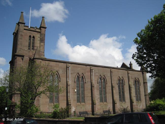
Holy Trinity, Runcorn, Church of England
hide
Hide
Hide
Holy Trinity,
Trinity Street,
Runcorn
Hide
It was founded in 1660.
Trinity Street
Church History
Built in 1838 as a chapel to Runcorn: All Saints. In 1840 it became a district church for part of the township of Runcorn
The district was affected by the following boundary changes:
- 1960 May 20 — reduced when two areas were transferred to Halton: St. Mary the Virgin.
- 1960 May 20 — enlarged when the following area was transferred from Runcorn: St. Michael & All Angels: "All that part of the parish of Saint Michael and All Angels, Runcorn, which is bounded on the east by the parish of Holy Trinity, Runcorn, on the south by imaginary line which is described in paragraph 2 (a) of this schedule, and on the remaining side by an imaginary line commencing at a point in the middle of Heath Road opposite the middle of the western end of Boston Avenue, and proceeding thence northeastwards along the middle of Heath Road to the boundary which divides the parish of Saint Michael and All Angels, Runcorn, from the parish of Holy Trinity, Runcorn".
- 1960 May 20 — enlarged when the following area was transferred from Halton: St. Mary the Virgin: "All that part of the parish of Halton which is bounded on the north by the parish of Holy Trinity, Runcorn, and on the remaining sides by an imaginary line commencing at a point on the boundary which divides the parish of Holy Trinity, Runcorn, from the parish of Halton at the northwestern corner of close numbered 9 (on the map) and proceeding thence southwards along the western boundary of the last mentioned close to ithe point where it meets the northern boundary olf dose numbered 10, thence first westwards then northwestwards along the last mentioned boundary to the boundary which divides the parish of Halton from the parish of Holy Trinity. Runcorn".
In 1973 the district was amalgamated with Halton: St. Mary the Virgin and Grange: St. Andrew to create the combined district of "East Runcorn with Halton".
Church Records
C = Christenings (Baptisms) ; M = Marriages ; B = Burials ; BTs = Bishop's Transcripts
| Original Registers | C 1838-1945 ; M 1861-1959 — Cheshire Archives (P 134) C from 1945 ; M from 1959 — Church |
| Microfilm Copies | C 1838-1945 ; M 1861-1959 — Cheshire Archives ; Halton Lea Library |
| Bishop's Transcripts | 1838-48, 1851, 1854-68 (incomplete) — Cheshire Archives ; Family History Society of Cheshire |
| Copies and Indexes | M 1861-1950 — Cheshire BMD (HA:C11) |
It is located at SJ5161383060 (Lat/Lon 53.342212, -2.728219). You can see this on maps provided by:
- OpenStreetMap
- Google Maps
- StreetMap (Current Ordnance Survey maps)
- Bing (was Multimap)
- Old Maps Online
- National Library of Scotland (Old Ordnance Survey maps)
- Vision of Britain (Click "Historical units & statistics" for administrative areas.)
- English Jurisdictions in 1851 (Unfortunately the LDS have removed the facility to enable us to specify a starting location, you will need to search yourself on their map.)
- Magic (Geographic information) (Click + on map if it doesn't show)
- GeoHack (Links to on-line maps and location specific services.)