
Hide
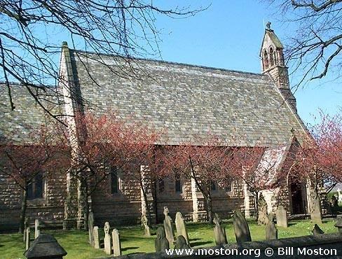
St Peter, Elworth, Church of England
hide
Hide
Hide
St Peter,
London Road/School Lane,
Elworth
Hide
It was founded in 1847.
Church History
Built in 1846 as a chapel to Sandbach: St. Mary, and the following year became the district church for parts of Bradwall, Elton, Moston, Sandbach and Tetton townships (previously served by Sandbach: St. Mary and Warmingham: St. Leonard). The boundaries of "The Consolidated Chapelry of Elworth" were described in the London Gazette on 9 March 1847:
"The boundary of the said consolidated chapelry of Elworth commences at the Grand Trunk Canal, opposite to the road leading from Taylor's cottage, on the road leading from Sandbach to Middlewich, called Booth-lane, and following the eastern bank of the said canal till it reaches Stud-green-bridge; it then crosses the canal, and proceeds along the boundary of the townships of Tetton and Moston, till it meets a lane leading to the Crow .Nestbridge ; it then proceeds along the middle of the said lane till it reaches the canal; it then continues along the western side of the said canal till it reaches the boundary of Moston and Elton townships, which it follows in a south westerly direction till it reaches the road leading from Moston to the Moss-bridge, up the middle of which road it proceeds two hundred and thirty-four yards, and crossing by the garden fence to the south of Barlow's cottage, it reaches a lane, up the middle of which it proceeds easterly, till it reaches a fence leading southerly along the back of Turner's premises ; it then again turns easterly till it reaches the canal, which it follows on its western or towingpath side till it reaches a footpath leading to Red-lane, which it follows, and proceeds along the middle of the said lane, till it reaches the garden fence of Thompson's cottage; proceeds then along the western side of Red-lane, so as to include all houses abutting thereon till it reaches the garden fences at the back of Wilson's cottage, which it follows till it again meets the Red-lane, down to the middle of which it proceeds, till it reaches the road leading to the Rookery-bridge from Elton; it then follows the south side of the said road towards Elton, till it meets a watercourse, and then turning in a south easterly direction, it follows a fence, over which the Manchester and Birmingham Railway passes, till it meets the boundary of the townships of Sandbach and Elton ; along which it then proceeds crossing the canal till it reaches the Sandey-road; up the middle of which it proceeds as far as the turnpike gate in the Sandbach and Middlewich-road; and from thence easterly along the middle of that road, as far as Rithin-lane footpath, which it follows till it reaches Cooksenorlane ; along the middle of which lane it proceeds south easterly till it enters the road leading to Bradwall; it then proceeds northerly up the middle of the said road until it reaches the boundary line which separates the township of Sandbach from the township of Bradwall; along which boundary it then proceeds easterly and south easterly until it reaches the boundary line which separates the said township from the parish of Brereton; it then proceeds along that boundary line, in a northerly and north westerly direction till it meets the parish of Middlewich; and then continues westerly and south westerly along the boundary line, separating the township of Bradwall from the parish of Middlewich until it meets the boundary line separating the said township from the parish of Warmingham; along which boundary it then proceeds southerly until it comes to a point near a road leading from Dale Acre to Taylor's cottage ; along the middle of which road it proceeds south westerly passing Taylor's cottage, to the point where the boundary of the said consolidated chapelry of Elworth commenced".
Church Records
C = Christenings (Baptisms) ; M = Marriages ; B = Burials ; BTs = Bishop's Transcripts
| Original Registers | C 1846-1995 ; M 1847-1997 ; B 1846-1925 — Cheshire Archives (P 207) C from 1995 ; M from 1997 ; B from 1925 — Church |
| Microfilm Copies | C 1846-1915 ; M 1847-1917 ; B 1846-1925 — Cheshire Archives ; Manchester Archives & Local Studies ; Family History Society of Cheshire ; Sandbach Library |
| Copies and Indexes | M 1847-1950 — Cheshire BMD (CC:1039) B 1846-1998 — National Burial Index B 1874-1996 (index by J. A. Watson) — Cheshire Archives |
| Monumental Inscriptions | Transcript by J. A. Watson, 1997 — Cheshire Archives Published by South Cheshire Family History Society, 1999 |
- OpenStreetMap
- Google Maps
- StreetMap (Current Ordnance Survey maps)
- Bing (was Multimap)
- Old Maps Online
- National Library of Scotland (Old Ordnance Survey maps)
- Vision of Britain (Click "Historical units & statistics" for administrative areas.)
- English Jurisdictions in 1851 (Unfortunately the LDS have removed the facility to enable us to specify a starting location, you will need to search yourself on their map.)
- Magic (Geographic information) (Click + on map if it doesn't show)
- GeoHack (Links to on-line maps and location specific services.)