
Hide
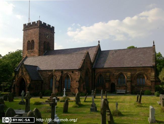
St Bridget, West Kirby, Church of England
hide
Hide
Hide
St Bridget,
Church Road/St Bridgets Lane,
West Kirby
Hide
It was founded in 1561.
Rectory Road
Church History
An ancient parish church, originally serving the townships of Caldy, Frankby, Grange, Great Meols, Hoose, Little Meols, Newton cum Larton and West Kirby, and part of the township of Greasby.
The district was affected by the following boundary changes:
- 1860 July 29 — reduced when the townships of Great Meols, Hoose, and Little Meols, and parts of the townships of Grange and Newton cum Larton were transferred to Hoylake: Holy Trinity.
- 1861 June 28 — reduced when the township of Frankby, and parts of the townships of Grange, Greasby and Newton cum Larton were transferred to the district of Frankby: St. John the Divine.
- 1874 October 23 — reduced when the following part of the township of Caldy was transferred to Thurstaston: St. Bartholomew: "A hamlet or place, consisting of nine cottages, situated on land of twenty-two acres two roods and six perches in extent, known as Up-Caldy".
- 1889 July 9 — enlarged when the following area was transferred from Hoylake: Holy Trinity: "All that part of the said new parish of the Holy Trinity-in-Hoose otherwise known as the Holy Trinity Hoylake which is bounded upon the south-east by the parish of West Kirby aforesaid upon the west by the high water mark of ordinary tides upon the sea shore, or in other words by the western boundary of the said now parish of the Holy Trinity-in-Hoose otherwise known as the Holy Trinity Hoylake and upon the remaining side that is to say upon the north by an imaginary straight line extending due east and west from a boundary stone inscribed 'H. H. T. N. P. 1889 ' and placed on the western s ide of the main road from West Kirby to Hoylake near to the entrance from the said road to the house calied or known as 'Maddock's House', the said imaginary straight line terminating qn the west upon the western boundary of the said new parish of the Holy Trinity-in-Hoose otherwise known as the Holy Trinity Hoylake at the said high water mark of ordinary tides upon the sea shore, and terminating on the east upon the south-eastern boundary of the said new parish which boundary divides the same new parish from the parish of West Kirby aforesaid."
- 1920 August 13 — reduced when an area was transferred to West Kirby: St. Andrew.
The district includes the chapel of Caldy Grange: Church of the Resurrection & All Saints.
Church Records
C = Christenings (Baptisms) ; M = Marriages ; B = Burials ; BTs = Bishop's Transcripts
| Original Registers | C 1561-1964 ; M 1561-1968 ; B 1561-1970 — Cheshire Archives (P 46) C from 1964 ; M from 1968 ; B from 1970 — Church |
| Microfilm Copies | C 1561-1964 ; M 1561-1959 ; B 1561-1886 — Cheshire Archives C 1561-1861 ; M 1561-1905 ; B 1561-1886 — Manchester Archives & Local Studies ; Birkenhead Central Library C 1813-1861 ; M 1754-1905 ; B 1813-1886 — Family History Society of Cheshire |
| Bishop's Transcripts | 1580-81, 1600, 1603-05, 1609-10, 1614-15, 1617-19, 1621-24, 1626-27,1630-31, 1636, 1666, 1669, 1671-72, 1674-76, 1679-82, 1684-85, 1690,1698-1704, 1706-30, 1732, 1734-39, 1741-43, 1746, 1748-1838, 1892-94 (microfilmed) ; 1896-97 — Cheshire Archives(microfilmed: 1580-1894) |
| Copies and Indexes | CMB 1561-1619 (transcript by A. J. Farrington) — Cheshire Archives ; Society of Genealogists' Library CMB 1580-1619 (index) — Cheshire Archives CMB 1561-1871 — Cheshire Parish Register Project CMB 1692-1729 (index by C. Bratt) — Cheshire Archives M 1560-1837 (incomplete) — Bertram Merrell Marriage Index of Cheshire (1750-1836) M 1837-1959 — Cheshire BMD (WR:BK74) B 1561-1871 — National Burial Index |
| Monumental Inscriptions | Published by the Family History Society of Cheshire (edited by C. Bratt), 1973 |
It is located at SJ2182386407 (Lat/Lon 53.368723, -3.176389). You can see this on maps provided by:
- OpenStreetMap
- Google Maps
- StreetMap (Current Ordnance Survey maps)
- Bing (was Multimap)
- Old Maps Online
- National Library of Scotland (Old Ordnance Survey maps)
- Vision of Britain (Click "Historical units & statistics" for administrative areas.)
- English Jurisdictions in 1851 (Unfortunately the LDS have removed the facility to enable us to specify a starting location, you will need to search yourself on their map.)
- Magic (Geographic information) (Click + on map if it doesn't show)
- GeoHack (Links to on-line maps and location specific services.)