
Hide
Cookbury
hide
Hide
hide
- Almanacs◬
- Archives & Libraries◬
- Bibliography◬
- Biography◬
- Business & Commerce Records◬
- Cemeteries
- Census
- Chronology◬
- Church History
- Church Records
- Churches
- Civil Registration◬
- Correctional Institutions◬
- Court Records◬
- Description & Travel
- Directories◬
- Emigration & Immigration◬
- Encyclopaedias & Dictionaries◬
- Folklore◬
- Gazetteers
- Genealogy◬
- Handwriting◬
- Heraldry◬
- Historical Geography◬
Hide
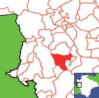
Click on map to view parish boundaries in detail.
Hide
Hide
hide
- History
- Jewish History◬
- Land & Property◬
- Language & Languages◬
- Manors◬
- Maps
- Medical Records◬
- Merchant Marine◬
- Military History◬
- Names, Geographical◬
- Names, Personal◬
- Newspapers◬
- Occupations◬
- Periodicals◬
- Politics & Government◬
- Poor Houses, Poor Law◬
- Population◬
- Probate Records
- Schools◬
- Social Life & Customs◬
- Societies◬
- Taxation◬
- Voting Registers◬
Hide
"COOKBURY, 4 miles N.E. of Holsworthy, has in its parish 301 souls, and 1833 acres of land, mostly belonging to the Earl of Devon, Lord Stanhope, W.H.B. Coham, Esq., and the Misses May; the latter of whom own the manor of Stapledon. The Church (St. John,) is a small fabric, and the benefice is a perpetual curacy, annexed to the rectory of Milton Damerell. The glebe is 24 acres, an the tithe were commuted in 1842 for £118. 2s. 6d. per annum. The Church Meadow (3A.) was given at an early period, on condition that the owners of Dunsland should have the use of two pews. . . ." [From White's Devonshire Directory (1850)]
A parish in Black Torrington Hundred, the Archdeaconry of Totnes and the Diocese of Exeter.
Hide
A few headstone inscriptions from Cookbury Churchyard transcribed by Nicola Aldridge.
Snetzler, M.F. North Devon Surname Index to the Census. Microfiche: M.F. Snetzler. [Covers 1841, 1861, 1871 and 1881 census records for this parish]
Cookbury - from J. Stabb. Some Old Devon Churches (London: 1908-16).
Parish Registers going back to 1746 are held in the Devon Record Office.
Transcripts of the Parish Registers going back to 1746, and of the Bishops' Transcripts going back to 1609, are held in a special collection in the Westcountry Studies Library.
The Devon FHS publishes indexes covering (as of June 2004): Marriages 1754-1837, Burials 1813-1841 - for details see their Devon Parish List.
FHS-Online has Cookbury Baptisms (1746-1944), Burials (1789-2008), Marriages (1750-2009), and St John Cookbury Baptisms (1608-1812) and Marriages (1608-1811) available (subscription).
Kirst Gray offers look-ups of the PRs for the years 1838-1930.
Other churches and chapels (with pre-1840 records):
- Wesleyan Chapel: Registers for c1817-37 - see Holsworthy (PRO RG 4/1210)
Entered into the IGI (as of Jan 1993): Parish Church Christenings 1609-1837 Marriages 1609-1634, 1663-1698, 1721-1737, 1750-1764, 1779-1798, 1811-1837. (These entries are based in part on Bishops' Transcripts.)
An index of baptisms, marriages and burials in the parishes of Abbots Bickington, Ashwater, Black Torrington, Bradford, Bradworthy, Bridgerule, Clawton, Cookbury, Halwill, Hollacombe, Holsworthy, Luffincott, Milton Damerel, Pancrasweek, Pyworthy, Sutcombe, Tetcott, Thornbury, West Putford and Holsworthy Weslyan Burials. With photographs of the churches and extracts from White's Directory (1850), Kelly's Directory of Devonshire (1902) and A Topographical Dictionary of England, Samuel Lewis (1831), CD-ROM, Exeter, Devon FHS (2014). [Abbots Bickington Bapt: 1813-1840 Mar: 1770-1833 Bur: 1813-1837; Ashwater Bapt: 1813-1841 Mar: 1754-1837 Bur: 1813-1837; Black Torrington Bapt: 1813-1839 Mar: 1754-1837 Bur: 1813-1837; Bradford Bapt: 1813-1839 Mar: 1754-1837 Bur: 1705-1837; Bradworthy Bapt: 1813-1838 Mar: 1755-1837 Bur: 1813-1837; Bridgerule Bapt: 1813-1839 Mar: 1755-1837 Bur: 1813-1837; Clawton Bapt: 1813-1839 Mar: 1754-1837 Bur: 1800-1837; Cookbury Bapt: 1813-1839 Mar: 1756-1837 Bur: 1813-1841; Halwill Bapt: 1813-1839 Mar: 1754-1837 Bur: 1813-1843; Hollacombe Bapt: 1813-1898 Mar: 1757-1837 Bur: 1813-1852; Holsworthy Bapt: 1813-1839 Mar: 1754-1860 Bur: 1813-1837; Holsworthy Weslyan Bapt: 1812-1831; Luffincott Bapt: 1813-1839 Mar: 1756-1837 Bur: 1814-1840; Milton Damerel Bapt: 1813-1840 Mar: 1761-1837 Bur: 1813-1837; Pancrasweek Bapt: 1813-1840 Mar: 1756-1837 Bur: 1813-1837; Pyworthy Bapt: 1813-1839 Mar: 1755-1837 Bur: 1813-1838; Sutcombe Bapt: 1813-1840 Mar: 1754-1837 Bur: 1800-1837; Tetcott Bapt: 1813-1839 Mar: 1755-1836 Bur: 1813-1837; Thornbury Bapt: 1813-1839 Mar: 1756-1837 Bur: 1813-1837; West Putford Bapt: 1813-1840 Mar: 1754-1837 Bur: 1813-1838.]
Section on Cookbury from Samuel Lewis: A Topographical Dictionary of England (1831), provided by Mel Lockie.
The transcription of the section for this parish from the National Gazetteer (1868), provided by Colin Hinson.
- Ask for a calculation of the distance from Cookbury to another place.
Williams, H. Fulford. Notes on the Parish of Cookbury, Devon. Typescript (1963) 4 leaves. [Westcountry Studies Library]
View a map of the boundaries of this town/parish.
You can see maps centred on OS grid reference SS406060 (Lat/Lon: 50.831528, -4.264873), Cookbury which are provided by:
- OpenStreetMap
- Google Maps
- StreetMap (Current Ordnance Survey maps)
- Bing (was Multimap)
- Old Maps Online
- National Library of Scotland (Old Ordnance Survey maps)
- Vision of Britain (Click "Historical units & statistics" for administrative areas.)
- English Jurisdictions in 1851 (Unfortunately the LDS have removed the facility to enable us to specify a starting location, you will need to search yourself on their map.)
- Magic (Geographic information) (Click + on map if it doesn't show)
- GeoHack (Links to on-line maps and location specific services.)
- All places within the same township/parish shown on an Openstreetmap map.
- Nearby townships/parishes shown on an Openstreetmap map.
- Nearby places shown on an Openstreetmap map.
Listing of Estate Duty and PCC wills, compiled by Kathryn Barnett.