
Hide
hide
Hide
THE SOCIAL STRUCTURE
OF
THE PARISH OF HARTLAND (NORTH DEVON)
(1558 - 1620)
by Michael J.L. Wickes.
A dissertation prepared in part fulfilment of the requirements for the M.A. in English Local History at the University of Leicester.
Session 1979-80.
[This transcription of a copy of the late Michael Wickes' dissertation is made available here by kind permission of Mrs Rosie Wickes. The copy unfortunately lacks the photographs and appendix, and some of the figures referred to in the text. Page numbers have been inserted in square brackets to indicate page boundaries, and the footnotes that were given on many individual pages have been renumbered and collected into a single list.]
TABLE OF CONTENTS.
| Lists of Tables and Figures. | ||
| Abbreviations, Acknowledgements and List of Photographs. | ||
| Introduction | : | Page 1. |
| Chapter 1 | : Economic and Topographical Background | Page 6. |
| Chapter 2 | : A Community of Hartland? | Page16. |
| Chapter 3 | : Social Structure: Holders of Land. | Page 26 |
| Chapter 4 | : Social Structure: Craftsmen, Shopkeepers, Labourers and Fishermen. | Page 36. |
| Chapter 5 | : The 1613 Pew List. | Page 46. |
LIST OF TABLES.
| Table 1 : The Basic Listing for Hartland Parish (1558-1620). | Facing Page 16. |
| Table 2 : A Comparison between the Names of Presumed Non-Resident Non-Gentry Families Recorded on the Hartland Marriage Register (1558-1620) and Surnames on the Devon Muster Roll of 1569. | Facing Page 19. |
| Table 3 : The Resident or Non-Resident Status of Tenants on the Dynham Manor in 1566. | Facing Page 21. |
| Table 4 : Pattern of Landholding and Occupations in Hartland Parish (1546-1620). | Facing Page 26. |
| Table 5 : Hartland Families not Holding Land and of Unknown Occupation. | Facing Page 26. |
| Table 6 : Tenants Listed in the Dynham Survey of 1566. | Facing Page 29. |
| Table 7 : Amounts of Land held by Dynham Tenants in Group C on Table 6. | Facing Page 33. |
| Table 8 : Hartland Day Labourers (1612-1620). | Facing Page 41. |
LIST OF FIGURES.
| Fig 1 : Map of North West Devon. | Facing Page 6. |
| Fig 2 : Map showing Probable Market-Area of Harton (1615-1621). [Missing] | Facing Page 8. |
| Fig 3 : Map showing the Boundaries of the Hundreds of North West Devon. | Facing Page 19. |
| Fig 4 : Graph showing Numbers of Baptisms and Burials in the Hartland Register (1558-1620). | Facing Page 22. |
| Fig 5 : Graph showing Receipts at the Two Annual Fairs in Hartland (1612-1645). | Facing Page 23. |
| Fig 6 : Manorial Map of Hartland in 1566. | Facing Page 27. |
| Fig 7 : Scale Plan of Interior of Hartland Church. [Missing] | Facing Page 47. |
| Fig 8 : Seating Plan of Hartland Church in 1613 according to Occupations. | Facing Page 47. |
ABBREVIATIONS.
P.R.O.: Public Record Office.
D.R.O.: Devon Record Office.
ACKNOWLEDGEMENTS
I would like to thank Sir Dennis Stucley of Hartland Abbey for giving me access to several important documents kept at Hartland Abbey. I would also like to thank the Rev. Coleson for allowing me to use the 1613 Pew List which is kept on display in Hartland Church. Finally, I would like to thank the staff at Bideford Library and at the Devon Record Office in Exeter for all their help, including in this a word of thanks to Dr Harold Fox at Leicester University who acted as my tutor for this dissertation.
LIST OF PHOTOGRAPHS. [Missing]
| A Hartland landscape: a coombe and gently rounded hills. | Facing P.6. |
| A Hartland landscape: a coombe and gently rounded hills. | Facing P.6. |
| A view of Hartland's hard rocky coast. | Facing P.6. |
| Hartland parish church at Stoke. | Facing P.7. |
| Clovelly harbour in the 1890s. | Facing P.14. |
| Hartland Quay in 1878. | Facing P.14. |
| One of the carved pew-ends in the South Chapel. | Facing P.32. |
[PAGE (1)]
INTRODUCTION.
Alan Macfarlane, in Reconstructing Historical Communities, attempted to demonstrate that substantial quantities of useful data may be gathered from a variety of historical sources, leading to a partial reconstruction of an historic community [1]. He believed that a researcher should use 'continuous' source material such as manor-court records, parish registers, and wills and probate inventories [2]. He also stated that, for many communities, records dating from the sixteenth and seventeenth centuries are the most complete [3]. He added that a period of at least a hundred years should be studied in order to gather some idea of the tendencies for change taking place within an historical community [4]. This study of Hartland, in North Devon, adopts some of Macfarlane's approaches but neglects others. The study covers a sixty-two year period from 1558 to 1620, but only one of the examples of 'continuous' sources covered by Macfarlane - the parish register - was used. Wills and probate inventories - are not available for Devon due to the destruction of all but a few of these sources during the last War. In their place, listings taken from 'incidental' sources (manorial surveys, the Devon muster-roll of 1569, and a church pew-list of 1613) were used in order to gain a view of the community of Hartland at several fixed points in time. The parish register was used to link together the 'incidental' sources, in a sense filling many of the gaps left by them.
This study can be viewed as a social analysis of a parish at a static period in time. Most monographs which touch on social structure in the early modern period are set over a time-span of a century or more, and they have been able to scrutinise the rate of change taking place. [PAGE (2] This study of Hartland, however, is based upon sources that occur too close together in time to make possible a study of social change. Several manorial surveys were used but they all occur between 1546 and 1577, and they mainly cover different manors within the parish. Only one of them (the Dynham Survey of 1566) existed for the manor which contained most of the farm-land within the parish. The main source for the borough of Harton [5] which stood within the parish was the Portreeve Accounts; these commenced in 1612 and thus cover only eight years of the period with which the dissertation is concerned.
Hartland's parish register was the basic source used for this study. It provides more information than many other parish registers of this period. It was a completely continuous source, having been kept without interruption from 1558 to the modern day, even during the Civil War period when many other registers were discontinued. It gives full information on occupations between 1698 and 1719, but there are also occasional references to occupations during the period studied for this dissertation. For instance, 'John Nichol, glover' was recorded in 1606 and 'John Bagelhole, glover' in 1611. It also gives useful information, in many cases, on the place of residence within the parish of many individuals which it names, obviously due to the vast size of the parish, and to the need felt to give a more definite location of origin and identity for people living within this area. This association between surnames and farm-names in the register provided another source on land holding which supplemented the information in the manorial surveys.
The completeness of the parish registers of some communities [PAGE (3)] is rendered dubious because of the appearance of Nonconformist sects, but this does not seem to have been a factor within Hartland, at least until the eighteenth century. The Compton Census shows that there were no recorded Nonconformists living in Hartland parish in 1676. [6]
The basic method of analysis used for this dissertation was to take the surname index at the back of a printed copy of the register [7], and to then study the frequency of appearance of different surnames. A list of all surnames that occurred in the marriage section of the register between 1558 and 1620 was also abstracted, and this listing of 'potentially potent families' acted as the basic check-list, against which all other listings were compared. The register was also used to study the proportion of marriages that took place with one partner originating from outside the parish. This was indicated by the appearance of certain surnames in the marriage register which occurred only once during the whole of the period from 1558 to the modern day. The infrequency (or total non-appearance) in the Hartland register of surnames appearing in other sources was also used as a method of judging the resident or non-resident status of the family in question.
Four manorial surveys were used for this dissertation. One was a list of tenants included in the Particulars for Grants, when some of the lands of Hartland Abbey were sold by the Crown in 1546 [8]. Another was a survey conducted by the Crown of the lands of Hartland Abbey remaining in its hands after the sale of 1546 [9]. This survey was undated but a comparison between the surnames recorded on it and the Hartland register showed that it must have been compiled between 1558 and 1569. Another survey of these lands appeared in 1577 when the Crown finally sold them [PAGE (4)] to Ambrose and Henry Smith [10]. The most useful of the surveys used was the Dynham Survey of 1566, which covered a large section of the parish [11] This gives a list of 92 free-holdings on the Dynham manor with the names of their tenants and the amount of rent paid. It also gives a list of 60 customary holdings and 46 barton tenancies (a lease of demesne land) with tenant-names, the amount of rent paid, and also the acreage of arable, meadow and moor held by each tenant. Three names were provided by the customary and barton tenants, indicating that the land was held on a system of leases for three lives. In practise, many of these tenancies were presumably held during four lives, since the name of the actual tenant is invariably different from the three names accompanying it. This survey also yielded much information on size of tenant-holdings, on the prevalence of occupation of several holdings by a single tenant, and some more incidental information on the type of farming practised on the Dynham manor.
Another source providing an important list of names for Hartland parish was the Devon muster-roll of 1569. Muster-rolls were, in their simplest form, lists of men between 16 and 60 years of age with their weapons. It is believed that, in general, the muster-rolls of 1569, 1573, 1511 and 1580 are the most comprehensive [12], while the muster-roll of 1569 appears to be especially valuable as far as Devon is concerned [13]. The latter gives lists of males by parish within each hundred, and then makes further divisions within each parish. These divisions were lists of 'presenters' for the muster (8 such men from Hartland), lists of men who were assessed by the value of their lands or goods to provide weapons for the muster (25 men from Hartland), and then lists of archers, harquebusiers, [PAGE (5)] pikemen and billmen (21 men, 33 men, 19 men and 27 men respectively for Hartland). Comparisons between this muster-roll and other listings for the parish, however, show that the former was an incomplete list of Hartland males. The Protestation Returns of 1641 record a figure of 453 males in the parish [14] as compared with only 133 males recorded on the muster-roll.
A pew-list of 1613 found in Hartland Church was another important source for this dissertation. Pew-lists are comparitively rare documents elsewhere in England; and that for Hartland proved to be a more complete list of the inhabitants of Hartland than the 1569 muster-roll. It also showed that the position of each individual's seat in the church depended upon social and economic status, and thus provided an interesting model of the social structure of the parish.
The Portreeve Accounts which commenced in 1612 were the main source on the social and economic structure of the borough of Harton during the early seventeenth century [15]. They provided information on the borough's income from lands and buildings and from fair and market tolls; as well as on Harton's expenditure on poor relief, maintenance of buildings and the employment of labourers. Hartland's church accounts which commenced in 1597 were another depositry of information on poor relief, craftsmen and labourers [16].
[PAGE (6)]
CHAPTER I: ECONOMIC AND TOPOGRAPHICAL BACKGROUND.
Hartland is a large parish of some 17,000 acres, the largest in Devon apart from the Dartmoor parish of Lydford [17]. 1t is bordered on two sides by the Atlantic Ocean, and the coastline is hard and rocky, a graveyard for ships from all centuries. The topography inland is one of gently rounded hills, divided by deep valleys or 'coombes'. Hartland is separated from its neighbouring parishes of Clovelly and Welcombe by two of these valleys, while two other coombes run from east to west and divide the parish into three sections. The medieval borough of Harton was built at the head of the largest coombe, about two miles from the sea. The valley floors of these coombes were much prized in the past as meadowland, and it was in one of them that the Abbey of Hartland was built. Water-mills were also constructed in these coombes, but most of the ancient farmsteads were set just below the hilltops: possibly a compromise between the need to shelter from the elements and the desire not to waste the valuable valley floors for building-land. Inland, the parish rises to a ridge called Bursdon Moor, of some 750 feet above sea-level [18]. This is an area of rough pasture which acts as a watershed between the small streams that flow through the parish, and the River Torridge that flows south eastwards in a semi-circle towards Bideford on the north coast (see Fig I). The River Tamar also rises on Bursdon Moor to flow south towards the south coast of Devon, acting as the county boundary with Cornwall. The Cornish border leaves the line of the Tamar near Welcombe to run only a mile from the southern boundary of Hartland parish.
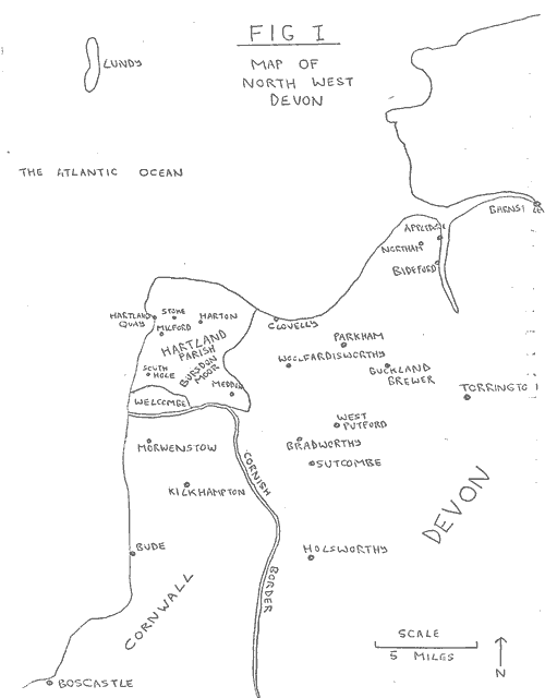
FIG. I: MAP OF NORTH WEST DEVON
Hartland was an early Anglo-Saxon estate mentioned in King Alfred's will [19], while its name was also given to the hundred in which [PAGE (7)] it was situated. The largest manor in the parish was held by the Dynham family from soon after the Norman conquest until 1501; it was this family which founded the Abbey of Hartland in 1169 [20], replacing the college of twelve canons that were mentioned in Domesday Book [21]. This college had been endowed with lands within the original Manor of Hartland, later to be known as Stoke Manor [22]. Domesday Book records three other manors within the parish called Milford, South Hole and Meddon, but they were small parcels of land on the periphery. Hartland church, which stands in the hamlet of Stoke and was the former abbey church, is still the central church for the large parish, despite its position two miles west of the borough of Harton. During the Middle Ages it was the focal point for a network of at least ten chapels. Only St Nectan's of Welcombe now survives, having been raised to separate parochial status in 1508 [23]. Stoke church is also dedicated to St Nectan, a Celtic missionary from South Wales who was reputedly martyred near the site of the church. The patronal festival which falls on June 17th is still an important event in the parish.
The Dynhams were also responsible for the foundation of the borough of Harton circa 1290. The borough charter appears to have been a private seignorial grant with no royal confirmation [24]. Harton is now scarcely more than a large village, but it once supported a larger population than the neighbouring town of Bideford [25]. It was governed by a portreeve who was elected annually by the burgesses; and a weekly market and yearly fair were held, although they appear to have subsided during the later Middle Ages. A second grant, dated 1559, replaced them with a Saturday market and two annual fairs. The latter were held on [PAGE (8)] the Tuesday, Wednesday and Thursday after Easter, and on the eve, feast and morrow of the Exaltation of the Holy Cross (September 14th) [26].
Daniel Defoe wrote an interesting description of the economy of Hartland in 1724, most of which appears to be reasonably accurate, despite his reputation for literary exaggerations.
"The town of Hartland which stands just within the shore and is on the very utmost edge of the county of Devon is a good market town, though so remote, and of good resort too, the people coming to it out of Cornwall, as well as out of Devonshire. . . . . . the seamen go on shore here and supply themselves with provisions; nor is the town unconcerned in that great gainful fishing trade, which is carried on for the herrings on this coast, many seamen and fishing vessels belonging to the town [27]."
A study of the Portreeve Accounts showed that Defoe was correct when he described Harton as a market town for north east Cornwall as well as for north west Devon. At the back of the Portreeve Accounts is a collection of 'testimonies' for the sale of horses, cattle and sheep in Harton market [28]. These testimonies, or records to ensure fair trade, list twenty-seven sales of livestock that were transacted in the market between 1615 and 1621. The Devon farmers who made such transactions came from Hartland itself (34 men), Bradworthy (4 men), Clovelly (2 men), and West Putford, Buckland Brewer, Bideford, Sutcombe and Woolfardisworthy (one each). At least 5 other farmers travelled to Harton market from across the Cornish border: 3 from Morwenstowe and 2 from Kilkhampton. Fig. 2 shows that the maximum known distance travelled by farmers coming to Harton to buy or sell livestock was about fifteen miles, although a more average distance was approximately five miles. The number of livestock sales recorded in the testimonies was almost certainly fewer than the total number of actual sales, but the known figures indicate that approximately 68% of farmers using [PAGE (9)] Harton market came from within Hartland parish, 22% came from the town of Bideford and from rural Devonshire parishes, while 10% came from rural Cornish parishes. There was no specific tendency for farmers coming from outside the parish either to buy or to sell livestock in Harton market: approximately equal numbers came as purchasers and vendors. This was also true of farmers who came from Hartland parish itself. In general, Harton can probably be regarded as possessing a relatively small market catering for short-distance trade, mainly from within its own large parish. Unfortunately, no information was available to indicate the sphere of influence of Harton's two annual fairs, which may have been greater than that of the market. R. Carew in 1602 referred to graziers from Devon and Somerset who fed "yearly great droves of cattle in the north quarter of Cornwall [29]". Harton's two fairs may have played a crucial role (note that one was a Spring fair and the other an Autumn fair) in the operation of this long-distance cattle trade.
In general terms, the sources point towards a mixed farming economy in Hartland during the late sixteenth and early seventeenth centuries. The Dynham Survey of 1566 records the existance of four granary mills on the Dynham manor alone [30], while there were at least two other corn mills elsewhere in the parish. Sea-sand, manure and the practise of 'Denshiring' [31] were used in other parts of Devon during this period to improve the quality of arable land [32], but there is no apparent evidence for their use on Hartland's fields at this time. Sand is a rare commodity on Hartland's rocky coast, while the locally famous Bude sand would have been expensive to transport up to Hartland at this date. However, there is evidence that lime was being burnt in kilns at Hartland Quay. The church accounts state that three shillings [PAGE (10)] were paid for "two barrles of lyme from Mr Abbattes key" in 1602 [33]. Numerous references to lime being brought into the parish from Clovelly Quay also appear in the church accounts after 1591. These consignments of lime were probably for building purposes, but lime was used elsewhere in Devon as a fertilizer, although it was spread on pastureland as well as on arable fields.
The best evidence for the existence of arable farming in Hartland during this period is the information on land-use in the Dynham Survey of 1566. The latter shows that barton and customary tenants of the Dynham manor were farming 3,581 acres of land, of which 3,115¼ acres were classed as arable, 93 acres were meadowland and 378¾ acres were moorland [34]. It is clear, on the other hand, that the term 'arable' does not have its modern meaning, but was used in the sense of 'capable of being ploughed' or 'fit for tillage'. Finberg points out that "convertible husbandry was the rule in Devon" during the seventeenth and eighteenth centuries [35]. This was the system under which a sequence of crops followed one another on the same ground, to be eventually succeeded by grass for several years. Samuel Colepresse in 1668 claimed that the usual practice was to grow crops for six years followed by grass for at least seven or eight years [36]. Assuming that 'convertible husbandry' was practised in Hartland parish in the mid-sixteenth century, it seems probable that at least half of the 3,115¼ acres of 'arable' recorded in the Dynham survey of 1566 would have been under grass while the remainder were growing crops. It is certain, in any case, that at least 242 acres of this 'arable' land were given over to pasture, since six tenancies of barton land on the Dynham Survey were leased out as 'agistments' or land for grazing cattle [33].
[PAGE (11)]
It could also be argued that a greater proportion of freehold land (about which there is no information on land-use) was given over to pasture. This is because freehold farms were generally situated on the more inland and upland areas of the parish (see Fig 6), where the landscape today is more bleak and is often left as rough moorland.
The farmers of Hartland may also have had access to the rough grazing on Bursdon Moor, although there is no record of this dating from the period under consideration. The Dynham Survey records that Sir John Perrett held the barton tenancy of 'Burresdon Moore' [37], although there is no acreage mentioned for this reference and he may not have had the right to all the grazing there. Certainly, the rent of six shillings and ten pence that he paid for the three tenancies of 'Burresdon Mede, Est Downe and Burresdon Moore' [37] seems very little when the modern acreage of the moor (344 acres) [38] is taken into account.
John Leland, in the early sixteenth century, described Hartland as being "ten miles from Bedeford, much by Morische Ground but very good for Broode of Catelle [39]." The strong presence of pastoral farming within the parish is also indicated on the only Hartland estate map to survive from this period. This map of the hamlet of Stoke and its surrounding fields, almost certainly dating from the 1590s [40], shows that at least some of these fields were used as pasture. One field of 89 acres was called 'Sheepjays', while three smaller fields were called West Horse Park (4 acres), Middle Horse Park (3 acres), and East Horse Park (3 acres). The records of fair trading in the Portreeve Accounts indicate that 53 sheep, 17 lambs, 1 ram, 12 horses, 10 pigs, 3 heifers, 1 steer, 3 yearlings, 15 kyne, 10 cows and 9 oxen [PAGE (12)] were sold in Harton market between 1615 and 1621 [41]. As indicated earlier, these figures do not represent the total numbers of livestock sold in the market during these nine years, but only those for which a record of sale was required. Occasional references appear in the church accounts to sheep being left to Hartland Church by individuals in their wills: two men in 1601, for instance, left one sheep each to the church [43].
Some of the wool from Hartland's sheep was probably exported to the flourishing wool towns of Barnstaple and Torrington, described as such by Thomas Westcote in 1630 [42]. 1t is evident, however, that some local wool was manufactured into cloth within Hartland itself. The Dynham Survey records the presence of a 'tucking-mill' or fulling-mill on the manor [44], while the parish register refers to two 'weavers' and two 'worsted-combers' between the years 1700 and 1706 [45]. 1t is also evident that there were other crafts in Hartland based upon livestock products. Glove-making was the most notable example: five glovers were recorded in the 1546 survey of the former abbey lands [46], in the church accounts in 1619 [47] and in the parish register in 1606, 1611 and 1639 [45]. The Portreeve Accounts show that two pairs of gloves were bought by Harton Borough each year [41], presumably from local craftsmen. These gloves were possibly used at the two annual fairs in some kind of ceremonial context. The making of gloves had also become established in the nearby town of Torrington by the sixteenth century [48]. The gloves made there were fabricated from both wool and leather [48], and it is possible that the Hartland glovers worked in the same two materials. North West Devon can perhaps be regarded as a glove-making area during the period with [PAGE (13)] which this dissertation is concerned.
Evidence exists for the presence of other livestock-product trades in Harton at this time. A tanner is recorded in 1613 [51] and two butchers in 1617 [50] and 1622 [49] respectively.
The available evidence points to a mixed farming economy in Hartland parish between 1558 and 1620, probably similar to that found at Tavistock, in South West Devon, during the early sixteenth century [52]. The poor roads leading inland would have gravely hampered the import of grain from elsewhere, although poor roads were obviously no hindrance to the export of livestock which could be driven on the hoof. Grain crops harvested on Hartland's farms and ground into flour in the local mills were probably for local consumption, whereas livestock and livestock products probably found their way to other parts of England. This is in contrast to some other pastoral districts elsewhere in England which were becoming more and more specialised during the sixteenth and seventeenth centuries. A 'woodland' parish such as Myddle was importing grain during this period, allowing its farmers to concentrate upon pastoral farming [53]. Myddle's farmers did not have to be self-sufficient in grain due to adequate communications with grain-growing areas.
The state of communications between Hartland and other parts of Devon and Cornwall had improved slightly by the late sixteenth century. George Cary built a harbour at the neighbouring coastal village of Clovelly between 1543 and 1601, described by Hoskins as the only safe [PAGE (14)] harbour between Appledore (near Bideford) and Boscastle (south of Bude) [54]. The Portreeve Accounts show that in 1615 Harton Borough paid "12/4d for a tablebord in Bristol, 3/- for carriage to Clovelly and 3d for landing it there [58]". The Abbot family of Stoke Manor in Hartland also constructed a small quay during the last few years of the sixteenth century, about half a mile west of Hartland church (see photograph). Unlike Clovelly pier, the harbour wall at Hartland Quay has now been swept away by the sea, but it was obviously a thriving little port before its demise after 1818. W.G.Maton wrote this description of it in 1794:
"Hartland Quay consists of about a dozen decent cottages, and has a commodious little pier, at which commodities of various kinds, for the supply of this part of the country, are landed from Bideford and Barnstaple [55]."
Hartland Quay was first recorded in the church accounts in 1602, and the same source in 1616 indicates that it functioned as part of the coastal trade even by this early date:
| "pd for a Tunn of lead in Bristol | £12 | |
| pd for haleing of the same from Ratcliffe hill to the barke at Bristol | 12d | |
| pd for custome for the same | 2/- | |
| pd for fraight to Northam | 5/- | |
| pd for landing and carrying of it into Mr Doctons seller | 12d | |
| pd Bate for carryinge aborde the lead at Northam | 4d | |
| pd for carriage of the same at Clovelly Key | 3/6d | |
| pd for landing of it there | 4d | |
| pd for carrying the lead aborde at Clovelly key | 4d | |
| pd for carrying of it to Hartland key | 3/- | |
| pd for carriage of it up into a seller | 6d | |
| pd for carrying of the lead from the key to the church | 20d [56]" |
It must have been difficult landing a cargo at Hartland Quay as the following sailing directions, dating from 1810, make clear:
"the back of the pier is exposed to a terrific sea, which, with southerly winds, cause a violent run inside. To sail in, keep head half a mile off shore until the pier bears SSE half E, then run in [57]."
[PAGE (15)]
However, the same sailing directions show that Hartland Quay could accomodate "two 50-ton sloops and a few fishing boats", so the port must have been able to handle some of the agricultural imports and exports entering and leaving Hartland parish at an earlier period. References to the transport of agricultural produce have not survived from before the eighteenth century, when grain and malt exports were recorded [59].
Thomas Westcote stated in 1630 that:
"our (Devonshire) havens are well replenished with shipping and them employed in merchants' affairs or in fishing voyages, upon our own coasts and elsewhere, as in Canada, Virginia, Newfoundland, or in times of peace into the Straits, Spain or Portugal, and in Clovelly and Linmouth upon our northern coasts for herring, the king of fishes [60]."
Clovelly was the most notable fishing port on the North Devon coast: in 1535 the village paid 26/8d in tithes on fish [61]. The fishing industry at Hartland Quay was established soon after the port was constructed during the late sixteenth century. William Camden mentions Hartland Quay in his 1607 edition of 'Britannia', "off which is a good cod and herring fishery [62]", and Daniel Defoe attests to the presence of this Hartland fishing industry at a later date (see page 8).
TABLE I: THE BASIC LISTING FOR HARTLAND PARISH (1558-1620).
| Initial List. | Presumed Non-Resident. | Presumed Resident. | |
| Families married in Hartland Church: | 327 | 52 (Not recorded elsewhere in Register.) | 275 |
| Families included on Listing from other sources: | 48 | 23 (Not recorded at all in Register.) | 25 |
| TOTALS: | 375 | 75 | 300 |
[PAGE (16)]
CHAPTER 2: A COMMUNITY OF HARTLAND?
This chapter is concerned with the question of whether Hartland parish was an isolated historical community, or whether the strength of its economic and social connections with other parts of Devon and Cornwall negate the validity of regarding the parish as an independant 'self-sufficient' unit. The basic listing on which the chapter is based is a collection of 375 surnames, the great majority of which came from Hartland's marriage register between 1558 and 1620. Forty-eight names were not derived from the latter but were included because the individuals concerned were closely connected with the parish, even though they did not participate in marriages in Hartland church. Almost every person in this smaller sub-group was a tenant recorded in the manorial surveys.
The list of 375 surnames was then compared with the name-index at the back of a printed copy of the Hartland register [63]. It was discovered that 52 of the surnames taken from the marriage register did not occur anywhere else in the Hartland register as a whole. Likewise, 23 of the 48 surnames (which were included on the basic listing from other sources) were not present anywhere at all in the Hartland register (see Table I). Seventy-five names can therefore be seen to represent the core of the relatively large group of individuals who were not resident in Hartland, yet had strong connections with the parish.
It should be stated that these 75 names do not represent the only non-resident families recorded on the initial list of 375 surnames. The criterion for establishing the non-resident status of a man or woman marrying into a Hartland family as outlined above would bias [PAGE (17)] the results in favour of those with uncommon names. Families from other parishes with common names marrying into Hartland families might have borne the same name as other families who were resident in the parish, yet to whom they were not related. However, there was no way in which this bias could be rectified, given the time available.
On the other hand, it was possible to use the Devon muster roll of 1569 to trace the possible parish of origin of some of the 52 non-resident families marrying into Hartland families. Eight of these 52 surnames were apparently held by people of gentry status (the Chappells, Grenvilles, Loves, Lowrs, Militons, Monks, Risedons, and Staveltes). Altogether, there were 9 gentry marriages (2 members of the Chappell family were married between 1558 and 1620), and 8 of them were marriages into the Abbot and Lutterell families. This is of some significance since the Abbots had bought most of the Hartland Abbey estate in 1546 and had become the leading family in the parish [64], while the Lutterells had married into the Abbot family in 1583 and inherited the Abbot estate in 1609 [65]. Both of these families had originally come from outside Devon; William Abbot had been Sergeant of the Cellar to Henry VIII [66], while the Lutterells had come from Somerset [67].
The only non-resident gentry family which married into a Hartland family other than the Abbots and Lutterells were the Chappells. One of their two marriages was with a member of the Seccombe family, another Hartland family with ambitions towards gentry status, as will be seen later.
It has been possible to trace the probable origins of the 8 [PAGE (18)] non-resident gentry families, mainly with the aid of the Heralds Visitations of Devon [68]. Four of them seem to have been local North Devon families. The Chappells probably came from near Barnstaple, the Monks were from Potheridge near Hartland, the Risedons came from Buckland Brewer [71] about ten miles from Hartland, while the Staveltes came from an estate near South Molton. The connections between the Abbots and the Monks were no doubt strengthened by the fact that William Abbot and Anthony Monk served together as local JPs [69].
The other four non-resident gentry families probably originated from Cornwall. The Loves apparently came from Ugbert, the Lowrs from Trelask [71], the Militons from Pengersick Castle [71], while the Grenvilles lived at Stowe, just across the county border south of Hartland. It can be seen, therefore, that the two leading gentry families in Hartland were marrying their sons and daughters into gentry families from Devon and Cornwall, perhaps trying to mask their own more 'foreign' origins, as part of a process of seeking acceptance from among the gentry communities of both counties.
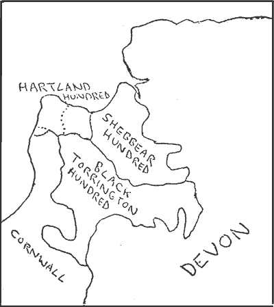
FIG. 3: MAP SHOWING THE BOUNDARIES OF THE HUNDREDS OF NORTH WEST DEVON.
The origins of most of the remaining 44 non-resident families which married into Hartland families can be located through the use of the 1569 Devon muster-roll. The latter lists male names by parish throughout all of the hundreds of Devon, and the surname index at the back of the printed edition [70] was used in order to locate the possible parochial origins of the 44 non-gentry families mentioned above. The 44 surnames were compared with the names on the muster-roll from the three hundreds of Hartland, Shebbear and Black Torrington which cover a wide area of North Devon, almost 400 square miles in extent. Unfortunately, the printed muster-roll covered Devon only: names of [PAGE (19)] families that came from across the Cornish border could not be traced. Table 2 shows that the possible origins of slightly less than half of the 44 families could not be found on the muster-roll of 1569. It is probable that some of these unmatched names belonged to Cornish families which married into Hartland families, but a considerable proportion of the names were no doubt of families which evaded being recorded on the 1569 muster-roll.
TABLE 2: A COMPARISON BETWEEN THE NAMES OF PRESUMED NON-RESIDENT NON-GENTRY FAMILIES RECORDED ON THE HARTLAND MARRIAGE REGISTER (1558-1620) AND SURNAMES ON THE DEVON MUSTER-ROLL OF 1569.
| Names that matched between the non-resident families named above and the Muster-Roll entries for | ||
| Hartland Hundred (Not Hartland parish): | 3 | |
| Shebbear Hundred: | 13 | |
| Black Torrington Hundred: | 3 | |
| The remaining hundreds of Devon: | 6 | |
| Those names that could not be matched: | 19 | |
| TOTAL: | 44 |
Nineteen out of the 44 names of non-resident families were recorded in parishes within the hundreds of Hartland (apart from Hartland parish), Shebbear and Black Torrington (see map). It is of great interest that the inhabitants of Shebbear hundred were over four times as likely to marry into families from Hartland parish than the inhabitants of Black Torrington, especially when it is remembered that the area covered by the latter is considerably greater than that covered by Shebbear hundred. This phenomenon may perhaps be explained by the probability that Shebbear hundred supported a denser population than Black Torrington hundred. It is also true that there were better communications by sea and road between Hartland parish and Shebbear hundred, than between the former and the hundred of Black Torrington. It might also be possible to explain this marriage linkage by investigating the sphere of influence of local market towns. For instance, the inhabitants of Black Torrington hundred might have been more inclined to look southwards towards their market town of Holsworthy for their marriage partners. The idea of a marriage community or a group of parishes linked by marriages between partners from different villages has been explored by Alan Macfarlane [72], and it seems possible to claim that the hundreds of Hartland and Shebbear formed such a community during the early modern period.
[PAGE (20)] Having said this, it must be stressed that the number of marriages involving outsiders was low when compared with the total number of marriages that took place in Hartland church between 1558 and 1620. Altogether, 60 individuals from 52 non-resident families married partners from Hartland families, while 1,130 individuals (excluding the marriage partners of the non-resident individuals) from resident Hartland families were married in their parish church. On the other hand, the figure of 52 non-resident families could probably be enlarged by another 8 names belonging to families which, according to the muster-roll of 1569, lived in the neighbouring parishes of Woolfardisworthy (6 names), Welcombe (1 name) and Clovelly (1 name). These families appeared so constantly in the Hartland register that they were presumed, at first, to be resident Hartland families. However, it appears that they were families which had close connections with their Hartland neighbours and which were constantly marrying amongst them.
TABLE 3: THE RESIDENT OR NON-RESIDENT STATUS OF TENANTS ON THE DYNHAM MANOR IN 1566.
| Non-Resident. | Resident. | Totals. | |
| Free Tenants: | 16 | 44 | 60 |
| Customary Tenants: | 1 | 52 | 53 |
| Barton Tenants: | 2 | 34 | 36 |
| --- | --- | --- | |
| 19 | 130 | 149 |
It is clear that Hartland parish was by no means an isolated community. Some of its inhabitants were finding marriage partners elsewhere, although there were still large numbers of local men and women who were content to marry someone from within their home parish. It has also been shown (see page 8) that there were economic ties between Hartland and neighbouring parishes: this is clear from the evidence of farmers buying and selling livestock in Harton market hetween 1615 and 162 I. There was also Hartland's inclusion within the North Devon coastal trade after the opening of Hartland Quay during the late sixteenth century (see pages 13 - 15). Added to this, it is evident that several individuals also rented land in Hartland but were not resident in the parish. Nineteen of the tenants recorded on the Dynham Survey of 1566 had surnames that did not appear at all in [PAGE (21)] the Hartland register. Altogether, 198 separate tenancies were recorded; 92 of which were of freehold land, 60 of customary land and 46 of barton land [73]. Some of these holdings were rented by the same man, so in practise there were 60 free tenants, 53 customary tenants and 36 barton tenants. Table 3 shows that approximately one-seventh of all tenants on the Dynham Survey could be described as non-resident landholders. Most of these individuals could be traced to their probable parishes of origin [74]. Five of them were local men and came from families living in Monkleigh (1 family), from Hatherleigh (2), and from Bideford (2). Seven individuals probably came from further afield: from near Barnstaple (1), from near Launceston (1), from near Torrington (2), from near Crediton (1) and from near Exeter (2). The remaining 7 individuals could not be traced, but they may have originated from Cornwall. All the names that could be traced were of gentry status, except for two individuals, one of whom was probably an Exeter merchant and the other a yeoman from Hatherleigh. It would appear that most of these non-resident gentry tenants rented out their land to sub-tenants, but there is a possibility that a few of them may have been long-distance graziers (see the quote by R. Carew on page 9) who used this land for feeding herds of cattle at certain times of the year. It was certainly not unusual for the Devonshire gentry to hold land in many different parishes: Hoskins has shown that many gentry families held about ten farms, besides their home manor or farm, scattered throughout several different parishes [75]. This was usually the result of past marriages bringing different parcels of land into the grasp of one gentry family [76].
There is considerable evidence from other parts of England for [PAGE (22)] the existence of a strong degree of occupational mobility among the lower sections of sixteenth and seventeenth century society [77]. It is also clear that only the propertied and landed classes tended to sink their roots in their home village, a finding which is supported by Hoskins in his studies of Devon [78]. Hoskins believed that this was the reason for the fact that 60% of surnames disapeared from the records every hundred years in the parish of Parkham [78], only five miles from Hartland. Mobility has also been considered in David Hey's study of Myddle. He pointed towards the large number of families moving into Myddle during the sixteenth and seventeenth centuries, taking advantage of the areas of waste-land still waiting to be cultivated in the parish [79]. Hartland seems to present a different case. A certain proportion of its population looked beyond the parish for employment as well as for marriage partners. Fig. 4 indicates that the number of births in Hartland between 1558 and 1620 was generally higher than the number of burials. It can be argued that baptism figures in parish registers should be increased by about 10 % and burial figures by 5% to allow for unrecorded baptisms and burials [80], so this would increase the proportion of births to deaths even further. It can therefore be assumed that Hartland's adult population was increasing fairly rapidly during this period, and that there was almost certainly a degree of emigration away from the parish. There cannot have been much incentive for younger sons or farm labourers to stay in Hartland when the population was rising at a time when agriculture was probably not expanding due to the scarcity of cultivable waste-land. Hartland's unemployed inhabitants were almost certainly attracted by increasing work prospects in the [PAGE (23)] textile industries of Barnstaple and Torrington, or in the expanding ports on the Torridge estuary such as Bideford and Appledore. G. Finch also noted the attraction of the expanding ship-building industries on the Torridge estuary, which were growing due to the development of the North American trade at this time [81]. lt has to be remembered that Bideford's population probably grew from approximately 100 people during the 1560s to about 1,650 people by the 1630 [82]. These statistics can be compared with the estimated population figures for Hartland during this period. Finch believes that the parish's population had reached a figure of 1,200 people by the mid-sixteenth century; thereafter it very gradually declined until the end of the seventeenth century [82].
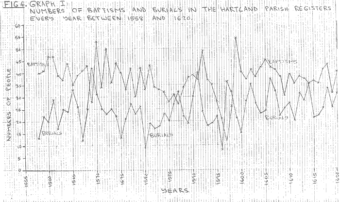
FIG. 4: GRAPH I - NUMBERS OF BAPTISMS AND BURIALS IN THE HARTLAND PARISH REGISTERS EVERY YEAR BETWEEN 1558 AND 1620.
The lives of the inhabitants of Hartland were periodically upset by crisis, of both local and national origin, during this early modern period. E.A. Wrigley has made a short demographic study of Hartland and has remarked upon the "comparitive tranquility for Hartland's population story [83]." However, the evidence from this dissertation differs slightly from his conclusion that Hartland's remoteness from the chief highways of the kingdom no doubt helped to preserve the parish from plague and other epidemic diseases [83]." Hartland may have been a relatively remote parish but its connections with the outside world were adequate enough to permit the introduction of outside epidemics. Fig. 4 shows that the two lines indicating baptisms and burials approached or crossed each other at least eight times between 1558 and 1620. The more serious crises that are suggested by this fact were apparently in 1569, 1581, 1591, 1591, 1598 and 1614. These were the years when the numbers of burials in the parish exceeded the numbers of [PAGE (24)] baptisms. Fig. 5 , which indicates the takings at the two annual fairs in Hartland, also shows at least two points of crisis during this later period from 1612 to 1645. An entry in the Portreeve Accounts in 1624 states: "att Hollirood fair daie we kept noe fair in regard of the affection of the plague in divers parts of the shire [84]." Clearly, the burgesses of Hartland were not convinced that their rural isolation would insure them from the threat of 'plague' [85]. 1624 appears to have also been a bad year for the Easter Fair which showed very low receipts. The burial figures in the Hartland register between 1620 and 1625 show a high peak of 43 burials in 1622 (the highest annual figure recorded since the register was first opened in 1558), followed by a fall to 21 burials in 1623, a rise again to 27 in 1624 (the year of the slump in fair receipts) and then 23 in 1625. Fig. 5 also shows a marked fall in 1621 from the level of receipts taken between 1617 and 1620. Therefore the period from 1621 to 1625 may have been a crisis that lasted for several years. The 'plague' might have struck Hartland itself in 1622, but it was obviously the effects of this epidemic occurring elsewhere in Devon that kept the fair receipts so low for 1624.
The second crisis indicated in Fig. 5 was of a different nature; the outbreak of the Civil War in 1642. It was presumably this national crisis which sent the level of receipts taken at Hartland's two fairs plummetting downwards after 1641. Receipts at the Holirood Fair during 1643 and 1644 were especially low, although receipts at the 1643 Easter Fair made a considerable recovery from their level in 1642. Finch might argue (if he had used the Portreeve Accounts in his study) that the downturn in receipts after the Easter Fair of 1643 was probably caused by another outbreak of plague in Hartland in the summer of 1643. He noted that the Hartland register for 1643 gives a figure [PAGE (25)] of 69 burials (twice the annual average during the 1640s) and that these deaths mainly occurred during the summer months when 'plague' was most prevalent [86]. Deaths in normal years were most common during the winter months as far as Hartland was concerned, apparently because of the numbers of rural poor who were unable to survive hard winters [86].
It can therefore be concluded that the parish of Hartland was not an isolated rural community, but that its economic and social connections with Cornwall and other parts of Devon brought it into constant contact with the outside world. This was certainly true during the period between 1558 and 1620. It can also be concluded that the community of Hartland was not strictly confined to an area within the parish boundaries. Considerable numbers of individuals from Hartland had family, trade and land-tenancy connections with other parts of Devon and Cornwall: the Hartland community, in certain senses, extended beyond the parish boundaries. In many ways, the inhabitants of Hartland also looked towards smaller units within the parish for their sense of community. The links between surnames and place-names in the Hartland register indicates that individuals were identified with hamlets and farms scattered around the parish rather than with the parish itself. The boundaries of the community of Hartland were therefore not rigidly fixed but extended over different areas according to the themes studied. Hartland's marriage community, for example, extended far beyond the parish boundaries, while most of the inhabitants of the parish probably envisaged 'home' as a farm or hamlet rather than the whole parish itself.
[PAGE (26)]
CHAPTER 3: SOCIAL STRUCTURE: HOLDERS OF LAND.
The original list of 375 surnames of families (mainly recorded in the marriage section of the parish register between 1558 and 1620) can now be shortened to a list of 292 surnames after the removal of the non-resident families discussed in Chapter 2. Table 4 shows that approximately half of these 292 families are known to have owned or rented land in the parish between 1546 and 1620. However, there was also a considerable number of families which presumably did not bold land and for whom no occupations are known. This can be explained in the following way. Ninety-two of these families were recorded only in the Hartland register, and they were presumably part of the poorer section of the parish population, probably farm labourers and servants who were too 'socially insignificant' to appear on other records. A few of these 92 families may have been non-resident to the parish, having possibly been missed by the procedure used in Chapter 2 to identify non-resident status. However, 27 families which presumably did not hold land and had no known occupation were recorded in other sources besides the Hartland register (see table 5). It would appear to be difficult to explain this figure of 27 families as they were recorded in sources that show they were of sufficient social status to be appointed parish officials, to be allocated a pew in Hartland church or to appear on the muster-roll of 1569. It is possible that some of them may have held land but were not recorded on the four manorial surveys. For instance, they may have only rented land on the manors of Meddon, South Hole and Milford but were not linked with those manors in the parish register. It is also quite likely that 22 of these families (excluding those recorded on the muster-roll) might have moved into the parish and taken out tenancies of land after 1577 (the date of the last manorial survey). This is because the sources on parish officials [PAGE (27)] and the church pew-list do not commence until the 1590s. This does possibly indicate a certain level or fluidity among the landholding section of Hartland's population, as old families died out or moved away from the parish and new families moved in to take their place.
| TABLE 4: PATTERN OF LANDHOLDING AND OCCUPATIONS IN HARTLAND PARISH (1546-1620). | |
| Known landholding families: | 150 |
| Families not holding land known to be craftsmen, shopkeepers and labourers: | 22 |
| Families not holding land and of unknown occupation: | 119 |
| Family of parson: | 1 |
| TOTAL: | 292 |
| TABLE 5: HARTLAND FAMILIES NOT HOLDING LAND AND OF UNKNOWN OCCUPATION. | |
|  : | |
| Families recorded only in Register: | 92 |
| Families on 1569 Muster-Roll and Register: | 5 |
| Families on list of Churchwardens and Register | 5 |
| Families on other lists of parish officials and Register: | 1 |
| Families on 1613 Pew List and on Register: 16 | |
| TOTAL: | 119 |
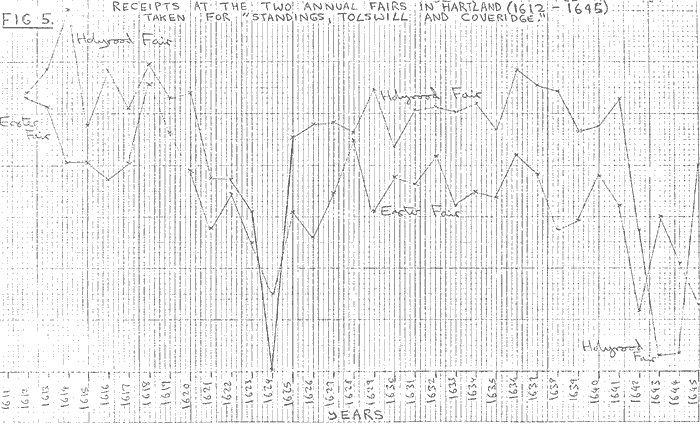
FIG 5: RECEIPTS AT THE TWO ANNUAL FAIRS IN HARTLAND (1612-1645) TAKEN FOR "STANDINGS, TOLLSWILL AND COVERIDGE".
| TABLE 6: TENANTS LISTED IN THE DYNHAM SURVEY OF 1566. | |||
| GROUP A: | |||
| Names | No. of Freehold Tenancies | Acreage of Barton and Customary Tenancies | Social Status (when known) |
| 1. William Abbot | 111 acres | Esquire | |
| 2. John Atkin | 141 acres | ||
| 3. Thomas Cholwell | 2# | Gent | |
| 4. Phillip Cole | 4 | Esquire | |
| 5. Robert Cole | 213 acres | Gent | |
| 6. Thomas Cook | 2 | 20 acres | |
| 7. John Dayman | 2 | ||
| 8. Alice Davy wid | 2 | ||
| 9. John Hele | 2 | ||
| 10. John Kempthorne | 2 | 4 acres | Gent |
| 11. Richard Knapman | 2 | ||
| 12. John Nicoll | 3 | ||
| 13. Robert Nicoll | 1 | 131 acres | |
| 14. Hugh Pollard | 7 | Gent | |
| 15. Hugh Prust (Therry) | 2 | Gent | |
| 16. Hugh Prust (Wullesworthy) | 2 | ||
| 17. Hugh Prust (Gorvin) | 3 | Gent | |
| 18. Katherine Prust wid | 2 | ||
| 19. John Seccombe | 3 | Gent | |
| 20. John Short | 105 acres | ||
| 21. Christopher Sincock | 2 | ||
| 22. Hugh Stucley | 125 acres | Gent | |
| 23. John Tuckar | 104 acres | Gent | |
| 24. Thomas Velly | 2 | 20 acres | |
| GROUP B: | |||
| 1. Roger Adam | 1 | ||
| 2. Heir of Berryman | 1 | ||
| 3. Bartholomew Bery | 1 | Gent | |
| 4. Anthony Bery | 1 | Gent | |
| 5. John Blagdon | 1 | ||
| 6. Edward Cleverdon | 1 | ||
| 7. William Cole | 1 | ||
| 8. John Dayman | 1 | ||
| 9. John Dennis | 1 | ||
| 10. John Docton | 1 | Gent | |
| 11. Nicholas Elliott | 1 | ||
| 12. John Gyfford | 1 | ||
| 13. Beatrix Hooper | 1 | ||
| 14. John King | 1 | ||
| 15. William Praunce | 1 | ||
| 16. Thomas Rowe | 1 | ||
| 17. John Ryder | 1 | ||
| 18. Thomasine Saunder | 1 | ||
| 19. Agnes Short wid | 1 | ||
| 20. Heir of Thorne | 1 | ||
| 21. Heir of Velly | 1 | ||
| 22. Joanna Velly | 1 | 7 acres | |
| 23. John Wellesford | 1 | ||
| 24. Robert Wilcock | 1 | ||
| 25. William Witheridge: | 1 | ||
| 26. Richard Younge | 1 | ||
| GROUP C | |||
| 1. Alice Atkin | 56 acres | ||
| 2. Joanna Atkin | 64 acres | ||
| 3. Thomas Avery | 45 acres | ||
| 4. Thomas Avery jun. | 14 acres | ||
| 5. Edward Bagelhole | 39 acres | ||
| 6. George Bagelhole | 12 acres | ||
| 7. Henry Bagelhole | 38 acres | ||
| 8. William Bagelhole | 76 acres | ||
| 9. William Bagelhole | 25 acres | ||
| 10. John Buse | 12 acres | ||
| 11. John Buse | 72 acres | ||
| 12. William Butler | 21 acres | ||
| 13. John Clement | 29 acres | ||
| 14. Joanna Clement | 29 acres | ||
| 15. Agnes Dayman wid | 22 acres | ||
| 16. John Dayrnan jun | 45 acres | ||
| 17. Alice Docton wid | 70 acres | ||
| 18. John Docton sen | 12 acres | ||
| 19. Thomas Docton | 19 acres | Gent | |
| 20. Richard Downe | 20 acres | ||
| 21. John Galsworthy | 45½ acres | ||
| 22. Peter Hallett | 13 acres | ||
| 23. John Hatherleigh | 17 acres | ||
| 24. William Hatherleigh | 40 acres | ||
| 25. John Holeman | 21 acres | ||
| 26. Thomasine Holeman | 37 acres | ||
| 27. William Huckmore | 16 acres | ||
| 28. John King | 66 acres | ||
| 29. Katherine Lange | 35 acres | ||
| 30. Thomas Maye | 39 acres | ||
| 31. William Maye | 27 acres | ||
| 32. Hugh Mongey | 24 acres | ||
| 33. John Nicoll sen | 39 acres | ||
| 34. John Nicoll | 36 acres | ||
| 35. Thomas Nicoll | 28 acres | ||
| 36. Nicholas Penhorod | 41 acres | ||
| 37. Roger Penhorod | 29 acres | ||
| 38. John Perde | 23 acres | ||
| 39. Alice Prust wid | 41 acres | ||
| 40. John Prust | 40 acres | ||
| 41. Thomas Prust | 46 acres | ||
| 42. John Randel | 32 acres | ||
| 43. Isabella Reade wid | 53 acres | ||
| 44. William Rodde | 18 acres | ||
| 45. William Rowe | 55 acres | ||
| 46. John Saunder | 43 acres | ||
| 47. Katherine Sherme wid | 24 acres | ||
| 48. Hugh Snowe | 32 acres | ||
| 49. John Snowe | 53 acres | ||
| 50. Martin Snowe | 28 acres | ||
| 51. Petrock Snowe | 35 acres | ||
| 52. Thomas Snowe | 30 acres | ||
| 53. William Threwe | 82 acres | ||
| 54. John Vine | 54 acres | ||
| 55. Peter Walden | 35 acres | ||
| 56. John Walsh | 37 acres | ||
| 57. Elizabeth Wilke wid | 44 acres | ||
| GROUP D: | |||
| 1. Elizabeth Bagelhole | 5 acres | ||
| 2. Peter Bagelhole | 1 acre | ||
| 3. John Crang | 2¼ acres | ||
| 4. Mark Dayman | 5 acres | ||
| 5. William Hamlyn | 5 acres | ||
| 6. Richard Jesse | 5 acres | ||
| 7. Alice Lake wid | 2 acres | ||
| 8. Richard Pedwyn | 3½ acres | ||
| 9. John Prust | 3 acres | ||
| 10. Henry Tucker | 4 acres | ||
The manorial structure of Hartland parish was very complex in the sixteenth century. Six different manors were located within the parish: the large Dynham manor which covered most of the parish, the former Abbey estate held by the Abbot and Lutterell families successively, the former Abbey lands held by the Smiths arter 1517, and the three ancient but small manors of Kilrord, Meddon and South Hol This pattern was made more complicated by the inclusion of a large portion of the neighbouring parish of Woolfardisworthy within the Dynham manor (see Fig.6). There was a discernible pattern to the location of freehold, customary and barton farms within the Dynham manor. Fig.6 shows that there was a tendency for freehold farms on the Dynham manor to be located on the more remote and upland areas of Hartland parish. Only freehold farms were to be found on the section of the manor that was situated outside the parish boundaries; and there were more freehold farms in the southern half of the parish than in the northern half. Barton land was scattered in roughly equal quantities in both the southern and northern halves of the parish, but there were many more customary tenancies in the northern half (44) in comparison with the southern half (9). This possibly has some connection with the settlement history of the parish. The northern half of the parish was probably the area that was first settled and farmed: the large number of customary tenancies are possibly the feudal relics of this early medieval period. The location of the freehold farms perhaps marks a later settlement period, when waste-land on the inland areas of the parish was colonised during the years of land-hunger in the twelfth and [PAGE (28)] thirteenth centuries. The barton tenancies were probably parcels of land that had been reserved by the Dynham landlords for their own use, until recent years; perhaps until the death of the last Lord Dynham in 1501 [87].
Only the Dynham Survey of 1566 gives detailed information on tenancy customs maintained on the manor, but it is probable that the other five manors used similar arrangements. The tenancy customs recorded at the back of the Dynham Survey were generally concerned with the claims that could be made upon freehold and customary tenants by the Lords of the Manor (the estate had been divided among the four daughters of the last Lord Dynham after 1501) [87]. For instance, it is clear that freeholders as well as other tenants had to attend the manor court: "Item, the said lordes may kepe 2 lawes dayes and 2 Courtes of the Manor every yere, unto which all tenauntes, as well free as customarye, shall sewe." [88] Freeholders had to perform no other duties, but customary tenant families had to pay a 'heriot' (their best beast) upon the death of each tenant, while "the custome of the said manor is that the lordes may graunte their customary landes for terme of three lives." [88] This is the reason why three names, as well as the tenant's name, usually appear on the list of customary tenants in the Dynham Survey.
The barton tenants were not mentioned on the list of manorial customs. However, it is clear that they were treated, in terms of leases, in a similar fashion to the customary tenants: they rented land under the three lives system and gave detailed information about their holdings in the same manner as the customary tenants.
It is possible to construct a model of social structure (based [PAGE (29)] upon landholding) for the parish of Hartland by using the detailed information in the Dynham Survey of 1566. Altogether, 69 out of the 150 resident landholding families recorded on Table 4 were listed on the Dynham Survey. Table 6 shows the 117 individual tenants taken from these 69 families. They have been divided into groups according to the amounts of land they are known to have rented. Of course, the size of each freehold farm is an unknown factor: the only clue given for this in the Dynham Survey is the fact that William Praunce's freehold farm was divided into three tenements or small-scale farms [89]. However, one can be certain that those tenants with two or more freehold farms can be placed in Group A which contains all Dynham tenants with holdings of 100 acres or more in extent. Group B contains all the freehold tenants with single holdings: some of these tenants could almost certainly be placed in Group A while others would probably be placed in Group C, if the size of these freehold farms was known. Group C contains all the tenants with barton and customary land of between 5 and 100 acres in extent. Group D contains those tenants with 5 acres of land or less.
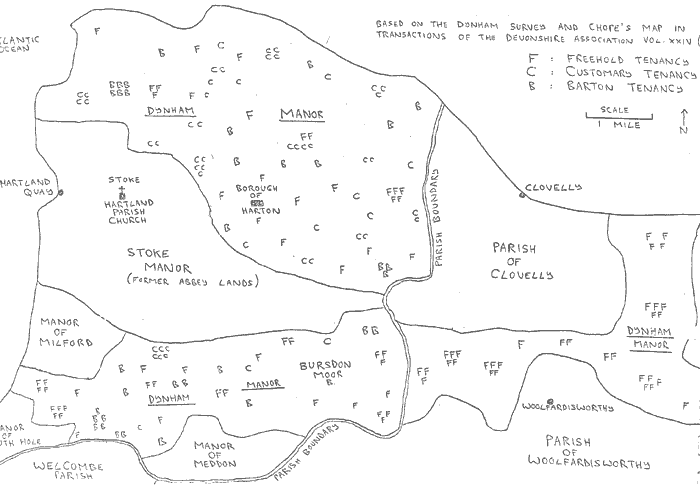
FIG 6: MANORIAL MAP OF HARTLAND IN 1566
The 24 tenants who appear in Group A must almost certainly have formed part of the relatively small body of prosperous gentry and yeomen farmers who would have run parish and church affairs during the late sixteenth century. These were the men who would have become parish and church officials, although there is no direct evidence of this as the sources on parish officials do not commence until 1596 [90].
Fourteen tenants on Table 6 were almost certainly of gentry status, and 10 of these are located within Group A. Three more were tenants of only one freeholding each and have been placed within Group B, but they were probably among those tenants whose lands extended to more [PAGE (30)] than 100 acres in extent. Only one gentleman (Thomas Docton) has been inserted within Group C, as he was recorded as the tenant of only 19 acres in 1566. However, the earliest reference to his gentry status was in 1598 [91], by which time he would probably have inherited another 297 acres of barton land. This is known because Sir John Perrett, tenant of this land in 1566, had named Thomas Docton on the manor 'copy' as the first of three lives who would inherit the land when his own tenancy expired.
The list of 25 men who were assessed as wealthy enough to provide weapons for the 1569 muster was compared with the names on Table 6. Altogether, 21 men taken from the muster-roll list appeared on Table 6 [2]. Ten of them were located within Group A, one within Group B and as many as 10 within Group C. The high number of these men within Group C could be because many of them probably rented land elsewhere or they might have inherited other tenancies by 1569. Thomas Avery junior held only 14 acres on the Dynham manor in 1566, but he was the first successor on the manor copy to another 46 acres held by John Atkin, and second heir (after his mother) to his father's (Thomas Avery senior) 45 acres. William Butler had at least another 12 acres of land (he was apparently the tenant of former chantry lands belonging to Hartland church) [93], besides the 21 acres that he held on the Dynham manor. John Holeman probably held another tenancy elsewhere as his name was linked with a different farm in the Hartland register in 1566 [94]. John Randel was likewise connected with another farm in the register in 1578) [94], while William Rowe had married a daughter of the Docton family in 1563 [94] and his wealth was possibly enlarged by the addition of his wife's property. The point that emerges here is that it is difficult to attain a completely [PAGE (31)] accurate picture of relative wealth from the Dynham tenant-list on Table 6. However, many of the tenants in Group A were obviously of considerable wealth, despite the validity of Table 6 as an accurate model of social structure being questioned. Many of these men must have owned or rented estates amounting to several hundred acres each. This is certainly true of William Abbot, the two Coles and Hugh Pollard. Indeed, the Dynham tenancies held by these men, with the probable exception of Hugh Pollard who held seven freehold farms, must have made a relatively small contribution towards their total wealth. John Seccombe with his three freehold farms also possessed a sound economic base for his gentry status. It may be remembered that a relative of John Seccombe (possibly his daughter) was the only member of the parish, besides eight individuals from the Abbot and Lutterell families, to marry a partner from a non-resident gentry family between 1558 and 1620.
It is clear from the records that a title denoting gentry status could be assumed by the inhabitants of Hartland at this time for different reasons. There were the leading gentry families, recognised as belonging to that status by other members of the county community of gentry. The Abbots and Lutterells were the leading examples in the parish, as is indicated by the number of their marriages with non-resident gentry families from Devon and Cornwall. Their sons were called 'magister' or 'Mr' in the Hartland register, and they claimed the most prestigious pews in the parish church (see chapter 5). The Seccombes and Doctons were probably approaching the same level during the course of the later sixteenth century. Thomas Docton, the tenant of a mere 19 acres of land in 1566, was called 'esquire' on the 1613 Pew List [95], while his wife (Alice) was recorded as 'Mrs Docton' [96]. Alice [PAGE (32)] Docton obviously became a leading figure in the parish during her old age. In 1613 she paid for the erection of the royal coat-of-arms in Hartland church [97], while her tombstone on the chancel floor (dated 1619) records that she left £20 in her will for the benefit of the parish poor.
The example of social mobility left by Thomas Docton was copied by several other prosperous yeomen of the parish. These were the men who were eventually awarded the title of 'gent' by their own local community if not by the county at large. William Hooper, probably a descendant of Beatrix Hooper (tenant of a single freehold farm in 1566), was called 'gent' on the 1613 Pew List, but his social status was 'disclaimed' by the Herald's Visitation of 1620 [98]. Thomas Cholwell, tenant of two freehold farms in 1566, was referred to as a 'gent' in 1613 [101]. Hugh Prust of Gorvin, tenant of three freehold farms in 1566, was a 'gent' who played a prominent part in parish affairs. He was an Overseer of the Peer in 1604 [99] and Church Treasurer in 1613 [100]; his latter position was given due recognition when the pews erected in the South Chapel of Hartland church in 1613 were carved with his initials 'H.P.' (see photograph). With possibly four others, these were the prosperous local yeomen who, due to their personal prestige, were climbing the social ladder to be counted among the ranks of the parish gentry by the early seventeenth century.
TABLE 7: AMOUNTS OF LAND HELD BY DYNHAM TENANTS IN GROUP C ON TABLE 6:
| Acreage | Numbers of Tenants |
| 91 - 100 acres | 0 |
| 81 - 90 acres | 1 |
| 71 - 80 acres | 2 |
| 61 - 10 acres | 3 |
| 51 - 60 acres | 5 |
| 41 - 50 acres | 9 |
| 31 - 40 acres | 13 |
| 21 - 30 acres | 14 |
| 11 - 20 acres | 10 |
| 6 - 10 acres | 0 |
| Total: 57 tenants in Group C. |
TABLE 8: HARTLAND DAY LABOURERS (1612-1620)
| Names | 1612 | 1613 | 1614 | 1615 | 1616 | 1617 | 1618 | 1619 |
| Henry | 1 day: 11d | |||||||
| Barrie | (Harton) | |||||||
| Thomas | 1 day: 15d | 4 days: 36d | 1 day: 9d | |||||
| Beare | (Harton) | (Harton) | 1 day: 9d | |||||
| 1 day: 8d | ||||||||
| (Harton) | ||||||||
| Phillip | Annual: 28d | Annual: 30d | Annual: 32d | Ann.: 32d | ||||
| Blackbeare | (Harton) | (Harton) | (Harton) | (Harton) | ||||
| Abraham | 2 days: 22d | 3 days: 36d | 2 days: 26d | 3½ days: 21d | ||||
| Bond | (Church) | (Church) | (Harton) | (Harton) | ||||
| 6 days: 68d | 4½ days: 27d | |||||||
| ½ day: 6d | (Harton) | |||||||
| 10 days: 110d | ||||||||
| 2 days: 25d | ||||||||
| (Harton) | ||||||||
| Henry | 20 days: 214d | |||||||
| Borne | (Harton) | |||||||
| Brett | 2 days: 16d | |||||||
| (Church) | ||||||||
| Thomas | ½ day: 4d | |||||||
| Cann | (Harton) | |||||||
| Lewes | 1 day: 8d | |||||||
| Cowch | (Church) | |||||||
| Phillip | 1½ days: 18d | |||||||
| Cowch | (Harton) | |||||||
| Heard | 2 days: 26d | |||||||
| (Harton) | ||||||||
| John | 8 days: 80d | |||||||
| Juell | 1 day: 10d | |||||||
| (Church) | ||||||||
| Henry | 1½ days: 18d | |||||||
| Lang | 1 day: 8d | |||||||
| ½ day: 6d | ||||||||
| (Harton) | ||||||||
| John | 4 days: 54d | |||||||
| Lendon | 2 days: 24d | |||||||
| (Harton) | ||||||||
| Justinian | 10 days: 120d | |||||||
| May | 2 days: 20d | |||||||
| (Church) | ||||||||
| Richard | 2 days: 18d | 3 days: 36d | 4 days: 48d | |||||
| May | (Church) | 3 days: 33d | (Church) | |||||
| (Church) | ||||||||
| 2½ days: 30d | ||||||||
| 2½ days: 30d | ||||||||
| (Harton) | ||||||||
| William | 2½ days: 26d | 4 days: 48d | 1 day: 12d | 4 days: 51d | 5½ days: 66d | 1 day: 13d | ||
| May | 2 days: 24d | (Church) | (Church) | 6 days: 72d | 4 days: 48d | (Church) | ||
| (Church) | 2 days: 24d | 9 days: 108d | 11 days: 132d | |||||
| 3 days: 36d | 11 days: 132d | 11 days: 132d | ||||||
| (Harton) | 1 day: 12d | 5 days: 60d | ||||||
| 6 days: 72d | 3 days: 36d | |||||||
| 1 day: 12d | (Church) | |||||||
| (Church) | ||||||||
| 1 day: 12d | ||||||||
| 2½ days: 30d | ||||||||
| (Harton) | ||||||||
| Lawrence | 1 day: 8d | |||||||
| Nicoll | (Harton) | |||||||
| Leonard | 1 day: 14d | |||||||
| Nicoll | (Church) | |||||||
| John | 1 day: 8d | 3 days: 24d | 1 day: 8d | |||||
| Praunce | (Harton) | (Harton) | 6 days: 27d | |||||
| ½ day: 3d | ||||||||
| (Harton) | ||||||||
| John | 1 day: 14d | |||||||
| Prust | (Church) | |||||||
| Hugh | 1 day: 8d | |||||||
| Robin | (Harton) | |||||||
| 1 day: 6d | ||||||||
| (Church) | ||||||||
| John | 2 days: 26d | 1 day: 14d | 1 day: 14d | 2 days: 24d | ||||
| Saunder | (Harton) | 1 day: 13d | (Church) | (Church) | ||||
| (Harton) | ||||||||
| 2 days: 28d | ||||||||
| (Church) | ||||||||
| John | 5 days: 65d | 1 day: 14d | 3 days: 42d | 3 days: 42d | ||||
| Stapledon | (Harton) | (Harton) | (Harton) | 1 day: 14d | ||||
| (Harton) | ||||||||
| John | 1 day: 14d | |||||||
| Walden | 2½ days: 14d | |||||||
| (Church) | ||||||||
| Simon | 1 day: 10d | |||||||
| White | 3 days: 30d | |||||||
| (Church) | ||||||||
| P. Veale | 1 day: 9d | |||||||
| (Harton) |
Other members of the parish gentry did not appear to play such a striking part in local affairs. The claims to gentility made by men such as the two Berys, John Kempthorne, the two Coles, Hugh Pollard and Hugh Stucley probably rested upon their membership of a county gentry family with its ancestral home elsewhere. They may have been established upon their estates by generous fathers or elder brothers, or they were [PAGE (33)] possibly younger sons who had married Hartland heiresses. The latter was certainly a course taken by a descendant of Hugh Stucley at a later date, following the example left by Anthony Lutterell who married the Abbot heiress in 1583 [102]. The Stucley family are still the owners of Hartland Abbey, the home of the Abbots in the sixteenth century.
The tenants listed in Group A on Table 6 together with possibly half of the single freehold tenants recorded in Group B (about 37 individuals altogether) can be seen as members of an 'oligarchy' who controlled church and parish affairs during the late sixteenth and early seventeenth centuries. The tenants in Group C together with about half of those in Group B formed the larger group of farmers (about 10 individuals) who probably farmed most of their land themselves and who generally commanded a very moderate income in comparison with the individuals in the first group. Table 7 shows that the majority of tenants in this group held less than 50 acres of land (46 out of 57 tenants); only 11 tenants farmed between 51 and 100 acres, although this proportion might be greater if the farm-sizes of the single freeholdings were known. However, it is clear that, acting on available information, farmers with between 10 and 50 acres of land formed a substantial proportion of the landholding community of Hartland in 1566.
One of the farmers in Group C - John Galsworthy - was an interesting example of this type of small-scale farmer. Ancestor of the famous novelist, his family originated from Buckland Brewer (about ten miles from Hartland) [103]: the first appearance of John Galsworthy's name in the Hartland records is in 1524 [104]. He was recorded as a customary tenant on the Dynham Survey of 1566; as the leasee of 45½ acres (of which 37½ acres were 'arabIe', 2 acres meadow and 6 acres moor), with the reversion to his wife Johanna and his two sons John and Thomas [105]. He was also one [PAGE (34)] of the 25 men who supplied funds for the 1569 muster (his goods were valued at £10 to £20) [106]. A 'John Galsorle' ('worthy' names in Devon were often shortened to 'sery') was named as a churchwarden in 1599 [107]: this was probably his son John by this late date. 'John Galsery' also sat in the North Transept of Hartland church, one of the prestigious areas of the church (see Chapter 5). Finally, the records of fair trading in the Portreeve Accounts state that 'John Galsworthy' bought 17 lambs in Harton market in 1617 [108]. John Galsworthy and his son can be viewed as relatively prosperous members of Group C, small-scale farmers who were wealthy enough to be included on the list of 25 men contributing towards the cost of the 1569 muster. The Galsworthys appear to have climbed the social ladder during the later sixteenth century, to become accepted among the 'oligarchy' of parish office-holders by 1599. Their relative significance in the parish was given symbolic recognition in the location of their church pew in 1613.
John Galsworthy was probably one of the more wealthy farmers in Group C, standing apart from many of the other tenants listed there. At least ten of these men were recorded as potential soldiers in the 1569 muster and they were probably more typical of this group of farmers. These men, as far as the records show, never became parish officials, while the descendants of at least one of them, John Perde, sat in the non-prestigious area of Hartland Church. In 1566, John Perde farmed 23 acres of land (of which 21½ acres were 'arable' and 1½ acres meadow) on a farm called 'Furford' [109]. 'Perd of Farford' was recorded in 1613 as occupying one of the seats in Pew 11 on the South Side of Hartland church [110], an area of only moderate consequence in terms of social prestige.
A distinction has been drawn between the tenants listed in [PAGE (35)] Group C of Table 6 and those listed in Group D who were apparently in possession of only 5 acres of land or less. Several of these tenants, however, had other sources of income and were probably not as poor as Table 6 would imply. William Hamlyn and Alice Lake, widow, were leasees of two granary mills each, while Richard Jesse was the tenant of a fulling-mill [111]. Elizabeth Bagelhole was the first successor to 12 acres of land rented by George Bagelhole [111], besides probably being the wife of John Bagelhole, a glover of Harton [112]. John Crang's 2¼ acres were located in Harton, possibly where his namesake in 1614 rented two Shops [113]. The remaining five tenants may have been members of a class of peasant labourers, the more fortunate section of the labouring population whose wages were boosted by the produce of their few acres. Professor Everitt believes that most rural tenants mentioned in manorial surveys with less than 5 acres of land were of this class [114].
The social structure of Hartland parish was strongly stratified, although the possibility of mobility did exist. A few men owned or rented large acreages of land while a large number rented small farms of less than 100 acres in extent. According to the evidence of Table 6, about one third of the landholding section of the population formed the 'oligarchy' of gentry and yeomen who rented large areas of land and who filled official positions in parish and church. The remaining two-thirds formed a body of small-scale farmers, sometimes supplying candidates for the parish elite. Beneath them were the remaining families in the parish, belonging to craftsmen, shopkeepers, labourers and fishermen, who are the subject of the next chapter.
[PAGE (36)]
CHAPTER 4: SOCIAL STRUCTURE: CRAFTMEN, SHOPKEEPERS, LABOURERS AND FISHERMEN.
The craftsmen and shopkeeper section of the population of Hartland had many family connections with the parish landholders. Approximately 50 out of 292 presumed resident families had some adult members who worked in Harton Borough during this period. At least 39 of these families had surname connections with the landholding section of the parish. It was apparently almost twice as common for a craftsman or shopkeeper to be related to a farmer as not at all. These links between borough and farmland were reinforced by the fact that several craftsmen and shopkeepers were themselves tenants of a few acres of land. At least 5 such individuals can be located in the records. John Kene, tailor, and John Kene, glover, were both tenants of Abbey lands in 1546 [115], while John Dayman of Harton was recorded in 1566 as a free tenant of a farm at Norton [116]. It was shown in Chapter 3 that Elizabeth, the wife of the glover John Bagelhole, was the tenant of 5 acres on the Dynham manor. George Husband, glover, sold a cow in Harton market in 1615, which indicates that his income was supplemented by agriculture [117].
It is possible to firmly identify at least 8 craftsmen who worked on repairs in Hartland church or who practised a trade in Harton Borough during this period. John Bagelhole, George Husband, John Kene, John Nicoll and Can were all glovers, while Thomas Cholwell was a tanner, another John Kene was a tailor, and John Williams was a 'plummer' [118]. Another 7 men can probably be classed as craftsmen as they were employed on specialised tasks in Hartland church between 1597 and 1620. Phillip May mended the church muskets (stored for the musters) in 1597, [PAGE (37)] 1600 and 1607, and made a lock and two keys in 1605 [119]. Thomas Buse mended one of the bell clappers in 1602 [120] while Martyn Husband repaired the challice in 1605 [121]. William May repaired the church organ in 1605 [122], while Humphrey Skitch mended the bells in 1613 [123]. William Deyman and William Buse refurbished the church armour in 1613 and 1618 respectively [124]. Another two probable craftsmen can be added to this group: David Frye and John Hollowford who repaired the Harton town clock in 1612 and 1619 respectively [125].
There were another ten men who owned or rented 'shops' in Harton between 1612 and 1620. It is not known what products were sold in these shops except in the cases of Zachary Brag, who was a butcher [126], and Hugh Hollowford who sold nails and other metal products [127].
Another two residents of Harton stand out from the groups of craftsmen and shopkeepers already mentioned. William Bagelhole was recorded as a merchant in 1615 [127] (the only example in Hartland during this period), and he was clearly a man of substance. He was Portreeve of Harton at least twice (in 1612 and 1619) [127] and he is recorded on the Pew List as sitting in the South Transept of Hartland church, part of the prestigious area of the church (see Chapter 5). John Bagelhole was recorded in 16r1 as "at ye Tree of Harton" [127]. It seems that he was an innkeeper of an inn called the 'Tree', although there is no other evidence to confirm this.
Not all of the buildings used for non-agricultural production were located in Harton Borough. Due to the nature of their source of power, mills were built over streams that flowed through different parts of the parish. At least 7 mills can be located in Hartland between 1558 and 1620, 6 of which were almost certainly for grinding grain. These [PAGE (38)] granary mills were at Eddistone (2 mills), Harton (2 mills), and Etson and Blackpool (one each). Mills were often leased with small parcels of land: the Eddistone mills had 5 acres of land attached to them and Harton mills had 2 acres [128]. The seventh mill in the parish was a 'tucking' or fulling-mill, used in the process of manufacturing cloth. This mill was rented out to Richard Jesse in 1566, together with 5 acres of land [128].
There is evidence that Harton Borough was controlled by a small group of leading town families, just as Hartland parish was dominated by a small group of gentry and prosperous yeomen. Six families supplied candidates for the 10 portreeves who were elected to office between 1612 and 1620. William Bagelhole, merchant, was the portreeve in both 1612 and 1619 (until his death half way through 1619) [129]. The portreeve in 1613 was William Blagdon, a man of unknown occupation although his family did own a shop in Harton [129]. Richard Crang succeeded him in 1614: he had paid rent for a shop in Harton since at least 1612 [129]. Charles Yeo was portreeve in 1615: he came from a prominent merchant family which lived in Northam, near to the thriving ports of Appledore and Bideford. William Yeo of Northam was recorded in the Hartland register in 1587, but it appears that Charles and Justinian Yeo (the latter was portreeve in 1616) were resident in Harton, members of a branch of the family which had probably settled there [130]. Henry Keine was portreeve in 1617, another man of unknown occupation although two of his namesakes were recorded as a glover and a tailor in 1546 [131].The two tenancies of land held by the two John Kenes in 1546 might have been inherited by Henry Keine by 1617. John Nicoll was portreeve in 1618, almost certainly the [PAGE (39)] same man who was recorded as a glover in 1606 [132]. William Bagelhol was appointed for his second term of office in 1619, to be succeeded after his death by John Nicoll (the portreeve of the previous year). Finally, John Blagdon was portreeve in 1620, the member of the Blagdon family, who had owned a shop in 1614 [133].
Seven of the 8 men who were elected Portreeve of Harton between 1612 and 1620 were recorded on the 1613 Pew List, and 4 of them sat in the prestigious part of Hartland church (2 in the North Chapel and 2 in the South Transept). The other 3 portreeves sat near the front of the church: in the second, third and fourth rows in the Nave. The portreeve not recorded on the Pew List was John Blagdon who was elected to office in 1620. He may have been among the group of "sufficient young married men not seated in the life of their parents" who occupied the spare seats in the North Chapel [134]. It is almost certain, therefore, that the Portreeves of Harton were chosen from among the leading Citizens of the borough, most of whom were related to some of the leading yeomen in the parish. Their local prominence was given symbolic recognition in the position of their pews in Hartland church.
The duties of the Portreeves of Harton, as far as can be determined from the Portreeve Accounts, were many and various. The portreeve's year in office commenced on the Feast of St Michael the Archangel (September 29th). Probably his most important duty was to maintain the borough's annual income by exacting tolls on standings at the Easter and Holirood Fairs and at the weekly markets. He also collected rent for three shops (amounting to 44d a year) and for houses and gardens that had encroached upon the town's commonland. He received 31 shillings a year in rent for the 'Shambles', presumably the area of the town reserved for the butchers. The extent of the Shambles' rent [PAGE (40)] is another indication of the importance of pastoral farming in Hartland (see Chapter 1). The portreeves then used this income to maintain the borough buildings (the Shambles, the chapel and the 'Olde Hall') and the town clock and pump. Money was also used to pay for labour to maintain borough property and to clean streets. Some money was also spent on charity and for such duties as paying a man to whip vagabonds. Money was likewise used to pay for the portreeve's ceremonial duties such as his attendance at Quarter Sessions. The Accounts show that the portreeves had to occasionally travel to Holsworthy and Torrington to attend these sessions, although they sometimes paid a fine for dispensation from these duties. For instance, William Bagelhole paid "6d to the Constables" in 1612 to discharge him from two Quarter Sessions.
The portreeve and church accounts, generally speaking, supplied the only information that could be found on the labouring population of Hartland (apart from the probable existence of a few peasant labourers recorded in the Dynham Survey of 1566). William Abbot's notebook of 1605 (see appendix) does, however, give some indication of the controls that were theoretically imposed upon a labourer's life at this time. A labourer in 1605 was expected to work from five in the morning until eight at night between March and September, and from day-break to dusk during the rest of the year. Labourers were also supposed to work for their employers for at least one year and to give three months notice before leaving. They were also supposed to accept "the accustomed wages". There is no real indication, however, whether this labour code was effectively enforced on all of Hartland's farms.
Professor Everitt believes that the approximate size of the English rural labouring population in the early sixteenth century can be estimated from the numbers of individuals assessed on wages rather [PAGE (41)] than upon lands or goods in the 1524 Subsidy [135]. Studies made of 44 parishes in Devon on this basis showed that 36% of their populations could be regarded as labourers [135]. The English labouring population then expanded during the sixteenth and seventeenth centuries to a figure of almost 50% (inclusive of labourers, cottagers and paupers) by the end of the seventeenth century [136]. Hartland's register between 1698 and 1719 when occupations were recorded) showed that about 52% of the recorded entries were for men styled as labourers [137]. It is clear, therefore, that a considerable proportion of Hartland's population is given scant recognition in the parish records between 1558 and 1620.
However, there is some indirect information relating to labourers who occasionally worked in Harton Borough or in Hartland church during the period between 1597 and 1620. The portreeve and church accounts record the names of approximately 50 men who were employed on unskilled labouring jobs in borough or church. Most of these men had surname connections with the 150 Hartland families (mentioned in Chapter 3) who owned or rented land between 1546 and 1620. They were possibly younger sons of small-scale farmers who could not be employed at home. Employment as a labourer in borough or church was never full-time, so these men must have returned to their home farms or found other labouring jobs when their employment ended. They may have also moved to other parishes to look for farm-work.
Table 8 shows the number of days worked each year between 1612 and 1620 by all those labourers who were employed in borough or church on a daily basis. Labourers were also sometimes employed on a piece-work basis for a specific job but these men have been omited from the table. Those men who were employed by the church between 1597 and 1612 have also [PAGE (42)] been omited as the portreeve accounts do not commence until 1612. A comparison between labourers working for church or borough would not be possible until after 1612. Only one man (Phillip Blackmore) out of the 26 labourers listed on Table 8 was employed on an 'annual' basis. In reality, he was only really paid the equivilent of 3 to 4 days work each year. The entries in the portreeve accounts show that he was paid between 28d and 32d during 1612, 1614, 1615 and 1616 for "cleaning the streets this year". He was obviously seen as a fairly regular employee of the borough. In 1617 he was given 6d by the borough when sick, and another 8d at Christmas. His death during 1618 is recorded in the Hartland register [138].
Table 8 shows that the longest period of successive days during which a labourer was employed by borough or church was the twenty day period worked by Henry Borne during 1613 (three and a half weeks' work if Sundays are excluded). William May, however, was employed by the church for three periods of eleven days each during 1616 and 1617, but all the other labourers were hired for periods of between a half-day and ten working days. They were usually employed more than once during the same year but there were often intervals between those years when they were employed. This appears to have been the case with Thomas Beare and John Praunce: perhaps they left the parish for jobs elsewhere during the intervening years. William May, however, was employed by borough and church every year between 1613 and 1618; while John Stapledon, John Saunder and Abraham Bond were each hired during three successive years. In fact, both William and Richard May were in constant demand from borough or church during 1616 and 1617: between them they were employed for approximately 3½ months during these two years. Altogether, 5 of the 26 labourers recorded on Table 8 worked in both [PAGE (43)] church and borough between 1612 and 1620, while 13 labourers worked only for the borough and 8 only for the church. The existence of the 5 labourers (Abraham Bond, Richard and William May, Hugh Robin and John Saunder) who accepted employment in both borough and church gives one possible example of the geographical mobility of Hartland's labouring population at this time. All of these men were hired by both church and borough within periods of a single year. This suggests that Hartland's labourers were accustomed to moving from job to job during periods of only a few months, perhaps to provide labour during the busy seasons of the agricultural year. In any case, Table 8 indicates that employment prospects for many of the parish labourers were far from assured, and that pauperism was a constant fear for many of these men.
Table 8 also shows that the Hartland labourer of the early seventeenth century was paid, on average, 11d per working day or, presumably, 5 shillings and 6d a week. The church, however, was apparently a more generous employer and paid its labourers the average wage of 11½d per day, while Harton Borough paid the average wage of 10d per day. In real terms, skilled labourers received more than this (sometimes as much as 14d for a day's work) while unskilled labourers such as those "carrying earth for 1 day" were rewarded by as little as 8d each. Hugh Robin appears to have been one such unskilled labourer: he was paid 8d per day and 6d per day by borough and church respectively during 1613. In national terms a labourer's wage apparently increased from 4d per day in 1500 to a shilling per day by 1640 (the cost of living rose by twice this amount during this period) [139]. The wage levels recorded in the portreeve accounts, therefore, appear to correspond well with the national wage-rate at this time.
It was impossible to find evidence for the presence of fishermen living at Hartland Quay between 1600 (the approximate construction date [PAGE (44)] for the port) and 1620. The earliest references to these men are probably in the Hartland register between 1698 and 1719 when occupation were recorded. There were 9 'seamen' and one 'mariner' listed during this period, although, several of the seamen were mentioned more than once [140]. These 10 men were recorded as bridegrooms or fathers of baptised children, so there is no possibility that they were shipwrecked seamen from elsewhere in England being buried at Hartland church. It would seem probable that the 9 'seamen' were fishermen from Hartland Quay while the 'mariner' was possibly a sailor from a trading vessel whose home was in Hartland parish.
The threat of poverty was obviously a constant fear for the labourers and fishermen living in Hartland at this time. They were the most economically insecure section of the parish population during a period of a high birth-rate outstriping the parish death-rate, little increase in local agricultural production and migration away from the parish. The concern of the local JP for the poverty problem is evident in the notes made by William Abbot in 1605 (see JP's notebook in appendix). It appears that the North Devon JPs had been instructed to punish parish officials who were too lenient in "apprehending rogues begging within their lymitts." Of course, some forms of begging were tolerated. Richard Grafton, for instance, was given 5 shillings in 1601 for being "decaied in her Majesties service." [141] Charity was given to other military veterans. In 1613 6d was given to "four Flanders soldiers" [142], while in 1611 3 shillings were given to "two soldiers which came out of Turkey". [142] There were also cases of money being given to men who, presumably, had been captured as slaves by Moorish pirates. In 1609 8 shillings were given to "two poore men being sometime taken captives by the Turkes and their tongues cut out." [143] Beggers with passes were usually given charity. 3d was [PAGE (45)] paid in 1614 to "a poore man that had my Lord of Bathes warrant", while two shillings were given in 1617 to a man "who had a pass to go into Cornwall [144]." People who had suffered sudden misfortune were also occasionally given money. 3d was given to one man in 1614 "that had lost his ship" (perhaps an early record of a local shipwreck?) and 2d later that same year to "a boye that was putt ashore att Clovelly Keay in verie poor estate [144]." In 1617 18d was given to "a Gloster man who had his house burnt [145]," a common catastrophe at this time. Misfortune at the hands of pirates was a fairly regular occurrence on the North Devon coast, perhaps accounting for the fortified farmhouses that were built in Hartland parish (for example Blegberry Farm near Stoke). In 1616 6d was given to "a poore man that had his howse burnt by Pirettes [144]." Some of these pirates apparently came from Ireland: 6d was given in 1613"to two Irish pirates that came out of prison [144]". The Irish, in general, were a constant problem on the North Devon coast at this time 8d was given in 1619 to "Irish people with a pass", 4d given in 1617 to "certaine Irish people", while 2d was given in 1615 to "a poore fellowe that came a shore att Clovelly Key from Ireland [144]." This connection between Ireland and North Devon indicates that there was a certain amount of trade with Ireland by route of the North Devon ports during the early seventeenth century.
People with no good reason to beg, however, were dealt with harshly. David Maye was paid 2d in 1613 "for whipping a rogue" [144]. In 1614 appeared the following entry: "6d to Bale for watchinge vagarant people one night. Paid White 4d for whipping of them [144]." There was one other case in 1614 of 2d being paid to "Lee for whipinge a vagarant rogue [144]."
[PAGE (46)]
CHAPTER 5: THE 1613 PEW LIST.
A whole chapter has been given to a discussion of Hartland's remarkable pew list of 1613, the original of which is still kept at Hartland church. There is no reference on the actual document to the purpose for which the list was compiled, but it is evident from a letter written by the Church Governors in 1613, and which was sent to the Archbishop of Canterbury, that there were no pews in the church prior to the seventeenth century [146]. The church accounts show that in 1603 a sum of £10 15/6d was "lent to Peter Blagdon by the consent of the Church warders for seatinge of the Church [147]." In 1611 4 shillings were paid "to John Peirs for 6 Daies worke, to helpe make upe certaine seates in the Ile behind the organes and elsewhere in the Church [148]."
Richard Gough's 'History of Myddle' (written between 1700 and 1706) [150] was actually structured around the seating arrangements in his local church. He discussed the background of each family in his parish according to the location of their church pew, so indicating the social importance of the seating pattern in parish churches at this time. Charles Phythian-Adams has demonstated how the allocation of church pews was among the most important means left to English post-Reformation society to express the social order [149]. A variety of elaborate ceremonies and processions had fulfilled this function before the Reformation, but they had generally been abolished by the Protestant reformers [149].
Richard Gough wrote in his 'History of Myddle' that "it was held a thing unseemly and indecent that a company of young boys and of persons that paid no leawans (presumably church rates) should sit above those of the best of the parish [150]." The occupation of church pews was therefore presumably given to those who made some kind of monetary [PAGE (47)] contribution for them. It can be assumed that pew rents were used as a form of income in Hartland church since the occupants of the spare seat in the North Chapel had to each pay 2 shillings for their places (see the Pew List in Appendix). The congregation themselves believed that the position of their church pews demonstated their place within parish society. The Hartland pew list shows clearly that the gentry and the most wealthy yeomen sat in seats near to the chancel while women and males of inferior status sat towards the west end of the church.
Richard Gough also noted that pews could be divided among several different owners: "a pew may belong wholly to one family or it may belong to two or three families or more [151]." Divided ownership of pews was almost universal in Hartland Church in 1613.
Figs 7 and 8 show scale plans of the modern interior of Hartland church with the 1613 pew list superimposed over them. Some of the early seventeenth century pews have now been removed: the North Transept is presently occupied by the organ and the North Chapel is also empty of seats. For this reason the names on the pew list for those two parts of the church have not been placed within pews on the two plans. However, the majority of the original pews are still in position, although several of those in the west end are more modern. The last 10 pews on the North Side, the last two pews on both North and South Naves respectively, and the last 5 pews on the South Side are all modern. The seating in 1613 probably extended as far back as the west wall on both the North and South Sides: the modern pews here have probably replaced old pews. However, there were probably no pews at all where two modern pews terminate the North and South Naves respectively. This presumably allowed more space for the poorer members of the parish, who, when all the unowned seats on the North Side were filled, had to stand.
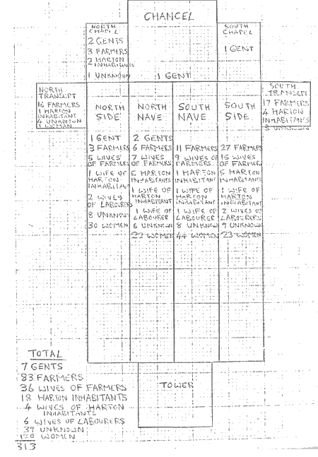
FIG 8: SEATING PLAN OF STOKE CHURCH IN 1613 ACCORDING TO OCCUPATIONS
The 1613 pew list shows the pre-eminent position of the local gentry [PAGE (48)] in the parish. Andrew Lutterell, Lord of Stoke Manor by 1609 [152], was in pride of place in the chancel, while his son Nicholas held all the pews in the South Chapel and two pews in the North Nave. Even the more junior members of the Lutterell family, apparently, were not short of seats. James Prust gent and John Velly gent were placed in the North Chapel while Thomas Docton esquire (see page 31) held the pew that headed the North Side, while his wife, Alice, sat just behind him. Thomas Docton also held two seats in the North Nave. William Hooper gent and Thomas Cholwill gent both sat in the pew that headed the North Nave.
The 1613 pew list shows that the Puritan idea of the family pew had not yet permeated as far as Hartland. The congregation was firmly divided into male and female groups - with a few exceptions - and wives were usually separated from their husbands.
Fig 8 shows the allocation of seats in the church according to the probable occupations of the congregation. Only 39 individuals could not be matched with any occupation, together with 120 of the women who were not linked with a husband of known occupation. The farming community certainly formed a large proportion of the congregation in 1613: altogether 119 individuals if one adds all farmers (83 men) to those farmers' wives whose husbands were not represented on the pew list. The proportion of Harton craftsmen and shopkeepers was considerably smaller (22 individuals: 18 craftsmen and shopkeepers and 4 wives).
In real terms, the number of people recorded on the pew list from even a priveleged section of the parish population such as the gentry and farmers was lower than the total number of these people recorded from other sources. This raises the question of whether Hartland church really was the sole place of worship for the parish by 1613. Families from the more remote corners of the parish may still have been attending their medieval chapels, or even crossing parish boundaries to attend a [PAGE (49)] different church. It would be reasonable to assume that the inhabitants of South Hole, for instance, preferred to travel the shorter distance to Welcombe church rather than the five miles to their parish church. These people probably saw Hartland church as their centre for important festivals, but not for regular Sunday worship. The former point is evident in the fact that people linked with South Hole as well as other outlying areas of the parish) were regularly baptised, married and buried at Hartland church, as is clear in the register [153].
Hartland church in 1613 could be divided into two areas: one area containing the 'prestigious' pews and the other containing the remaining pews in the west half of the church. The evidence shows that the section of the church comprising the Chancel, the two chapels, the two transepts and the front rows of the two Sides and two Naves should be envisaged as the 'prestigious' area of the church. Altogether, the pew list indicates that 7 gentry, 42 farmers, 7 craftsmen and shopkeepers, 9 men of unknown occupation and one woman sat in the 'prestigious' area of the church. The proportion of farmers to Harton craftsmen and shopkeepers was approximately the same (about six to one) in both the 'prestigious' area and in the whole church generally. It is clear that although the farming community considerably outnumbered the Borough inhabitants, a successful craftsman or shopkeeper could nevertheless expect to be allocated a 'prestigious' pew in the church alongside the gentry and the more prosperous yeomen.
The 1613 pew list also shows that office-holding in the parish was invariably a function of status. Hartland had an unusual form of church government at this time, consisting of 24 governors, 4 of whom were chosen every four years as an active executive body, one of these becoming Church Treasurer every year [154]. The 4 active governors [PAGE (50)] were responsible for the collection of church rates, and for church fabric, poor relief and the destruction of vermin [155]. There were also two Churchwardens who were appointed every year, and who were resonsible for lesser duties such as maintaining supplies of communion bread and wine and the washing of church linen [155]. This indicates that there were many church offices to be filled, although only lists of Church Treasurers and Churchwardens survive. On the other hand, the names of some of the church governors in 1613 can be taken from the list of men who appeared in the letter to the Archbishop of Canterbury written that year [156]. Together with Hugh Prust, who was Church Treasurer in 1613, this makes a group of at least 12 church governors. Seven of these men sat in the four pews that headed the two Naves and two Sides. Two other men sat in the North and South Transepts, while only one man sat in a pew in the 'non-prestigious' area of the church (in the second pew of the North Nave).
Fig 7 shows the location of the pews of 45 men who were Church Treasurers and Churchwardens between 1596 (when the lists of these officials commence) and 1620. This excludes a figure of 28 Church Treasurers and Churchwardens who could not be located on the pew list; they had possibly died by 1613. Altogether 35 out of 68 seats in the 'prestigious' area of the church were taken by known church officials while only 9 out of the 279 seats in the 'non-prestigious' area were occupied by these men.
The position of a seat in Hartland church in 1613 depended upon social status, economic success and the sex of the person in question. This last point should be emphasised as only one woman - Margaret Seccombe - was able to find a seat in the 'prestigious' area of the church. It may be remembered that the Seccombes were a parish gentry family mentioned in Chapter 3. Fig 7 also shows that only four men sat [PAGE (51)] in the area of the church west of the south porch (there were probably some men, however, who sat in the 'unnamed pews' at the west end of the North Side). There was also a tendency for women to sit on the north side of the church, while men who failed to find seats in the 'prestigious' area were generally seated on the south side as far west as the south porch. This perhaps reflects the old medieval belief that the north side of a churchyard was the evil side where only the poor were buried. It would be interesting to know whether this old superstition still affected the Protestant congregation of Hartland church to such an extent that it had an impact upon the new seating arrangements of 1613.
It is also evident that there were more women than men recorded on the pew list. Altogether, 189 women (133 of whom were called wives, 3 widows and 53 women with no defined attachment) appeared on the pew list in comparison with 131 men. Approximately half of the 133 wives on the pew list had husbands who were not mentioned on the document. This suggests that pews were considered to be so expensive to rent that only one seat was held by the poorer families, occupied in the wife's name. Six labourers' wives, for instance, held inferior seats at the west end of the church, while their husbands were not recorded.
In general terms, the pew list of 1613 gives an incomplete view of the social structure of Hartland parish. The gentry, farmers and the inhabitants of Harton Borough were well represented, but the poorer members of the parish (mainly labourers and fishermen) were absent from the pew list except for a few individuals. This would still be the case even if all the occupations of all of the 320 recorded individuals were known. The estimated population of the parish at this time was about 1,200 people [157], although a considerable proportion of that figure must have been children who were generally unrecorded on [PAGE (52)] the pew list. The figure of 450 males recorded in the Protestation Returns of 1641 [158] almost certainly includes most labourers and fishermen. About 750 individuals (the estimated parish population minus these 450 males) would mainly have been wives and children. However, it is difficult to compare the 1613 pew list with the above statistics as the former listed a considerable number of women. It should be remembered that only 131 males appeared on the pew list.
The main value of the pew list, however, lies in its representation of the balance of social power in Hartland parish. Gentry, farmers and the inhabitants of Harton Borough were well represented because renting a church pew was seen as a mark of social prestige and could only be done for a price. The more wealthy members of the parish made sure that they occupied a large proportion of the limited number of seats. The families of labourers and fishermen would have presumably had to stand when they attended church. Therefore, the pew list acts as an interesting model of the stratified social structure of the parish, illustrating that minorities among the rural and urban populations held almost complete social and economic power in the parish.
xxxxxxxxxxxxxxxxxxxx
There is not much to be found in modern Hartland that is a direct link with the period between 1558 and 1620. The moors, coastline and fields are probably little changed from their appearence in the sixteenth and seventeenth centuries, the massive earthbanks surrounding each field having defied most modern attempts to alter the landscape. However, a system of tarmac roads and lanes now cross the parish, connecting once isolated farmsteads with the rest of England. Harton Borough has also greatly changed, most of the houses being of a more modern period. The Saturday market and two annual fairs have long since [PAGE (53)] been abandoned, while the market hall was converted into an Anglican chapel during the nineteenth century. Only the town clock, mended by David Frye and John Hollowford in 1612 and 1619 [160], still continues to count time in the market place. Hartland Abbey, once the home of the Abbot and Lutterell families, was almost completely rebuilt during the eighteenth century. Portraits of two members of the Abbot family now gaze mournfully down at a modern sitting-room in the house. Hartland parish church in the hamlet of Stoke is the most obvious link between the modern day and the period between 1558 and 1620. Thomas Docton or Hugh Prust of Gorvin would easily recognise the pews that were installed during their lifetimes, or the rood-screen, font and painted wooden ceiling that they had inherited from previous centuries. The monuments of Abbots, Lutterells and Doctons still cover the floors and walls, while the graveyard is full of slate tomb-stones commemorating the descendants of many of the 300 presumed resident families mentioned on Table 1. It would therefore be fitting to finish this dissertation with an imagined reconstruction of a service in Hartland church on a normal Sunday morning in 1613. Mr Dove, the curate, would be in the chancel celebrating communion, while members of the Lutterell family would be sitting on their new elaborately-carved pews in the South Chapel. Thomas Abbot, representing a younger branch of the former residents of Hartland Abbey, would be sitting in the North Chapel, perhaps feeling slightly uncomfortable to be placed so near Richard Crang, one of the more prosperous shopkeepers from Harton Borough. William Blagdon, Portreeve of Harton in 1613, would be occupying a seat in Pew 3 on the south side of the nave, while Hugh Prust of Garvin, Church Treasurer for that year, would be sitting in a pew at the head of the South Side of the church. John Galsworthy , having just ridden over from his farm at Moor, would be occupying his pew in the North Transept, while Alice Docton would be sitting at the head of [PAGE (54)] the bevy of women who filled most of the pews on the North Side of the church. Two seats in Pew 5 on the north side of the nave would be occupied by 'John Bagelhole of Tree and his wife', almost certainly the owners of an inn in Harton and a rare example of a husband and wife sitting in the same pew. The aisles in the west end of the church would be filled by a great collection of poor families, one of them probably being that of Simon White, a labourer who was to be employed by the church for 4 days work during 1617. A seat in Pew 21 on the South Side was occupied by 'Simon Whites wife'. Nicholas Lutterell would have possibly looked down from his superior seat in the South Chapel and smiled with satisfaction at this expression of the social order of his home parish, each family firmly in its place according to its economic wealth and social status.
FOOTNOTES
[1] A. Macfarlane, Reconstructing Historical Communities, 1977, p. 24.
[2] Ibid., p.28.
[3] Ibid., p.32.
[4] Ibid., p.35.
[5] The borough was called Harton in seventeenth century records but is now usually known by the parish name of Hartland.
[6]: G. Finch, 'The Population of Hartland in the Sixteenth and Seventeenth Centuries', The Devon Historian 19, 1979, p.12.
[7]: J.I. Dredge and R.P. Chope, The Register of Baptisms, Marriages and Burial of the Parish of Hartland, 1930-34,
[8]: J. Youings, Devon Monastic Lands: Calendar of Particulars for Grants, 1955 p.74.
[9]: P.R.O., LR/2.191, folio 94.
[10]: Rev. T.H. Chope, A Short History of Hartland Parish, 1896, p. 19.
[11]: D.R.O., Z17/3/19.
[12]: W.B. Stephens, Sources for English Local History, 1973, p.110.
[13]: A.J. Howard and T.L. Stoate, The Devon Muster-Roll for 1569, 1977, p.IX.
[14]: Finch, Population of Hartland, loc. cit., p.13.
[15]: D.R.O., 1201 A/B1.
[16]: I.L. Gregory, Hartland Church Accounts 1597-1706, 1950.
[17]: R.P. Chope, Farthest from Railways, 1977 edn, p.4.
[18]: Ibid., p.4.
[19]: W.G. Hoskins, Devon, 1954, p.405.
[20]: Chope, Farthest from Railways, loc. cit., p.15.
[21]: Ibid., p.14.
[22]: Hoskins, Devon, loc. cit., p.405.
[23]: Ibid., p.512.
[24]: R.P. Chope, The Book of Hartland, 1940, p.54.
[25]: Chope, Farthest from Railways, loc. cit., p.14.
[26]: Chope, Book of Hartland, loc. cit., p.105.
[27]: D. Defoe, Tour through the Whole island of Great Britain, ed. G.D.H. Cole and D.C. Browning, 1928.
[28]: D.R.O., 1201/A/B1.
[29]: R. Carew, The Survey of Cornwall, 1769 edn, p.23.
[30]: D.R.O., Z17/3/19.
[31]: term meaning burning the grass cover and spreading the ashes as a fertilizer.
[32]: H.P.R. Finberg, Tavistock Abbey, 1951, pps 88-94.
[33]: I.L. Gregory, Hartland Church Accounts, 1950, p.28.
[34]: D.R.O., Z17/3/19.
[35]: Finberg, Tavistock, loc. cit., p. 104.
[36]: S. Colepresse, "A Georgicall [sic] Account of Devon and Cornwall," cited in Ibid., p.104.
[37]: D.R.O., Z 17/3/19.
[38]: R.P. Chope, 'The Early History of the Manor of Hartland', Transactions of the Devonshire Association, 1902, Vol. 24, Vol. XXXIV, p. 451.
[39]: J. Leland, Itinerary in England and Wales 1535-43, ed. L.T. Smith, 1964, Vol. 1., p.172.
[40]: Private collection in Hartland Abbey.
[41]: D.R.O., 1201/A/B1.
[42]: T. Westcote, View of Devonshire, ed. G. Oliver, 1845, p.61.
[43]: Gregory, Church Accounts, loc. cit., p.25
[44]: D.R.O., Z17 /3/19.
[45]: J.I. Dredge and R.P. Chope, Hartland Parish Register, 1930-34, pp 43, 214, 217-219.
[46]: J. Youings, Devon Monastic Lands: Calandar of Particulars for Grants, 1955, p . 74.
[47]: Gregory. Church Accounts, loc. cit., p.93.
[48]; J.J. Alexander & W.R. Hooper, History of Great Torrington, 1948, p.172.
[49]: Dredge & Chope, Hartland Register, loc. cit.
[50]: I.D. Thornley, 'Hartland Parish Records', Transactions of the Devon Association, 1930, Vol 62, pp 357-372.
[51]: 1613 Pew List: See Appendix.
[52]: Finberg, Tavistock, loc. cit., p.158.
[53]: D. Hey, An English Rural Community: Myddle under the Tudors and Stuarts, 1974, p.57.
[54]: W.G. Hoskins, Devon, 1954, p.512.
[55]: W.G. Maton, 'Observations of the Western Counties of England', Early Tours in Devon and Cornwall, R.P. Chope, 1961 edn, p.277.
[56]: Gregory, Church Accounts, loc. cit. pp. 82-83.
[57]: Appledore Maritime Museum, 'Sailing directions for the Channal Chart'.
[58]: D.R.O., 1201 A/B1
[59]: I.L. Gregory, Hartland Coast and Quay, 1949.
[60]: Westcote, View of Devonshire, loc. cit. p.67.
[61]: W.G. Hoskins, Devon, 1954, p.212.
[62]: W. Camden, Britannia, 1607 edn.
[63]: J.I. Dredge and R.P. Chope, The Register of Baptisms, Marriages and Burials of the Parish of Hartland, 1930-34.
[64]: L. Snell, The Suppression of the Religious Foundations of Devon and Cornwall, 1967, p.117.
[65]: R.P. Chope, Book of Hartland, 1940, p.106.
[66]: R.P. Chope, 'The Early History of the Manor of Hartland', Transactions of the Devonshire Association, 1902, Vol. 24, p.453.
[67]: Dredge & Chope, Hartland Register, loc. cit., p.X.
[68]: J.L. Vivian, Heralds Visitation of Devon, 1887.
[69]: JPs Notebook: see appendix.
[70]: A.J. Howard and T.L. Stoate, The Devon Muster-Roll for 1569, 1977.
[71]: Dredge & Chope, Hartland Register, loc. cit., p.X.
[72]: A. Macfarlane, Reconstructing Historical Communities, 1977, p.13.
[73]: D.R.O., ZI7/3/19.
[74]: By using the 1569 muster-roll and the Heralds' Visitations of Devon.
[75]: W.G. Hoskins, 'The Estates of the Caroline Gentry', Devonshire Studies, 1952, p. 335.
[76]: Ibid., p.358.
[77]: J.D. Chambers, Population, Economy and Society in Pre-Industrial England, 1972, p. 44.
[78]:W.G. Hoskins, Devon, 1954, p.172.
[79]: D. Hey. An English Rural community: Myddle under the Tudors and Stuarts, 1974, p.170.
[80]: Ibid., p.199.
[81]: G. Finch, 'The Population of Hartland in the Sixteenth and Seventeenth Centuries', The Devon Historian, 19, 1979, p.20.
[82]: Ibid., p. 21.
[83]: E.A. Wrigley, Population in History, 1969, p.71.
[84]: D.R.O., 1201/A/B1.
[85]: The plague recorded here may not necessarily have been bubonic plague but some other epidemic disease.
[86]: Finch, 'Population of Hartland; loc. cit., p.15.
[87]: R.P. Chope, The Book of Hartland, 1940, p.46.
[88]: D.R.O., Z17/3/19.
[89]: D.R.O., Z17/3/19.
[90]: Lists of Church Treasurers and Churchwardens in: J.I. Dredge and R.P. Chope, The Register of Baptisms, Marriages and Burials of the Parish of Hartland, 1930-34, pp XIII-XIV and 495.
[91]: I.L. Gregory, Hartland Church Accounts, 1950, p.8.
[92]: A.J.Howard and T.L.Stoate, The Devon Muster-Roll for 1569, 1977, p.138.
[93]: I.D. Thornley. 'Hartland Parish Records', Transactions of the Devonshire Association, Vol 62, 1930.
[94]: Dredge & Chope, Hartland Register, loc. cit. p.2.
[95]: See appendix.
[96]: Women on the 1613 Pew list were usually called by their Christian names and surnames.
[97]: Gregory, Church Accounts, loc. cit., p.67.
[98]: C. Worthy, Devonshire Wills, 1896, p.501.
[99]: See JPs Notebook in Appendix.
[100]: Dredge & Chope, Hartland Register, loc. cit, p.XIII.
[101]: Portreeve Accounts, D.R.O., 1201 A/B1.
[102]: R.P. Chope, Book of Hartland, 1940, p.106.
[103]: See the account of the Galsworthy family in: W.G.Hoskins and H.P. Fineberg, Devonshire Studies, 1952.
[104]: Ibid. p.103.
[105]: D.R.O., Z17/3/19.
[106]: Howard & Stoate, Muster-Roll, loc. cit, p.138.
[107]: Dredge & Chope, Parish Register, loc. cit, p.495.
[108]: D.R.O., 1201 A/B1.
[109]: D.R.O., Z17/3/19.
[110]: 1613 Pew List: see appendix.
[111]: D.R.O., Z17/3/19.
[112]: Dredge & Chope, Parish Register, loc. cit.
[113]: Portreeve Accounts, D.R.O., 1201 A/B1.
[114]: A. Everitt, 'Farm Labourers', The Agrarian History of England and Wales, Vol. 4, 1967, p.398.
[115]: J. Youings, Devon Monastic Lands: Calendar of Particulars for Grants, 1955, p. 74.
[116]: Dynham Survey, D.R.O., Z17/3/19.
[117]: Portreeve Accounts, D.R.O., 1201 A/B1.
[118]: I.L. Gregory, Hartland Church Accounts 1597-1706, 1950, p.67.
[119]: Gregory, Church Accounts, loc. cit., pp 2-47.
[120]: Ibid., p. 28.
[121]: Ibid., p.39.
[122]: Ibid., p.40.
[123]: Ibid., p. 70.
[124]: Ibid., pp 10-90.
[125]: Portreeve Accounts, D.R.O., 1201 A/B1.
[126]: I.D. Thornley, 'Hartland Parish Records', Transactions of the Devonshire Association, 1930, vol. 62.
[127]: Dredge & Chope, Hartland register, loc. cit.
[128]: Dynham Survey, D.R.O., Z17/3/19.
[129]: Portreeve Accounts, D.R.O., 1201 A/Bl.
[130]: Yeo was a fairly common name in the Hartland register.
[131]: J. Youings, Devon Monastic Lands: Calandar of Particulars for Grants, 1955, p.74.
[132]: J.I. Dredge and R.P. Chope, The Register of Baptisms, Marriages and Burials of the Parish of Hartland, 1930-34, p.131.
[133]: Portreeve Accounts, D.R.O., 1201 A/B1.
[134]: 1613 Pew List: See Appendix.
[135]: A. Everitt, 'Farm Labourers', The Agrarian History of England and Wales., Vol. 4, 1967, p.397.
[136]: Ibid., p.399.
[137]: G. Finch. 'The Population of Hartland in the Sixteenth and Seventeenth Centuries', The Devon Historian, 1979. Vol. 19, p.18.
[138]: Dredge & Chope, Hartland Register, loc. cit.
[139]: Everitt, 'Farm Labourer', loc. cit., p.435.
[140]: Dredge & Chope, Hartland Register, loc. cit.
[141]: Gregory, Church Accounts, loc. cit. p. 23.
[142]: Portreeve Accounts, D.R.O., 1201 A/B1.
[143]: Gregory, Church Accounts, loc. cit. p. 53.
[144]: Portreeve Accounts, D.R.O., 1201 A/B1.
[145]: Gregory, Church Accounts, loc. cit., p. 85.
[146]: I.D. Thornley, 'Hartland Parish Records', Transactions of the Devonshire Association, 1930. Vol. 62, pp357 - 372.
[147]: I.L. Gregory, Hartland Church Accounts, 1950, p.32.
[148]: Ibid., p.6.
[149]: C. Phythian-Adams, 'Ceremony and the Citizen: the Communal Year at Coventry.' The Early Modern Town. 1976, p.123.
[150]: R. Gough. History of Myddle, 1979, p.56.
[151]: R. Gough, Myddle, loc. cit., p.27
[152]: R.P. Chope, Book of Hartland, 1940, p.106.
[153]: J.I. Dredge and R.P. Chope, The Register of Baptisms, Marriages and Burials of the Parish of Hartland. 1930-34.
[154]: Ibid., p. XIII.
[155]: Dredge & Chope, Hartland Register, loc. cit., p.XIII.
[156]: Thornley, Parish Records, loc. cit., pp 357-372.
[157]: G. Finch, 'The Population of Hartland in the Sixteenth and Seventeenth Centuries', The Devon Historian, 19, 1979, p.21.
[158]: G. Finch, 'The Population of Hartland', loc. cit., p.13.
[160]: Portreeve Accounts, D.R.O., 1201 A/B1.