Hide
Sheldon
hide
Hide
hide
- Almanacs◬
- Archives & Libraries◬
- Bibliography◬
- Biography
- Business & Commerce Records◬
- Cemeteries◬
- Census◬
- Chronology◬
- Church History◬
- Church Records
- Churches
- Civil Registration◬
- Correctional Institutions◬
- Court Records◬
- Description & Travel
- Directories◬
- Emigration & Immigration◬
- Encyclopaedias & Dictionaries◬
- Folklore◬
- Gazetteers
- Genealogy
- Handwriting◬
- Heraldry◬
- Historical Geography◬
Hide
hide
- History
- Jewish History◬
- Land & Property◬
- Language & Languages◬
- Manors◬
- Maps
- Medical Records◬
- Merchant Marine◬
- Military History◬
- Names, Geographical◬
- Names, Personal◬
- Newspapers◬
- Occupations◬
- Periodicals◬
- Politics & Government◬
- Poor Houses, Poor Law◬
- Population◬
- Probate Records◬
- Schools◬
- Social Life & Customs◬
- Societies◬
- Taxation◬
- Voting Registers◬
Hide
"SHELDON, a small village and parish, picturesquely situated among the hills, about 6 miles E. by N. of Collumpton. and N.N.W. of Honiton, has only 190 souls, and 1300 acres of land, belonging to the Bank of Honiton; Mr. E. Doble, Mr. Henry Ellis, Mr. Geo. Speake, and a few smaller freeholders. The manor was held by Dunkeswell Abbey, and afterwards by the Bourchier and other families. The Church (St. James,) is a small antique fabric, with a tower and three bells, and the living is a perpetual curacy, valued in 1831 at £262, in the patronage of W. Miles, Esq., and incumbency of the Rev. Chas. E. Band, M.A., of Combe Rawleigh. There is no Parsonage House, and only half an acre of glebe, but the living is endowed with £140 a year out of the great tithes of Awliscombe parish. The tithes of Sheldon were commuted in 1837, for £145 per annum, and that portion which belonged to Dunkeswell Abbey is now vested in E.S. Drew, Esq. . . . " [From White's Devonshire Directory (1850)]
A parish in Hayridge Hundred, and the Archdeaconry and Diocese of Exeter.
Hide
Parish Registers going back to 1715 are held in the Devon Record Office.
The Devon FHS publishes indexes covering (as of June 2004): Baptisms 1813-1839, Marriages 1754-1837, Burials 1770-1837 - for details see their Devon Parish List.
Nothing entered into the IGI (as of Jan 1993).
Sparks, John, and Blackmore, Roy and Terrence. The A-Z of Births, Marriages and Burials for Sheldon, (2002). [Devon FHS Library p929.3/SHE]
The Deanery of Dunkeswell, CD012, Devon Family History Society, Exeter (2007). [Contains indexes: Awliscombe - Baptisms 1813-1839, Marriages 1754-1837, Burials 1813-1837; Churchstanton - Baptisms 1813-1837, Marriages 1754-1837, Burials 1813-1839; Clayhidon - Baptisms 1813-1839, Marriages 1754-1837, Burials 1813-1837; Combe Raleigh - Baptisms 1813-1839, Marriages 1754-1837, Burials 1813-1837; Dunkeswell - Baptisms 1813-1839, Marriages 1754-1837, Burials 1800-1837; Hemyock - Baptisms 1813-1839, Marriages 1635-1837, Burials 1813-1837; Luppitt - Baptisms 1813-1839, Marriages 1754-1838, Burials 1813-1837; Sheldon - Baptisms 1813-1839, Marriages 1755-1836, Burials 1770-1837; Upottery - Baptisms 1813-1839, Marriages 1754-1837, Burials 1813-1837; Yarcombe - Baptisms 1813-1839, Marriages 1754-1837, Burials 1813-1837.]
Section on Sheldon from Samuel Lewis: A Topographical Dictionary of England (1831), provided by Mel Lockie.
The transcription of the section for this parish from the National Gazetteer (1868), provided by Colin Hinson.
- Ask for a calculation of the distance from Sheldon to another place.
The Online Parish Clerk for this parish is Terry Blackmore, who invites queries and lookup requests.
The Blackmore's of Sheldon and Cullompton (archived copy), by Roy Blackmore.
Blackmore, Roy. Family Connections, Devon Family Historian, vol. 137, (2011) p.10. [Blackmore and Sparks families]
Sparks, John, and Blackmore, Roy. The Families of Sheldon [Sparks and Blackmores], (2002). [Devon FHS Library p929.2/SPA]
Sparks, Joseph Alfred A history of Sheldon, Devon. Typescript [1976] 40p: ill. [Westcountry Studies Library - sB/SHE 6/0001/SPA]
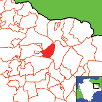
View a map of the boundaries of this town/parish.
You can see maps centred on OS grid reference ST120086 (Lat/Lon: 50.870179, -3.251971), Sheldon which are provided by:
- OpenStreetMap
- Google Maps
- StreetMap (Current Ordnance Survey maps)
- Bing (was Multimap)
- Old Maps Online
- National Library of Scotland (Old Ordnance Survey maps)
- Vision of Britain (Click "Historical units & statistics" for administrative areas.)
- English Jurisdictions in 1851 (Unfortunately the LDS have removed the facility to enable us to specify a starting location, you will need to search yourself on their map.)
- Magic (Geographic information) (Click + on map if it doesn't show)
- GeoHack (Links to on-line maps and location specific services.)
- All places within the same township/parish shown on an Openstreetmap map.
- Nearby townships/parishes shown on an Openstreetmap map.
- Nearby places shown on an Openstreetmap map.

