
Hide
Thelbridge
hide
Hide
hide
- Almanacs◬
- Archives & Libraries◬
- Bibliography◬
- Biography◬
- Business & Commerce Records◬
- Cemeteries
- Census
- Chronology◬
- Church History◬
- Church Records
- Churches
- Civil Registration◬
- Correctional Institutions◬
- Court Records◬
- Description & Travel
- Directories◬
- Emigration & Immigration◬
- Encyclopaedias & Dictionaries◬
- Folklore◬
- Gazetteers
- Genealogy
- Handwriting◬
- Heraldry◬
- Historical Geography◬
Hide
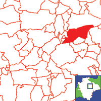
Click on map to view parish boundaries in detail.
Hide
Hide
hide
- History
- Jewish History◬
- Land & Property◬
- Language & Languages◬
- Manors◬
- Maps
- Medical Records◬
- Merchant Marine◬
- Military History
- Names, Geographical◬
- Names, Personal
- Newspapers◬
- Occupations
- Periodicals◬
- Politics & Government◬
- Poor Houses, Poor Law◬
- Population◬
- Probate Records
- Schools◬
- Social Life & Customs◬
- Societies◬
- Taxation◬
- Voting Registers◬
Hide
"THELBRIDGE is a parish and village on the road from Crediton to South Molton, 5 miles north-east from Lapford station on the North Devon branch of the London and South Western railway, 9 north-north-west from Crediton, 7 east-south-east from Chulmleigh and 15 north-west from Exeter, in the Northern division of the county, Witheridge hundred, South Molton petty sessional division, Crediton union and county court district, rural deanery of Chulmleigh, archdeaconry of Barnstaple and diocese of Exeter. The church of St. David is a small building of stone in the Early English style. . . . in the church is a tablet to the Rev. Robert Venn, sometime rector here, who died in 1689, and is mentioned in Fox's "Sufferings of the Clergy": the stained east window was presented by the parishioners in 1872, in which year the church was thoroughly restored at a cost of £650, and has 150 sittings. The register dates from about 1612. . . . The chief crops are wheat, barley and oats. The area is 4,006 acres; rateable value, £2,599; the population in 1901 was 319." [From: Kelly's Directory of Devonshire, 1902]
A parish in Witheridge Hundred, the Archdeaconry of Barnstaple, and the Diocese of Exeter.
Hide
MIs for this parish are included in the Incledon and NDA North Devon indexes - see under Cemeteries on the main Devon page.
Snetzler, M.F. North Devon Surname Index to the Census. Microfiche: M.F. Snetzler. [Covers 1881 census records for this parish]
Parish Registers going back to 1632 are held in the Devon Record Office.
Transcripts of the Parish Registers going back to 1633 are held in a special collection in the Westcountry Studies Library.
The Devon FHS publishes indexes covering (as of June 2004): Marriages 1754-1837, Burials 1813-1856 - for details see their Devon Parish List.
Entered into the IGI (as of Jan 1993): Parish Church Christenings 1633-1837 and Marriages 1635-1639, 1654-1837.
The Deanery of South Molton: An index of baptisms, marriages and burials in the parishes of Bishop's Nympton, Cheldon, Creacombe, Cruwys Morchard, East Anstey, East Woolfardisworthy, East Worlington, George Nympton, King's Nympton, Knowstone, Mariansleigh, Meshaw, Molland, North Molton, Oakford, Puddington, Rackenford, Romansleigh, Rose Ash, Satterleigh, South Molton, Stoodleigh, Templeton, Thelbridge, Twitchen, Warkleigh, Washford Pyne, West Anstey, West Worlington and Witheridge. With photographs of the churches and extracts from White's Directory (1850) and Kelly's Directory of Devonshire (1902). CD-ROM 062, Exeter, Devon FHS (2015). [Bishop's Nympton Bapt: 1813-1839, Mar: 1754-1837, Bur: 1813-1837; Cheldon Bapt: 1813-1843, Mar: 1755-1835, Bur: 1813-1841; Creacombe Bapt: 1814-1902, Mar: 1759-1835, Bur: 1813-1850; Cruwys Morchard Bapt: 1813-1840, Mar: 1754-1837, Bur: 1813-1837; East Anstey Bapt: 1813-1840, Mar: 1754-1836, Bur: 1688-1839; East Woolfardisworthy Bapt: 1813-1840, Mar: 1754-1840, Bur: 1813-1837; East Worlington Bapt: 1813-1840, Mar: 1754-1837, Bur: 1813-1837; George Nympton Bapt: 1813-1840, Mar: 1755-1837, Bur: 1790-1837; King's Nympton Bapt: 1813-1840, Mar: 1754-1837, Bur: 1813-1837; Knowstone Bapt: 1813-1840, Mar: 1740-1836, Bur: 1813-1837; Mariansleigh Bapt: 1813-1839, Mar: 1757-1837, Bur: 1813-1838; Meshaw Bapt: 1813-1839, Mar: 1756-1836, Bur: 1813-1838; Molland Bapt: 1813-1840, Mar: 1754-1837, Bur: 1813-1838; North Molton Bapt: 1813-1839, Mar: 1754-1837, Bur: 1813-1837; Oakford Bapt: 1813-1839, Mar: 1754-1837, Bur: 1813-1840; Puddington Bapt: 1813-1839, Mar: 1759-1836, Bur: 1740-1837; Rackenford Bapt: 1813-1840, Mar: 1754-1837, Bur: 1800-1837; Romansleigh Bapt: 1813-1839, Mar: 1754-1836, Bur: 1730-1837; Rose Ash Bapt: 1813-1839, Mar: 1754-1837, Bur: 1813-1850; Satterleigh Bapt: 1813-1839, Mar: 1755-1836, Bur: 1813-1837; South Molton Bapt: 1813-1840, Mar: 1754-1837, Bur: 1813-1837; Stoodleigh Bapt: 1813-1840, Mar: 1754-1837, Bur: 1813-1837; Templeton Bapt: 1813-1840, Mar: 1754-1837, Bur: 1813-1837; Thelbridge Bapt: 1813-1839, Mar: 1754-1837, Bur: 1813-1853; Twitchen Bapt: 1813-1839, Mar: 1755-1836, Bur: 1813-1837; Warkleigh Bapt: 1813-1839, Mar: 1754-1837, Bur: 1813-1851; Washford Pyne Bapt: 1813-1840, Mar: 1756-1836, Bur: 1813-1840; West Anstey Bapt: 1813-1840, Mar: 1754-1836, Bur: 1745-1838; West Worlington Bapt: 1813-1840, Mar: 1754-1846, Bur: 1813-1851; Witheridge Bapt: 1813-1839, Mar: 1754-1837, Bur: 1813-1835]
Section on Thelbridge from Samuel Lewis: A Topographical Dictionary of England (1831), provided by Mel Lockie.
The transcription of the section for this parish from the National Gazetteer (1868), provided by Colin Hinson.
- Ask for a calculation of the distance from Thelbridge to another place.
The Online Parish Clerk scheme's representative for this parish is Rob Adams, who invites queries and lookup requests.
Somerwill - a Devon Family, by John S. Summerwill.
Leach, Margaret. John Greenslade, Devon Family Historian, vol. 123, (2007) pp.7-8. [b. Thelbridge 1846, emigrated to Canada 1888]
View a map of the boundaries of this town/parish.
You can see maps centred on OS grid reference SS787121 (Lat/Lon: 50.895603, -3.726174), Thelbridge which are provided by:
- OpenStreetMap
- Google Maps
- StreetMap (Current Ordnance Survey maps)
- Bing (was Multimap)
- Old Maps Online
- National Library of Scotland (Old Ordnance Survey maps)
- Vision of Britain (Click "Historical units & statistics" for administrative areas.)
- English Jurisdictions in 1851 (Unfortunately the LDS have removed the facility to enable us to specify a starting location, you will need to search yourself on their map.)
- Magic (Geographic information) (Click + on map if it doesn't show)
- GeoHack (Links to on-line maps and location specific services.)
- All places within the same township/parish shown on an Openstreetmap map.
- Nearby townships/parishes shown on an Openstreetmap map.
- Nearby places shown on an Openstreetmap map.
Details from the War Memorial, provided by Emily Hollins.
Thelbridge contributors to a 1678 brief for the rebuilding of St Paul's Cathedral.
Thelbridge Apprentice Register 1804-1828. [Devon]: Devon Family History Society (2013). [Foreword]
Transcript of the will of George Elworthye (1597) provided by Ros Dunning.
Transcript of the will of George Elworthy (1623) provided by Christine Gibbins.