
Hide
Alkrington
hide
Hide
hide
Hide
hide
Hide
Hide
ALKRINGTON, a township in Prestwick-cum-Oldham parish, Lancashire; 1 mile W of Middleton Junction r. station, and 4½. N by E of Manchester. Acres, 788. Real property, £1,957. Pop., 423. Houses, 77. The inhabitants are employed chiefly in the neighbouring cotton factories. Alkrington Hall is the seat of the Lever family, and is noted for Sir Aston Lever's collecting a museum at it, which was sold in London.
John Marius Wilson, Imperial Gazetteer of England and Wales (1870-72)
Hide
Local studies information is held at Middleton library.
Details about the census records, and indexes for Alkrington.
| Manchester New Road Congregational, Alkrington |
| St Thomas More, Alkrington, Roman Catholic |
The Register Office covering the Alkrington area is Oldham.
The National Gazetteer of Great Britain and Ireland - 1868
"ALKRINGTON, a township in the parish of Prestwich, hundred of Salford, in the county palatine of Lancaster, 1 mile to the S. of Middleton. The small river Irk flows through the township. The cotton manufacture affords the principal employment of the inhabitants. Alkrington Hall was once the seat of Sir Aston Lever, whose well-known museum was formed here."
- Ask for a calculation of the distance from Alkrington to another place.
In 1835 Alkrington was a township in the parish of Oldham.
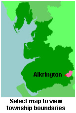
View a map of the boundaries of this town/parish.
You can see maps centred on OS grid reference SD872046 (Lat/Lon: 53.53819, -2.194702), Alkrington which are provided by:
- OpenStreetMap
- Google Maps
- StreetMap (Current Ordnance Survey maps)
- Bing (was Multimap)
- Old Maps Online
- National Library of Scotland (Old Ordnance Survey maps)
- Vision of Britain (Click "Historical units & statistics" for administrative areas.)
- English Jurisdictions in 1851 (Unfortunately the LDS have removed the facility to enable us to specify a starting location, you will need to search yourself on their map.)
- Magic (Geographic information) (Click + on map if it doesn't show)
- GeoHack (Links to on-line maps and location specific services.)
- All places within the same township/parish shown on an Openstreetmap map.
- Nearby townships/parishes shown on an Openstreetmap map.
- Nearby places shown on an Openstreetmap map.
For probate purposes prior to 1858, Alkrington was in the Archdeaconry of Chester, in the Diocese of Chester. The original Lancashire wills for the Archdeaconry of Chester are held at the Lancashire Record Office.
You can also see Family History Societies covering the nearby area, plotted on a map. This facility is being developed, and is awaiting societies to enter information about the places they cover.