
Hide
Ancoats & Collyhurst
hide
Hide
hide
Hide
hide
Hide
Hide
"ANCOATS, a chapelry in the parish of Manchester and suburbs of Manchester, in the hundred of Salford, in the county palatine of Lancaster. There are two curacies in this district both in the diocese of Manchester, and in the patronage of the dean and chapter. The churches are dedicated to St. Andrew and All Souls. The living of the former is valued at £124, and that of the latter at £174. Ancoats Hall, which is a timbered mansion, was formerly the seat of the Moseleys, to whom the manor of Manchester belonged."
from The National Gazetteer of Great Britain and Ireland 1868
Hide
Local studies information is held at Manchester central library.
Details about the census records, and indexes for Ancoats.
The Register Office covering the Ancoats area is Manchester.
Old pictures of Ancoats.
The National Gazetteer of Great Britain and Ireland - 1868
"ANCOATS, a chapelry in the parish of Manchester and suburbs of Manchester, in the hundred of Salford, in the county palatine of Lancaster. There are two curacies in this district both in the diocese of Manchester, and in the patronage of the dean and chapter. The churches are dedicated to St. Andrew and All Souls. The living of the former is valued at £124, and that of the latter at £174. Ancoats Hall, which is a timbered mansion, was formerly the seat of the Moseleys, to whom the manor of Manchester belonged."
- Ask for a calculation of the distance from Ancoats & Collyhurst to another place.
In Ancoats was a locality in Manchester township.
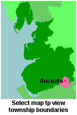
View maps of Ancoats and places within its boundaries.
View a map of the boundaries of this town/parish.
You can see maps centred on OS grid reference SJ855996 (Lat/Lon: 53.492473, -2.219839), Ancoats & Collyhurst which are provided by:
- OpenStreetMap
- Google Maps
- StreetMap (Current Ordnance Survey maps)
- Bing (was Multimap)
- Old Maps Online
- National Library of Scotland (Old Ordnance Survey maps)
- Vision of Britain (Click "Historical units & statistics" for administrative areas.)
- English Jurisdictions in 1851 (Unfortunately the LDS have removed the facility to enable us to specify a starting location, you will need to search yourself on their map.)
- Magic (Geographic information) (Click + on map if it doesn't show)
- GeoHack (Links to on-line maps and location specific services.)
- All places within the same township/parish shown on an Openstreetmap map.
- Nearby townships/parishes shown on an Openstreetmap map.
- Nearby places shown on an Openstreetmap map.
For probate purposes prior to 1858, Ancoats was in the Archdeaconry of Chester, in the Diocese of Chester. The original Lancashire wills for the Archdeaconry of Chester are held at the Lancashire Record Office.
You can also see Family History Societies covering the nearby area, plotted on a map. This facility is being developed, and is awaiting societies to enter information about the places they cover.