
Hide
Angerton
hide
Hide
hide
Hide
hide
Hide
Hide
Angerton.-- par., Ulverston registration dist., Lancashire, 2195 ac. (1121 water), pop. 32.
John Bartholomew, Gazetteer of the British Isles (1887)
Hide
Local studies information is held at Cumbria Record Office & Local Studies Library, Barrow.
Details about the census records, and indexes for Angerton.
The Register Office covering the Angerton area is Ulverston.
The National Gazetteer of Great Britain and Ireland - 1868
"WAITHAM HILL, an extra parochial place in the hundred of Lonsdale North of the Sands, county Lancaster, 4 miles N.W. of Ulverston. It includes the hamlets of Mosshouses, Marsfield, and Headhouse."
- Ask for a calculation of the distance from Angerton to another place.
In 1835 Angerton (or Mosshouses and Waitham Hill) was a township in the parish of Kirkby Ireleth.
View maps of Angerton and places within its boundaries.
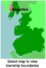
View a map of the boundaries of this town/parish.
You can see maps centred on OS grid reference SD212824 (Lat/Lon: 54.231223, -3.209757), Angerton which are provided by:
- OpenStreetMap
- Google Maps
- StreetMap (Current Ordnance Survey maps)
- Bing (was Multimap)
- Old Maps Online
- National Library of Scotland (Old Ordnance Survey maps)
- Vision of Britain (Click "Historical units & statistics" for administrative areas.)
- English Jurisdictions in 1851 (Unfortunately the LDS have removed the facility to enable us to specify a starting location, you will need to search yourself on their map.)
- Magic (Geographic information) (Click + on map if it doesn't show)
- GeoHack (Links to on-line maps and location specific services.)
- All places within the same township/parish shown on an Openstreetmap map.
- Nearby townships/parishes shown on an Openstreetmap map.
- Nearby places shown on an Openstreetmap map.
For probate purposes prior to 1858, Angerton was in the peculiar of the Dean of the Chapter of York whose records are deposited at the Borthwick Institute.
You can also see Family History Societies covering the nearby area, plotted on a map. This facility is being developed, and is awaiting societies to enter information about the places they cover.