
Hide
Ardwick
hide
Hide
hide
Hide
hide
Hide
Hide
ARDWICK, a township, three chapelries, and a subdistrict in Manchester parish, Lancashire. The township is suburban to Manchester city, on the SE; and lies within the borough boundaries. Acres, 470. Real property, £57,895. Pop., 21,757. Houses, 4,414. The Manchester and Sheffield railway has a station here, ¾ of a mile from the terminus; joins here the Manchester and Birmingham railway near Chancery lane; and is carried here on a succession of immense viaducts. The chapelries are Ardwick - St. Thomas, Ardwick St. Silas, and Ardwick St. Matthew; and were constituted in respectively 1838, 1844, and 1868. Pop. of A. St. T., 10,147. Houses, 2,029. Pop. of A. St. S., 10,375. Houses, 2,143. The livings are rectories in the diocese of Manchester. Value of St. E. and St. S., each £300; of St. M., not reported. Patrons of St. T., the Dean and Chapter of Manchester, of St. S. and St. M., Trustees. The subdistrict includes also four other townships, and is in Chorlton district. Acres, 4,031. Pop., 47,752. Houses, 9,322.
John Marius Wilson, Imperial Gazetteer of England and Wales (1870-72)
Hide
Local studies information is held at Manchester central library.
| Ardwick Cemetery |
Details about the census records, and indexes for Ardwick.
| Emmanuel, Ardwick, Baptist |
| Indigo St, Pin Mill Brow, Ardwick, Independent |
| Tipping St, Ardwick, Congregational |
| Ardwick Cemetery |
| Union Street, Ardwick, Presbyterian |
| St Aloysius Roman Catholic, Ardwick |
The Register Office covering the Ardwick area is Manchester.
The National Gazetteer of Great Britain and Ireland - 1868
"ARDWICK, a chapelry in the parish of Manchester, in the county palatine of Lancaster, forming a constituent part of the town of Manchester. Ardwick station is the point at which the two great lines of railway, the Manchester and Birmingham, and the Manchester Sheffield, and Lincolnshire, unite. The river Medlock passes through the chapelry. Ardwick Green, which is about 2 miles from the Exchange, forms a pleasant approach to the town of Manchester. It is a kind of square, with an ornamental piece of water, lawns, shrubs, and walks. The living is a perpetual curacy in the diocese of Manchester, value £294, in the patronage of the Warden and Fellows of the Collegiate Church of Manchester. The church is dedicated to St. Thomas. The cotton manufacture, and other departments of the general Manchester trade, form the staple occupation."
- Ask for a calculation of the distance from Ardwick to another place.
In 1835 Ardwick was a township in the parish of Manchester.
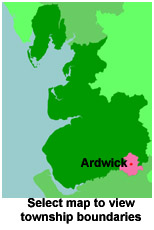
View maps of Ardwick and places within its boundaries.
View a map of the boundaries of this town/parish.
You can see maps centred on OS grid reference SJ860973 (Lat/Lon: 53.472367, -2.212125), Ardwick which are provided by:
- OpenStreetMap
- Google Maps
- StreetMap (Current Ordnance Survey maps)
- Bing (was Multimap)
- Old Maps Online
- National Library of Scotland (Old Ordnance Survey maps)
- Vision of Britain (Click "Historical units & statistics" for administrative areas.)
- English Jurisdictions in 1851 (Unfortunately the LDS have removed the facility to enable us to specify a starting location, you will need to search yourself on their map.)
- Magic (Geographic information) (Click + on map if it doesn't show)
- GeoHack (Links to on-line maps and location specific services.)
- All places within the same township/parish shown on an Openstreetmap map.
- Nearby townships/parishes shown on an Openstreetmap map.
- Nearby places shown on an Openstreetmap map.
For probate purposes prior to 1858, Ardwick was in the Archdeaconry of Chester, in the Diocese of Chester. The original Lancashire wills for the Archdeaconry of Chester are held at the Lancashire Record Office.
You can also see Family History Societies covering the nearby area, plotted on a map. This facility is being developed, and is awaiting societies to enter information about the places they cover.