
Hide
Bispham
hide
Hide
This is the Bispham in the parish of Croston. There is another Bispham north of Blackpool.
Hide
hide
Hide
hide
Hide
Hide
BISPHAM, a township in Croston parish, Lancashire; near the river Douglas, 2 miles E of Rufford r. station, and 6 NE of Ormskirk. Acres, 926. Real property, £1,740. Pop., 277. Houses, 48. A free grammar school here, founded in 1692, has an income of £162.
John Marius Wilson, Imperial Gazetteer of England and Wales (1870-72)
Hide
Local studies information is held at Ormskirk and Skelmersdale libraries.
Details about the census records, and indexes for Bispham.
The Register Office covering the Bispham area is West Lancashire.
The National Gazetteer of Great Britain and Ireland - 1868
"BISPHAM, a township in the parish of Croston, hundred of Leyland, in the county palatine of Lancaster, 6 miles to the W. of Chorley. The river Douglas runs through it. There is a free grammar school, established and endowed by Richard Darning in 1675, the revenue of which amounts to £160 per annum."
"LEYTON, a township in the parish of Bispham, hundred of Amounderness, county Lancaster, 2 miles S.W. of Poulton-le-Fylde. It is situated near the coast, and contains the village of Blackpool, which is resorted to in the summer as a bathing place."
"NORBRECK, a township in the parish of Bispham, hundred of Amounderness, county Lancaster, 3 miles N.W. of Poulton-le-Fylde. It is joined with Bispham to form a township."
"WARBRICK, a township in the parish of Bispham, hundred of Amounderness, county Lancaster, 2½ miles S.W. of Poulton-le-Fylde. It is situated on the coast, and includes the village of Blackpool. It is joined with Layton."
- Ask for a calculation of the distance from Bispham to another place.
In 1835 Bispham was a township in the parish of Croston.
View maps of Bispham Green and places within its boundaries.
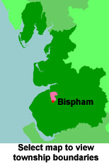
View a map of the boundaries of this town/parish.
You can see maps centred on OS grid reference SD487132 (Lat/Lon: 53.61243, -2.777433), Bispham which are provided by:
- OpenStreetMap
- Google Maps
- StreetMap (Current Ordnance Survey maps)
- Bing (was Multimap)
- Old Maps Online
- National Library of Scotland (Old Ordnance Survey maps)
- Vision of Britain (Click "Historical units & statistics" for administrative areas.)
- English Jurisdictions in 1851 (Unfortunately the LDS have removed the facility to enable us to specify a starting location, you will need to search yourself on their map.)
- Magic (Geographic information) (Click + on map if it doesn't show)
- GeoHack (Links to on-line maps and location specific services.)
- All places within the same township/parish shown on an Openstreetmap map.
- Nearby townships/parishes shown on an Openstreetmap map.
- Nearby places shown on an Openstreetmap map.
For probate purposes prior to 1858, Bispham was in the Archdeaconry of Chester, in the Diocese of Chester. The original Lancashire wills for the Archdeaconry of Chester are held at the Lancashire Record Office.
You can also see Family History Societies covering the nearby area, plotted on a map. This facility is being developed, and is awaiting societies to enter information about the places they cover.