
Hide
Castleton
hide
Hide
hide
Hide
hide
Hide
Hide
CASTLETON, a township and two subdistricts in Rochdale parish and district, Lancashire. The township stands on the Rochdale canal and the Manchester and Leeds railway, partly within the borough of Rochdale, partly in the south-eastern suburbs and environs. Real property, £102,077: of which £24,424 are in the canal. Pop. in 1841, 14,279; in 1861, 23,771. Houses, 4,884. The part without the borough includes the villages and hamlets of Buersill, Lowerplace, Newbold, Marland, Lower-Lane, Broad-Lane, Backlanes, Roeacre, Captainfold, Castleton-Moor, and Bluepits. There are traces of a castle, supposed to have been built before the Conquest. The subdistricts are C.-Within and C.-Without; and are jointly conterminate with the township. Pop. of C.Within, 13,971. Houses, 2,892.
John Marius Wilson, Imperial Gazetteer of England and Wales (1870-72)
Hide
Local studies information is held at Rochdale library.
Details about the census records, and indexes for Castleton.
| Heywood Rd Independent, Castleton |
| Heywood Rd, Castleton, United Methodist Free Church |
| Manchester Rd Wesleyan Methodist, Castleton |
The Register Office covering the Castleton area is Rochdale.
The National Gazetteer of Great Britain and Ireland - 1868
"CASTLETON, a township in the parish of Rochdale, hundred of Salford; in the county palatine of Lancaster, 1 mile from Rochdale. It forms part of the south-eastern suburbs, and includes the hamlets of Buersill and Marland., Here was formerly a castle of very ancient date, some vestiges of which still remain. The gas and water-works are situated in this township. The Rochdale canal passes near Castleton. The inhabitants are chiefly employed in the cotton and woollen manufactories."
"BUERSILL, a hamlet in the township of Castleton, and parish of Rochdale, hundred of Salford, in the county palatine of Lancaster, 2 miles from Rochdale. It is near the Rochdale canal."
- Ask for a calculation of the distance from Castleton to another place.
In 1835 Castleton was a township in the parish of Rochdale.
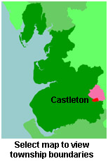
View maps of Castleton and places within its boundaries.
View a map of the boundaries of this town/parish.
You can see maps centred on OS grid reference SD891118 (Lat/Lon: 53.602726, -2.166688), Castleton which are provided by:
- OpenStreetMap
- Google Maps
- StreetMap (Current Ordnance Survey maps)
- Bing (was Multimap)
- Old Maps Online
- National Library of Scotland (Old Ordnance Survey maps)
- Vision of Britain (Click "Historical units & statistics" for administrative areas.)
- English Jurisdictions in 1851 (Unfortunately the LDS have removed the facility to enable us to specify a starting location, you will need to search yourself on their map.)
- Magic (Geographic information) (Click + on map if it doesn't show)
- GeoHack (Links to on-line maps and location specific services.)
- All places within the same township/parish shown on an Openstreetmap map.
- Nearby townships/parishes shown on an Openstreetmap map.
- Nearby places shown on an Openstreetmap map.
For probate purposes prior to 1858, Castleton was in the Archdeaconry of Chester, in the Diocese of Chester. The original Lancashire wills for the Archdeaconry of Chester are held at the Lancashire Record Office.
You can also see Family History Societies covering the nearby area, plotted on a map. This facility is being developed, and is awaiting societies to enter information about the places they cover.