
Hide
Croft with Southworth
hide
Hide
hide
Hide
hide
Hide
Hide
"SOUTHWORTH-WITH-CROFT, a parish in Warington district, Lancashire; 1¾ mile SSW of Kenyon-Junction r. station, and 4¼ NE by N of Warrington. It has a post-office, of the name of Croft, under Warrington. Acres, 1,851. Real property, £4,255. Pop., 1,094. Houses, 228. The property is much subdivided. The living is a rectory in the diocese of Chester. Value, £230.* Patron, the Earl of Derby. The church is recent, and has a spire. There are chapels for Independent Methodists and Roman Catholics, and an endowed school."
John Marius Wilson, Imperial Gazetteer of England and Wales (1870-72)
Hide
| New Lane Unitarian, Croft |
| St Lewis Roman Catholic, Croft |
Details about the census records, and indexes for Croft with Southworth.
| New Lane Unitarian, Croft |
| St Lewis Roman Catholic, Croft |
The Register Office covering the Croft area is Warrington.
The National Gazetteer of Great Britain and Ireland - 1868
"CROFT, a hamlet in the parish of Winwick, hundred of West Derby, in the county of Lancaster, 3 miles S.E, of Newton, and 4 N. of Warrington. Joined with Southworth, it forms a township The living is a rectory in the diocese of Chester, in the patronage of the rector. The church, dedicated to Christ, is a new structure built in 1833, in the Gothic style. The Independents, Methodists, and Roman Catholics have each a chapel. There is an endowed school, also a Sunday-school."
"SOUTHWORTH-WITH-CROFT, a township in the parish of Winwick, hundred of West Derby, county Lancaster, 3 miles S.E. of Newton-in-Mackerfield. The village is considerable."
- Ask for a calculation of the distance from Croft with Southworth to another place.
In 1835 Southworth with Croft was a township in the parish of Winwick.
View maps of Croft and places within its boundaries.
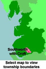
View a map of the boundaries of this town/parish.
You can see maps centred on OS grid reference SJ626933 (Lat/Lon: 53.435169, -2.565098), Croft with Southworth which are provided by:
- OpenStreetMap
- Google Maps
- StreetMap (Current Ordnance Survey maps)
- Bing (was Multimap)
- Old Maps Online
- National Library of Scotland (Old Ordnance Survey maps)
- Vision of Britain (Click "Historical units & statistics" for administrative areas.)
- English Jurisdictions in 1851 (Unfortunately the LDS have removed the facility to enable us to specify a starting location, you will need to search yourself on their map.)
- Magic (Geographic information) (Click + on map if it doesn't show)
- GeoHack (Links to on-line maps and location specific services.)
- All places within the same township/parish shown on an Openstreetmap map.
- Nearby townships/parishes shown on an Openstreetmap map.
- Nearby places shown on an Openstreetmap map.
For probate purposes prior to 1858, Croft was in the Archdeaconry of Chester, in the Diocese of Chester. The original Lancashire wills for the Archdeaconry of Chester are held at the Lancashire Record Office.
You can also see Family History Societies covering the nearby area, plotted on a map. This facility is being developed, and is awaiting societies to enter information about the places they cover.