
Hide
Crosby
hide
Hide
hide
Hide
hide
Hide
Hide
CROSBY (Great), a village and a chapelry in Sephton parish, Lancashire. The village stands on the coast, near the river Mersey's mouth, 1¾ mile W of the Liverpool and Southport railway, 6½ miles NNW of Liverpool; is a much-frequented watering place; and has a station on the railway, a post office under Liverpool, and two hotels. The chapelry comprises 5,627 acres; of which 3,510 are water. Real property, £22,495. Pop., 3,794. Houses, 686. The property is much subdivided. Crosby House is the seat of John Myers, Esq. Crosby Point is near the village; Crosby lighthouse, 1¼ mile N of the Point, was erected in 1839, and shows a fixed light, 81 feet high; Crosby floating light is moored at the east elbow of the Burbo bank; and Crosby Channel, between that bank and the Formby, and about 6½ miles long, is the main entrance to. the Mersey. The living is a p. curacy in the diocese of Chester. Value, £119.* Patron, the Rector of Sephton. The church was built in 1854, is cruciform and handsome, and has a tower with lofty spire. There are an elegant Wesleyan chapel, built in 1863 at a cost of £5,000, a Roman Catholic chapel, an endowed grammar school, an endowed girls' school, and a Roman Catholic convent school.
John Marius Wilson, Imperial Gazetteer of England and Wales (1870-72)
Hide
Local studies information is held at Crosby library.
| St Luke, Crosby, Church of England |
Details about the census records, and indexes for Crosby.
| St Luke, Crosby, Church of England |
| Mersey Rd, Crosby, Congregational |
The burials at SS Peter and Paul RC Church have been made available by the Anglo-Irish FHS.
The Register Office covering the Crosby area is Sefton South.
- Ask for a calculation of the distance from Crosby to another place.
In 1835 Crosby was a chapelry in the township of Great Crosby, in the parish of Sefton.
View maps of Crosby and places within its boundaries.
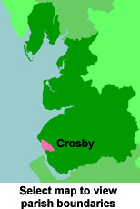
View a map of the boundaries of this town/parish.
You can see maps centred on OS grid reference SD311007 (Lat/Lon: 53.498108, -3.040316), Crosby which are provided by:
- OpenStreetMap
- Google Maps
- StreetMap (Current Ordnance Survey maps)
- Bing (was Multimap)
- Old Maps Online
- National Library of Scotland (Old Ordnance Survey maps)
- Vision of Britain (Click "Historical units & statistics" for administrative areas.)
- English Jurisdictions in 1851 (Unfortunately the LDS have removed the facility to enable us to specify a starting location, you will need to search yourself on their map.)
- Magic (Geographic information) (Click + on map if it doesn't show)
- GeoHack (Links to on-line maps and location specific services.)
- All places within the same township/parish shown on an Openstreetmap map.
- Nearby townships/parishes shown on an Openstreetmap map.
- Nearby places shown on an Openstreetmap map.
For probate purposes prior to 1858, Crosby was in the Archdeaconry of Chester, in the Diocese of Chester. The original Lancashire wills for the Archdeaconry of Chester are held at the Lancashire Record Office.
You can also see Family History Societies covering the nearby area, plotted on a map. This facility is being developed, and is awaiting societies to enter information about the places they cover.