
Hide
Farington
hide
Hide
hide
Hide
hide
Hide
Hide
FARRINGTON, a township and a chapelry in Penwortham parish, Lancashire. The township lies on the river Lostock, and on the Preston and Wigan railway, 4 miles S of Preston; and has a station on the railway, and a post office under Preston. Acres, 1,786. Real property, £7,174. Pop., 1,791. Houses, 311. The property is divided among a few. Farrington House and Farrington Lodge are chief residences. Part of the land is marshy. Many of the inhabitants are employed in cotton mills. The chapelry is more extensive than the township; and was constituted in 1843. Pop., 2,292. Houses, 407. The living is a p. curacy in the diocese of Manchester. Value, £120. Patron, the Incumbent of Penwortham. The church is modern. There is a free school.
John Marius Wilson, Imperial Gazetteer of England and Wales (1870-72)
Hide
Local studies information is held at Leyland library.
| St Paul Church of England, Farington |
Details about the census records, and indexes for Farington.
| St Paul Church of England, Farington |
| St Catherine Laboure, Farington, Roman Catholic |
The Register Office covering the Farington area is Preston and South Ribble
The National Gazetteer of Great Britain and Ireland - 1868
"FARRINGTON, a township in the parish of Penwortham, hundred of Leyland, county palatine Lancaster, 3 miles S. of Preston, its post town, and 62 N.W. of Chorley. It is situated on the river Lostock, and is a station on the London and North-Western railway. Cotton-spinning gives employment to the greater part of the inhabitants. The tithes were commuted for land and a money payment under the Enclosure Act in 1819. The living is a perpetual curacy in the diocese of Manchester, value £120, in the gift of the Incumbent of Penwortham. The church is a modern structure dedicated to St. Paul. Here is an endowed free school, a factory school, and Sunday-schools. Farrington House and Farrington Lodge are the principal residences. Lawrence Rawstorne, Esq., is lord of the manor."
- Ask for a calculation of the distance from Farington to another place.
In 1835 Farington was a township in the parish of Penwortham.
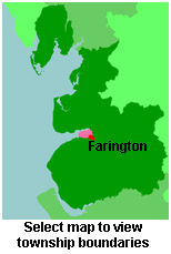
View a map of the boundaries of this town/parish.
You can see maps centred on OS grid reference SD535243 (Lat/Lon: 53.713388, -2.706215), Farington which are provided by:
- OpenStreetMap
- Google Maps
- StreetMap (Current Ordnance Survey maps)
- Bing (was Multimap)
- Old Maps Online
- National Library of Scotland (Old Ordnance Survey maps)
- Vision of Britain (Click "Historical units & statistics" for administrative areas.)
- English Jurisdictions in 1851 (Unfortunately the LDS have removed the facility to enable us to specify a starting location, you will need to search yourself on their map.)
- Magic (Geographic information) (Click + on map if it doesn't show)
- GeoHack (Links to on-line maps and location specific services.)
- All places within the same township/parish shown on an Openstreetmap map.
- Nearby townships/parishes shown on an Openstreetmap map.
- Nearby places shown on an Openstreetmap map.
For probate purposes prior to 1858, Farington was in the Archdeaconry of Chester, in the Diocese of Chester. The original Lancashire wills for the Archdeaconry of Chester are held at the Lancashire Record Office.
You can also see Family History Societies covering the nearby area, plotted on a map. This facility is being developed, and is awaiting societies to enter information about the places they cover.