
Hide
Flixton
hide
Hide
hide
Hide
hide
Hide
Hide
FLIXTON, a township and a parish in Barton-upon-Irwell district, Lancashire. The township lies in the peninsula between the rivers Irwell and Mersey, 3½ miles SSE of Barton-Moss r. station, and 7 WSW of Manchester; and has a post office under Manchester. Acres, 1,575. Real property, £6,966. Pop., 1,302. Houses, 251. The parish includes also the township of Urmston. Acres, 2,549. Real property, £11,477. Pop., 2,050. Houses, 409. The property is subdivided. Flixton Hall is the seat of the Wright family. The living is a rectory in the diocese of Manchester. Value, £300.* Patron, the Bishop of Manchester. The church is good; and there were placed in it, in 1859, two memorial windows of Mr Thomas Rogers and of the Wright family. The vicarage of Urmston is a separate charge, constituted in 1868. There are two Wesleyan chapels, and charities £11.
John Marius Wilson, Imperial Gazetteer of England and Wales (1870-72)
Hide
Local studies information is held at Trafford Local studies library.
Details about the census records, and indexes for Flixton.
The Register Office covering the Flixton area is Trafford.
The National Gazetteer of Great Britain and Ireland - 1868
"FLIXTON, a parish in the hundred of Salford, county palatine Lancaster, 7 miles S.W. of Manchester, its post town. It is bounded on the N. and W. by the river Irwell, and S. by the Mersey, and includes the hamlet of Urmston. The surface is generally level, and the soil in some parts inclines to a peaty moss. Clover is extensively cultivated. The village is considerable, and contains some good residences of the Manchester merchants. The living is a perpetual curacy in the diocese of Manchester, value £150, in the patronage of the bishop. The church is dedicated to St. Michael. The Wesleyans have a chapel here. There is a school with an endowment of £10 per annum."
- Ask for a calculation of the distance from Flixton to another place.
In 1835 the parish of Flixton contained the townships of Flixton and Urmston. Information about boundaries and administrative areas is available from A Vision of Britain through time.
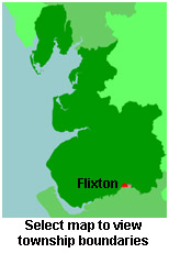
View a map of the boundaries of this town/parish.
You can see maps centred on OS grid reference SJ743945 (Lat/Lon: 53.446555, -2.38767), Flixton which are provided by:
- OpenStreetMap
- Google Maps
- StreetMap (Current Ordnance Survey maps)
- Bing (was Multimap)
- Old Maps Online
- National Library of Scotland (Old Ordnance Survey maps)
- Vision of Britain (Click "Historical units & statistics" for administrative areas.)
- English Jurisdictions in 1851 (Unfortunately the LDS have removed the facility to enable us to specify a starting location, you will need to search yourself on their map.)
- Magic (Geographic information) (Click + on map if it doesn't show)
- GeoHack (Links to on-line maps and location specific services.)
- All places within the same township/parish shown on an Openstreetmap map.
- Nearby townships/parishes shown on an Openstreetmap map.
- Nearby places shown on an Openstreetmap map.
For probate purposes prior to 1858, Flixton was in the Archdeaconry of Chester, in the Diocese of Chester. The original Lancashire wills for the Archdeaconry of Chester are held at the Lancashire Record Office.
You can also see Family History Societies covering the nearby area, plotted on a map. This facility is being developed, and is awaiting societies to enter information about the places they cover.