
Hide
Great Crosby
hide
Hide
hide
Hide
hide
Hide
Hide
CROSBY (Great), a village and a chapelry in Sephton parish, Lancashire. The village stands on the coast, near the river Mersey's mouth, 1¾ mile W of the Liverpool and Southport railway, 6½ miles NNW of Liverpool; is a much-frequented watering place; and has a station on the railway, a post office under Liverpool, and two hotels. The chapelry comprises 5,627 acres; of which 3,510 are water. Real property, £22,495. Pop., 3,794. Houses, 686. The property is much subdivided. Crosby House is the seat of John Myers, Esq. Crosby Point is near the village; Crosby lighthouse, 1¼ mile N of the Point, was erected in 1839, and shows a fixed light, 81 feet high; Crosby floating light is moored at the east elbow of the Burbo bank; and Crosby Channel, between that bank and the Formby, and about 6½ miles long, is the main entrance to. the Mersey. The living is a p. curacy in the diocese of Chester. Value, £119.* Patron, the Rector of Sephton. The church was built in 1854, is cruciform and handsome, and has a tower with lofty spire. There are an elegant Wesleyan chapel, built in 1863 at a cost of £5,000, a Roman Catholic chapel, an endowed grammar school, an endowed girls' school, and a Roman Catholic convent school.
John Marius Wilson, Imperial Gazetteer of England and Wales (1870-72)
Hide
Local studies information is held at Crosby library.
| St Peter & St Paul, Great Crosby, Roman Catholic |
Details about the census records, and indexes for Great Crosby.
| Church Rd, Congregational, Waterloo |
| United Free United Reformed, Waterloo |
| Bath St, Waterloo, Wesleyan Methodist |
| Crosby Road South, Waterloo, Welsh Calvinist Methodist |
| Mersey Rd, Blundellsands, Wesleyan Methodist |
| St Andrew, Waterloo, Presbyterian |
| Warren Rd Presbyterian, Blundellsands |
The registers of the parish church, St Luke, have been published by the Lancashire Parish Register Society as follows.
- Volume 130 - Bap 1749-1837.
The Register Office covering the Great Crosby area is Sefton South.
The National Gazetteer of Great Britain and Ireland - 1868
"WATERLOO, a village and ecclesiastical district in the parish of Sefton, and hundred of West Derby, county Lancaster, 4 miles N.W. of Liverpool. It is a station on the Liverpool and Southport branch of the Lancashire and Yorkshire railway. It is situated at the mouth of the river Mersey, and in 1561 had a population of 2,046. The living is a perpetual curacy in the dioc, of Chester, value £150, in the patronage of trustees."
"GREAT CROSBY, a township and chapelry in the parish of Sefton, in the county of Lancaster, 5 miles N.W. of Liverpool. It is a station on the Liverpool and Southport section of the Lancashire and Yorkshire line. The village, which is considerable, is situated near the river Mersey's mouth, and is resorted to in summer as a bathing-place. The township also contains the principal part of Waterloo, a much frequented bathing-place, Little Brighton, and Blundell Sands. The living is a perpetual curacy in the diocese of Chester, value £250, in the patronage of the Rector of Sefton. The church is dedicated to St. Luke. There is a grammar school under the direction of the Company of Merchant Taylors of London, as trustees of Harrison's charity; and Halsall's foundation school for girls, also possessed of a considerable endowment, which has recently been augmented by the sale of the school lands. Harrison's grammar school has an endowment of £50 per annum, and Halsall's girls' school £18. The chief residence is Crosby House, the seat of John Myers, Esq., M.P. for the county. Crosby Channel is the main entrance to the Mersey, being three quarters of a mile broad, with 6 to 10 fathoms water, and is distinguished by a fixed light 81 feet high, visible for 12 miles, which was erected in 1839.
- Ask for a calculation of the distance from Great Crosby to another place.
In 1835 Great Crosby was a township in the parish of Sefton.
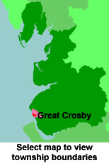
View a map of the boundaries of this town/parish.
You can see maps centred on OS grid reference SJ312995 (Lat/Lon: 53.487756, -3.038557), Great Crosby which are provided by:
- OpenStreetMap
- Google Maps
- StreetMap (Current Ordnance Survey maps)
- Bing (was Multimap)
- Old Maps Online
- National Library of Scotland (Old Ordnance Survey maps)
- Vision of Britain (Click "Historical units & statistics" for administrative areas.)
- English Jurisdictions in 1851 (Unfortunately the LDS have removed the facility to enable us to specify a starting location, you will need to search yourself on their map.)
- Magic (Geographic information) (Click + on map if it doesn't show)
- GeoHack (Links to on-line maps and location specific services.)
- All places within the same township/parish shown on an Openstreetmap map.
- Nearby townships/parishes shown on an Openstreetmap map.
- Nearby places shown on an Openstreetmap map.
For probate purposes prior to 1858, Great Crosby was in the Archdeaconry of Chester, in the Diocese of Chester. The original Lancashire wills for the Archdeaconry of Chester are held at the Lancashire Record Office.
You can also see Family History Societies covering the nearby area, plotted on a map. This facility is being developed, and is awaiting societies to enter information about the places they cover.