
Hide
Great Marsden
hide
Hide
Great Marsden is now called Nelson.
Hide
hide
Hide
hide
Hide
Hide
MARSDEN, a township and two chapelries in Whalley parish, Lancashire. The township consists of the two chapelries, called Little M. and Great M.; lies on the Leeds and Liverpool canal, and on the Lancashire and Yorkshire railway, 2½ and 4 miles NE of Burnley; has two stations on the railway, at Brierfield for Little M., and at Nelson for Great M.; and has a post office, of the name of Nelson-in-Marsden, under Burnley. Acres, of Little M., 1,470; of Great M., 2,890. Real property of the whole, £27,821; of which £1,304 are in quarries, and £11,068 in mines. Pop. of Little M., in 1851, 3,997; in 1861, 5,162. Houses, 1,005. Pop. of Great M., in 1851, 2,071; in 1861, 2,180. Houses, 422. The increase of pop. was caused by the erection of cotton-mills. The property both of Little M. and of Great M. is much subdivided. Marsden Hall is the seat of W. Pinder, Esq.; Southfield, of N. England, Esq.; and Spring House, of T. Mason, Esq. Nelson, in Little M., is lighted with gas, and publishes a weekly newspaper. The cotton manufacture is carried on, and coal and stone abound. Little M. is a p. curacy, Great M. a vicarage, in the dio. of Manchester. Value of Little M., £180;* of Great M., £300.* Patrons of the former, Hulme's Trustees; of the latter, alt. the Crown and the Bishop. The church of Little M. is a plain stone building; and that of Great M. was erected in 1848, at a cost of £2,050, and is in the pointed style. There are chapels for Independents and Quakers, three for Wesleyans, and two for Primitive Methodists, three national schools, and a mechanics' institution.
John Marius Wilson, Imperial Gazetteer of England and Wales (1870-72)
Hide
Nelson Library,
Market Square,
Nelson
BB9 7PU
Details about the census records, and indexes for Great & Little Marsden.
The Register Office covering the Great Marsden area is Burnley and Pendle.
Local information about Nelson provided by Pendle.Net.
The National Gazetteer of Great Britain and Ireland - 1868
"GREAT AND LITTLE MARSDEN, a township in the parish of Whalley, higher division of the hundred of Blackburn, county Lancaster, 3 miles N.E. of Burnley. Whalley is its post town. It has a station on the East Lancashire line of railway, and there is also one at Nelson. Little Marsden is the most populous township, and is situated on the turnpike road leading from Burnley to Colne, and near the river Calder. The township of Great Marsden was formed into a district parish under Sir Robert Peel's Act. A large trade is done in cotton spinning and manufacturing. There are extensive collieries and stone quarries. The soil is of various quality, resting on a subsoil of carboniferous limestone and slate. The land is almost wholly in pasture. The living is a perpetual curacy in the diocese of Manchester, value £150, in the patronage of the crown and bishop alternately. The church, dedicated to St. John, is a neat stone structure erected in 1848 at an expense of £2,050, the greater part of the sum being defrayed by Mrs. Walton and Mrs. Moore. An endowed school for both sexes was founded by the above-named ladies. The living of Little Marsden is a perpetual curacy, value £150, in the patronage of Hulme's trustees. The church is a neat stone structure. There are two National schools, and places of worship for the Wesleyans, Independents, Baptists, and Society of Friends. In the vicinity is Castor Cliff camp, surrounded by a double ditch.
- Ask for a calculation of the distance from Great Marsden to another place.
In 1835 Great and Little Marsden was a township in the parish of Whalley.
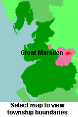
View a map of the boundaries of this town/parish.
You can see maps centred on OS grid reference SD877372 (Lat/Lon: 53.830927, -2.188087), Great Marsden which are provided by:
- OpenStreetMap
- Google Maps
- StreetMap (Current Ordnance Survey maps)
- Bing (was Multimap)
- Old Maps Online
- National Library of Scotland (Old Ordnance Survey maps)
- Vision of Britain (Click "Historical units & statistics" for administrative areas.)
- English Jurisdictions in 1851 (Unfortunately the LDS have removed the facility to enable us to specify a starting location, you will need to search yourself on their map.)
- Magic (Geographic information) (Click + on map if it doesn't show)
- GeoHack (Links to on-line maps and location specific services.)
- All places within the same township/parish shown on an Openstreetmap map.
- Nearby townships/parishes shown on an Openstreetmap map.
- Nearby places shown on an Openstreetmap map.
For probate purposes prior to 1858, Great Marsden was in the Archdeaconry of Chester, in the Diocese of Chester. The original Lancashire wills for the Archdeaconry of Chester are held at the Lancashire Record Office.
You can also see Family History Societies covering the nearby area, plotted on a map. This facility is being developed, and is awaiting societies to enter information about the places they cover.