
Hide
Hoole
hide
Hide
hide
Hide
hide
Hide
Hide
HOOLE, a village, two townships, and a parish in Preston district, Lancashire. The village is Much Hoole; stands near the river Douglas, 2¾ miles NW of Croston r. station, and 7 SW of Preston; and has a post office under Preston. The townships are Much Hoole and Little Hoole; the latter N of the former, and on the estuary of the Ribble. Acres of Much Hoole, 1,701. Real property, £3,511. Pop., 708. Houses, 136. The chief landowners are Lord Lilford and the Marquis de Rothwell. Acres of Little Hoole, 1,222; of which 70 are water. Real property, £2,533. Pop., 424. Houses, 72. A large cotton factory is here. The parish consists of the two townships. The living is a rectory in the diocese of Manchester. Value, £280. Patron, T. B. Addison, Esq. The church was originally a chapel of ease to Croston; is a plain edifice, with a low tower; and was enlarged in 1864. There are chapels for Wesleyans and Primitive Methodists, a national school, and some small charities.
John Marius Wilson, Imperial Gazetteer of England and Wales (1870-72)
Hide
Local studies information is held at Leyland library.
| St Michael Church of England, Hoole |
Details about the census records, and indexes for Hoole.
| St Michael Church of England, Hoole |
The Register Office covering the Hoole area is Preston and South Ribble
The National Gazetteer of Great Britain and Ireland - 1868
"HOOLE, a parish in the hundred of Leyland, county Lancaster, 8 miles S.W. of Preston, its post town, 11 N.E. of Ormskirk, and 2 from the Cockerbar railway station on the East Lancashire line. It is situated on the river Douglas or Astland, and on the old turnpike road between Preston and Liverpool. This parish was separated in 1642 from that of Croston, and contains the townships of Much and Little Hoole. The inhabitants are chiefly engaged in agriculture. The soil is partly a marly loam, alternated with peat-moss and marsh. The tithes have been commuted for a rent-charge of £280. The living is a rectory in the diocese of Manchester, value £280. The church, dedicated to St. Michael, was formerly a chapel-of-ease to Croston. It is a small edifice with a low tower containing one bell. The interior of late has undergone thorough repair. There is an endowed National school for both sexes. A commodious brick building has recently been erected as a schoolhouse, in which a Sunday-school is held. The parochial charities produce about £29 per annum. George Anthony Leigh Keck, Esq., Rev. Richard Renshaw Rothwell, and R. R. Rothwell, Esq., are lords the manor and chief landowners."
- Ask for a calculation of the distance from Hoole to another place.
In 1835 the parish of Hoole contained the townships of Much Hoole and Little Hoole. Information about boundaries and administrative areas is available from A Vision of Britain through time.
View maps of Hoole and places within its boundaries.
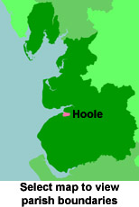
View a map of the boundaries of this town/parish.
You can see maps centred on OS grid reference SD478232 (Lat/Lon: 53.702715, -2.792828), Hoole which are provided by:
- OpenStreetMap
- Google Maps
- StreetMap (Current Ordnance Survey maps)
- Bing (was Multimap)
- Old Maps Online
- National Library of Scotland (Old Ordnance Survey maps)
- Vision of Britain (Click "Historical units & statistics" for administrative areas.)
- English Jurisdictions in 1851 (Unfortunately the LDS have removed the facility to enable us to specify a starting location, you will need to search yourself on their map.)
- Magic (Geographic information) (Click + on map if it doesn't show)
- GeoHack (Links to on-line maps and location specific services.)
- All places within the same township/parish shown on an Openstreetmap map.
- Nearby townships/parishes shown on an Openstreetmap map.
- Nearby places shown on an Openstreetmap map.
For probate purposes prior to 1858, Hoole was in the Archdeaconry of Chester, in the Diocese of Chester. The original Lancashire wills for the Archdeaconry of Chester are held at the Lancashire Record Office.
You can also see Family History Societies covering the nearby area, plotted on a map. This facility is being developed, and is awaiting societies to enter information about the places they cover.