
Hide
Huncoat
hide
Hide
hide
Hide
hide
Hide
Hide
HUNCOAT, a village and a township in Whalley parish, Lancashire. The village stands on a risingground, adjacent to the East Lancashire railway, 1½ mile NE by E of Accrington; and has a station on the railway, and chapels for Baptists and Wesleyans. The township comprises 960 acres. Real property, £2,336; of which £50 are in quarries. Pop. in 1851, 598; in 1861, 839. Houses, 154. The increase of pop. arose from the extension of cotton spinning. The Accrington cemetery and the reservoir of the Accrington waterworks are on the border.
John Marius Wilson, Imperial Gazetteer of England and Wales (1870-72)
Hide
Local studies information is held at Accrington library.
| Burnley Road Cemetery, Huncoat |
Details about the census records, and indexes for Huncoat.
| Higer Gate Rd, Huncoat, Baptist |
| Burnley Road Cemetery, Huncoat |
| Station Road Wesleyan Methodist, Huncoat |
| Our Lady, Huncoat, Roman Catholic |
The Register Office covering the Huncoat area is Hyndburn and Rossendale.
The National Gazetteer of Great Britain and Ireland - 1868
"HUNCOAT, a township in the parish of Whalley, Higher division of the hundred of Blackburn, county Lancaster, 4 miles S.W. of Burnley, 1½ mile from Accrington, and 7 miles from Blackburn. It is astation on the East Lancashire railway. The village is situated on gently rising ground, on the Leeds and Liverpool canal, and consists of a few scattered farmhouses and cottages. The Accrington reservoir is situated on the borders of this township. The Wesleyans and Independents have each a chapel."
- Ask for a calculation of the distance from Huncoat to another place.
In 1835 Huncoat was a township in the parish of Whalley.
Information about boundaries and administrative areas is available from A Vision of Britain through time.
View maps of Huncoat and places within its boundaries.
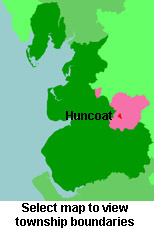
View a map of the boundaries of this town/parish.
You can see maps centred on OS grid reference SD779301 (Lat/Lon: 53.767131, -2.336944), Huncoat which are provided by:
- OpenStreetMap
- Google Maps
- StreetMap (Current Ordnance Survey maps)
- Bing (was Multimap)
- Old Maps Online
- National Library of Scotland (Old Ordnance Survey maps)
- Vision of Britain (Click "Historical units & statistics" for administrative areas.)
- English Jurisdictions in 1851 (Unfortunately the LDS have removed the facility to enable us to specify a starting location, you will need to search yourself on their map.)
- Magic (Geographic information) (Click + on map if it doesn't show)
- GeoHack (Links to on-line maps and location specific services.)
- All places within the same township/parish shown on an Openstreetmap map.
- Nearby townships/parishes shown on an Openstreetmap map.
- Nearby places shown on an Openstreetmap map.
For probate purposes prior to 1858, Huncoat was in the Archdeaconry of Chester, in the Diocese of Chester. The original Lancashire wills for the Archdeaconry of Chester are held at the Lancashire Record Office.
You can also see Family History Societies covering the nearby area, plotted on a map. This facility is being developed, and is awaiting societies to enter information about the places they cover.