
Hide
Ince Blundell
hide
Hide
hide
Hide
hide
Hide
Hide
INCE-BLUNDELL, a village and a township in Sefton parish, Lancashire. The village stands near the river Alt and the Liverpool and Southport railway, 9 miles NNW of Liverpool; and has a very ancient cross, and a Roman Catholic chapel. The township comprises 2,258 acres. Real property, £5,022. Pop., 572. Houses, 91. Most of the land belongs to Thomas W. Blundell, Esq., and part to the Earl of Sefton. InceBlundell Hall, the seat of Mr. Blundell, is a splendid mansion, in a beautiful park; and has attached to it a building modelled exactly after the Pantheon at Rome, but one-third less in size, and containing a rich collection of statuary, paintings, sarcophagi, vases, bronzes, and other objects of interest.
John Marius Wilson, Imperial Gazetteer of England and Wales (1870-72)
Hide
Details about the census records, and indexes for Ince Blundell.
| Holy Family, Ince Blundell, Roman Catholic |
The Register Office covering the Ince Blundell area is Sephton South.
The National Gazetteer of Great Britain and Ireland - 1868
"INCE-BLUNDELL, a township in the parish of Sefton, hundred of West Derby, county Lancaster, 9 miles N. of Liverpool, and 7 S.W. of Ormskirk. It is situated on the river Alt, near the coast. It has been the seat of the Blundells from the reign of Henry IIL, from which it takes its suffix. The land is divided between arable, meadow, and woodland. In the village is a stone cross of a very ancient date. There is a Roman Catholic chapel and day schools. Ince-Blundell Hall, the seat of the Blundell family, is situated in the midst of a wooded park. Close to it is the Pantheon, two-thirds the size of that of Rome, and containing upwards of 500 pieces of sculpture and 200 paintings, some of them by the most celebrated masters, including Raphael's "Fall of Man" and Canova's "Psyche.""
- Ask for a calculation of the distance from Ince Blundell to another place.
In 1835 Ince Blundell was a township in the parish of Sefton.
Information about boundaries and administrative areas is available from A Vision of Britain through time.
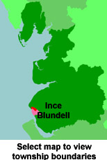
View maps of Ince Blundell and places within its boundaries.
View a map of the boundaries of this town/parish.
You can see maps centred on OS grid reference SD318038 (Lat/Lon: 53.526827, -3.030795), Ince Blundell which are provided by:
- OpenStreetMap
- Google Maps
- StreetMap (Current Ordnance Survey maps)
- Bing (was Multimap)
- Old Maps Online
- National Library of Scotland (Old Ordnance Survey maps)
- Vision of Britain (Click "Historical units & statistics" for administrative areas.)
- English Jurisdictions in 1851 (Unfortunately the LDS have removed the facility to enable us to specify a starting location, you will need to search yourself on their map.)
- Magic (Geographic information) (Click + on map if it doesn't show)
- GeoHack (Links to on-line maps and location specific services.)
- All places within the same township/parish shown on an Openstreetmap map.
- Nearby townships/parishes shown on an Openstreetmap map.
- Nearby places shown on an Openstreetmap map.
For probate purposes prior to 1858, Ince Blundell was in the Archdeaconry of Chester, in the Diocese of Chester. The original Lancashire wills for the Archdeaconry of Chester are held at the Lancashire Record Office.
You can also see Family History Societies covering the nearby area, plotted on a map. This facility is being developed, and is awaiting societies to enter information about the places they cover.